Commons:Featured picture candidates/Image:Primera traza de Córdoba.jpg
Jump to navigation
Jump to search
Image:Primera traza de Córdoba.jpg, not featured
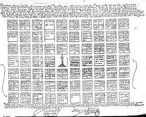
[edit] Info Created by Lorenzo Suárez de Figueroa, 1577. - uploaded by Alakasam - nominated by Alakasam -- Alakasam (talk) 14:07, 7 September 2008 (UTC)
 Support Alakasam (talk) 14:07, 7 September 2008 (UTC)
 Comment The first map of the city of Cordoba (Argentina), was made in 1577, by Lieutenant Governor Don Lorenzo Suarez de Figueroa. The document gives an account of a city with 10 blocks long and 7 wide (70 blocks). The image shows that the lands were divided into 4. It governed for the neighbors, as the land of religious orders were not divided. Alakasam (talk) 14:16, 7 September 2008 (UTC)
 Oppose Interesting document, but very poor quality photocopy not FP-worthy. Lycaon (talk) 14:26, 7 September 2008 (UTC)
 Oppose Interesting, but the scanner has been set to scan as black & white rather than as greyscale. That produces a rather poor copy. --MichaelMaggs (talk) 14:36, 7 September 2008 (UTC)
 Oppose not pic --SuperJew (talk) 11:50, 8 September 2008 (UTC)
result: 1 support, 3 opposes, 0 neutral => not featured (rule of the 5th day). Benh (talk) 13:22, 14 September 2008 (UTC)
