File:Военный конфликт на востоке Украины.svg
Jump to navigation
Jump to search

Size of this PNG preview of this SVG file: 454 × 599 pixels. Other resolutions: 182 × 240 pixels | 364 × 480 pixels | 582 × 768 pixels | 776 × 1,024 pixels | 1,553 × 2,048 pixels | 2,048 × 2,701 pixels.
Original file (SVG file, nominally 2,048 × 2,701 pixels, file size: 1.97 MB)
Captions
Captions
Add a one-line explanation of what this file represents
Summary
[edit]| Description |
Deutsch: 2015 : Eine Karte des Ostens der Ukraine, in dem eine bewaffnete Rebellion im Donbass gegen die ukrainische Zentralregierung im Gange ist. Sie zeigt die unmittelbaren Einflussgebiete beider Seiten.
Aktuell umkämpfte Siedlungen.
Von Rebellen gehaltene Gebiete der Oblast Luhansk.
Von Rebellen gehaltene Gebiete der Oblast Donezk.
Ehemalige Rebellengebiete, von ukrainischen Truppen zurückerobert. English: 2015 : A map of Eastern Ukraine where an ongoing armed conflict between the Ukrainian government and Donbass insurgents takes place. It shows the areas under immediate control of both sides.
Settlements with current fights.
Current Luhansk oblast territory held by insurgents.
Current Donetsk oblast territory held by insurgents.
Territory previously controlled by insurgents but retaken by Ukrainian government forces. Español: 2015 : Mapa de las zonas en Ucrania en las cuales el conflicto armado ha tenido lugar como parte de la insurgencia en la región del Donbass, desde abril de 2014. Este mapa debe ser actualizado regularmente para reflejar la situación actual.
Asentamientos, para los que hay lucha activa ahora.
Territorio controlado por "República Popular de Lugansk".
Territorio controlado por "República Popular de Donetsk".
Territorios anteriormente controlados por los insurgentes, actualmente bajo control del Gobierno de Ucrania. Esperanto: 2015 : Teritorio en kiu okazas armita konflikto en la oriento de Ukrainio. La limoj de la teritorio povas ŝanĝiĝi laŭ la progreso de la armeaj faroj. La mapo regule refreŝiĝados kaj prezentados aktualan situacion.
Enloĝataj lokoj, en kiuj nun okazas militagoj.
Teritorio kontrolata de Luhanska Popola Respubliko.
Teritorio kontrolata de Donecka Popola Respubliko.
Teritorio liberigita far la ukraina armeo de la influo de DPR kaj LPR. Français : 2015 : Carte du conflit armé dans l'est de l'Ukraine. Les limites du territoire peuvent être modifiés pendant les hostilités (certaines localités changent de mains 2-3 fois par jour). Cette carte doit être régulièrement mis à jour pour refléter la situation actuelle.
Zone de combats actuels
Territoire sous le contrôle de la République populaire de Lugansk et de la République populaire de Donetsk
Villes sous le contrôle de la République populaire de Lugansk et de la République populaire de Donetsk
Espace au mains de l'armée ukrainienne Nederlands: 2015 : Een kaart van Oost-Oekraïne waar een gewapend conflict gaande is tussen de Oekraïnse overheid en rebellen uit de Donbass. Het toont de gebieden onder directe controle van beide partijen.
Plaatsen met momentele gevechten.
Momenteel door rebellen gecontroleerd gebied in de Luhansk Oblast.
Momenteel door rebellen gecontroleerd gebied in de Donetsk Oblast.
Gebied voormalig in handen van de Donbass rebellen maar nu in handen van de Oekraïnse overheid. Беларуская (тарашкевіца): Тэрыторыя, на якой адбываецца ўзброены канфлікт на ўсходзе Ўкраіны. Межы тэрыторыі могуць зьмяняцца падчас ваенных дзеяньняў. Гэтая мапа рэгулярна абнаўляецца і адлюстроўвае існую сытуацыю.
Населеныя пункты, за якія ў гэты час ідуць актыўныя баі.
Тэрыторыя пад кантролем «Луганская Народная Рэспубліка».
Тэрыторыя пад кантролем «Данецкая Народная Рэспубліка».
Тэрыторыя, якая вызвалена ўкраінскім войскам.
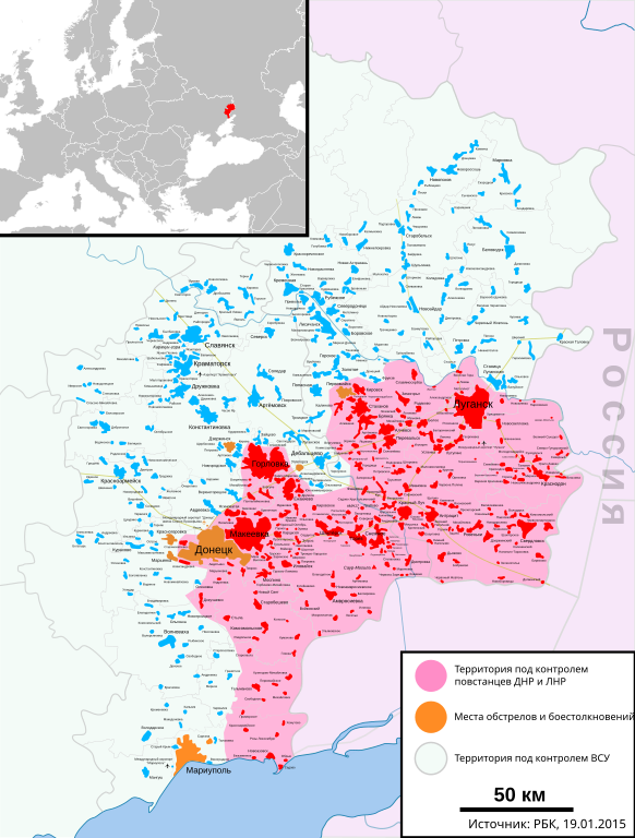
P.S. Ідуць актыўныя баявыя дзеяньні, інфармацыя пра кантроль тэрыторыяў зьмяняецца кожную гадзіну, некаторыя населеныя пункты па 2-3 разы ў дзень пераходзяць з рук у рукі, таму за ўсімі зьменамі проста немагчыма ўсачыць. Калі вы выявілі на карце недакладнасьць, і ў вас ёсьць пацьверджаныя АК, тады сьмела выпраўляйце.Русский: 2015 : Территория, на которой происходит вооружённый конфликт на востоке Украины. Границы территории могут меняться в ходе военных действий. Эта карта должна регулярно обновляется и отражать текущую ситуацию.
Населенные пункты, за которые в настоящее время идут активные бои.
Территория под контролем Луганской Народной Республики.
Территория под контролем Донецкой Народной Республики.
Территория, отвоёванная украинской армией у ДНР и ЛНР.
P.S. Идут активные боевые действия, информация о контроле территорий меняется каждый час, некоторые населенные пункты по 2-3 раза в день из рук в руки переходят, поэтому за всеми изменениями просто невозможно уследить. Если вы обнаружили на карте неточность, и у вас есть подтверждающий АИ, то смело ее исправляйте.Українська: 2015 : Територія, на якій відбувається збройний конфлікт на сході України. Межі території можуть змінюватися в ході військових дій. Ця карта має регулярно оновлюватися та відображати поточну ситуацію. Територія під контролем Донецької Народної Республіки.
Населені пункти, за які на цей момент ідуть активні бої.
Територія під контролем Луганської Народної Республіки.
Територія, відвойована українською армією у ДНР і ЛНР. |
| Date | |
| Source | Own work |
| Author | TarasovOleg http://cdn.thinglink.me/api/image/561604036957044737/1024/10/scaletowidth |
| Other versions |
[]
|


.png)


Licensing
[edit]
I, the copyright holder of this work, hereby publish it under the following license:
This file is licensed under the Creative Commons Attribution-Share Alike 4.0 International license.
- You are free:
- to share – to copy, distribute and transmit the work
- to remix – to adapt the work
- Under the following conditions:
- attribution – You must give appropriate credit, provide a link to the license, and indicate if changes were made. You may do so in any reasonable manner, but not in any way that suggests the licensor endorses you or your use.
- share alike – If you remix, transform, or build upon the material, you must distribute your contributions under the same or compatible license as the original.
File history
Click on a date/time to view the file as it appeared at that time.
| Date/Time | Thumbnail | Dimensions | User | Comment | |
|---|---|---|---|---|---|
| current | 22:17, 29 January 2015 | | 2,048 × 2,701 (1.97 MB) | Gajmar (talk | contribs) | Поправка карты-врезки |
| 22:06, 29 January 2015 |  | 2,048 × 2,701 (1.98 MB) | Gajmar (talk | contribs) | http://top.rbc.ru/politics/19/01/2015/54bd03d09a79474035cf22ae | |
| 21:03, 10 December 2014 |  | 2,048 × 2,701 (1.98 MB) | Artemis Dread (talk | contribs) | Возвращен адекватная версия | |
| 17:20, 9 December 2014 |  | 2,048 × 2,701 (1.88 MB) | Andrej500 (talk | contribs) | Обновлены данные | |
| 12:42, 14 September 2014 |  | 2,048 × 2,701 (1.98 MB) | Цезарь Валентиниан (talk | contribs) | Reverted to version as of 11:07, 5 September 2014 | |
| 16:53, 13 September 2014 |  | 2,048 × 2,701 (1.98 MB) | AshFox (talk | contribs) | Убрал фантазии. | |
| 11:07, 5 September 2014 |  | 2,048 × 2,701 (1.98 MB) | TarasovOleg (talk | contribs) | http://top.rbc.ru/politics/05/09/2014/947309.shtml | |
| 11:05, 2 September 2014 |  | 2,048 × 2,701 (1.98 MB) | TarasovOleg (talk | contribs) | http://top.rbc.ru/politics/01/09/2014/946309.shtml | |
| 06:48, 30 August 2014 |  | 2,048 × 2,701 (1.98 MB) | TarasovOleg (talk | contribs) | User created page with UploadWizard |
You cannot overwrite this file.
File usage on Commons
The following page uses this file:
- File:Военный конфликт в Новороссии.svg (file redirect)
File usage on other wikis
The following other wikis use this file:
- Usage on ru.wikipedia.org