File:Карта Японии.svg
From Wikimedia Commons, the free media repository
Jump to navigation
Jump to search

Size of this PNG preview of this SVG file: 455 × 465 pixels. Other resolutions: 235 × 240 pixels | 470 × 480 pixels | 751 × 768 pixels | 1,002 × 1,024 pixels | 2,004 × 2,048 pixels.
Original file (SVG file, nominally 455 × 465 pixels, file size: 1.86 MB)
File information
Structured data
Captions
Captions
Add a one-line explanation of what this file represents
| DescriptionКарта Японии.svg |
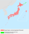
日本語: 日本の位置
Русский: Территория Японии
English: Japan and disputed Kurile islands |
| Date | (UTC) |
| Source | derivative work of Japan location map with side map of the Ryukyu Islands.svg by Maximilian Dörrbecker (Chumwa) |
| Author | see file history |
| This is a retouched picture, which means that it has been digitally altered from its original version. Modifications: added comment. The original can be viewed here: 日本の位置図.svg:
|
I, the copyright holder of this work, hereby publish it under the following license:
| Public domainPublic domainfalsefalse |
| I, the copyright holder of this work, release this work into the public domain. This applies worldwide. In some countries this may not be legally possible; if so: I grant anyone the right to use this work for any purpose, without any conditions, unless such conditions are required by law. |
Original upload log
[edit]This image is a derivative work of the following images:
- File:日本の位置図.svg licensed with PD-self
- 2009-08-08T01:32:28Z Shibo77 466x400 (1961350 Bytes) sxangeto
- 2009-06-14T19:02:06Z Penubag 466x400 (1957328 Bytes) crop
- 2009-06-14T10:44:50Z Hakatanoshio117117 940x477 (2019322 Bytes) {{Information |Description={{ja|1=日本の位置}} |Source=[[:file:LocationMapJapan.png|LocationMapJapan.png]] |Author=[[jp:Hakatanoshio117117|Hakatanoshio117117]] |Date=2009,June.14 |Permission= |other_versions= }} [[Cate
Uploaded with derivativeFX
File history
Click on a date/time to view the file as it appeared at that time.
| Date/Time | Thumbnail | Dimensions | User | Comment | |
|---|---|---|---|---|---|
| current | 22:44, 1 November 2017 |  | 455 × 465 (1.86 MB) | Garam (talk | contribs) | Reverted to version as of 15:02, 17 November 2009 (UTC): diff. version. |
| 20:45, 27 August 2010 |  | 579 × 676 (1.57 MB) | DerFuchs (talk | contribs) | corrections | |
| 15:02, 17 November 2009 |  | 455 × 465 (1.86 MB) | Zero Children (talk | contribs) | correct size of image | |
| 14:24, 17 November 2009 |  | 455 × 455 (1.86 MB) | Zero Children (talk | contribs) | Check size of image | |
| 14:14, 17 November 2009 |  | 461 × 444 (1.86 MB) | Zero Children (talk | contribs) | Correct text | |
| 13:33, 17 November 2009 |  | 461 × 444 (1.86 MB) | Zero Children (talk | contribs) | correct size of image | |
| 13:24, 17 November 2009 |  | 466 × 400 (1.86 MB) | Zero Children (talk | contribs) | {{Information |Description={{ja|1=日本の位置}} {{ru|1=Территория Японии}} |Source=*File:日本の位置図.svg |Date=2009-11-17 12:40 (UTC) |Author=*File:日本の位置図.svg: Hakatanoshio117117 |
You cannot overwrite this file.
File usage on Commons
There are no pages that use this file.
File usage on other wikis
The following other wikis use this file:
- Usage on kk.wikipedia.org
- Usage on ru.wikipedia.org
Metadata
This file contains additional information such as Exif metadata which may have been added by the digital camera, scanner, or software program used to create or digitize it. If the file has been modified from its original state, some details such as the timestamp may not fully reflect those of the original file. The timestamp is only as accurate as the clock in the camera, and it may be completely wrong.
| Width | 455.15085 |
|---|---|
| Height | 465.29999 |