File:1730 Homann Map of the Lower Rhine ( Frankfort, Cologne, Coln, Heidelberg, etc. ) - Geographicus - RhenanusInferior-homann-1730.jpg
Jump to navigation
Jump to search

Size of this preview: 513 × 600 pixels. Other resolutions: 205 × 240 pixels | 410 × 480 pixels | 657 × 768 pixels | 875 × 1,024 pixels | 1,751 × 2,048 pixels | 4,275 × 5,000 pixels.
Original file (4,275 × 5,000 pixels, file size: 9.75 MB, MIME type: image/jpeg)
Captions
Captions
Add a one-line explanation of what this file represents
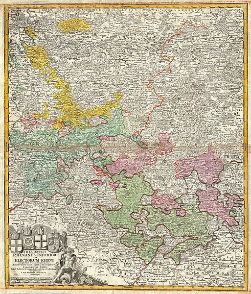
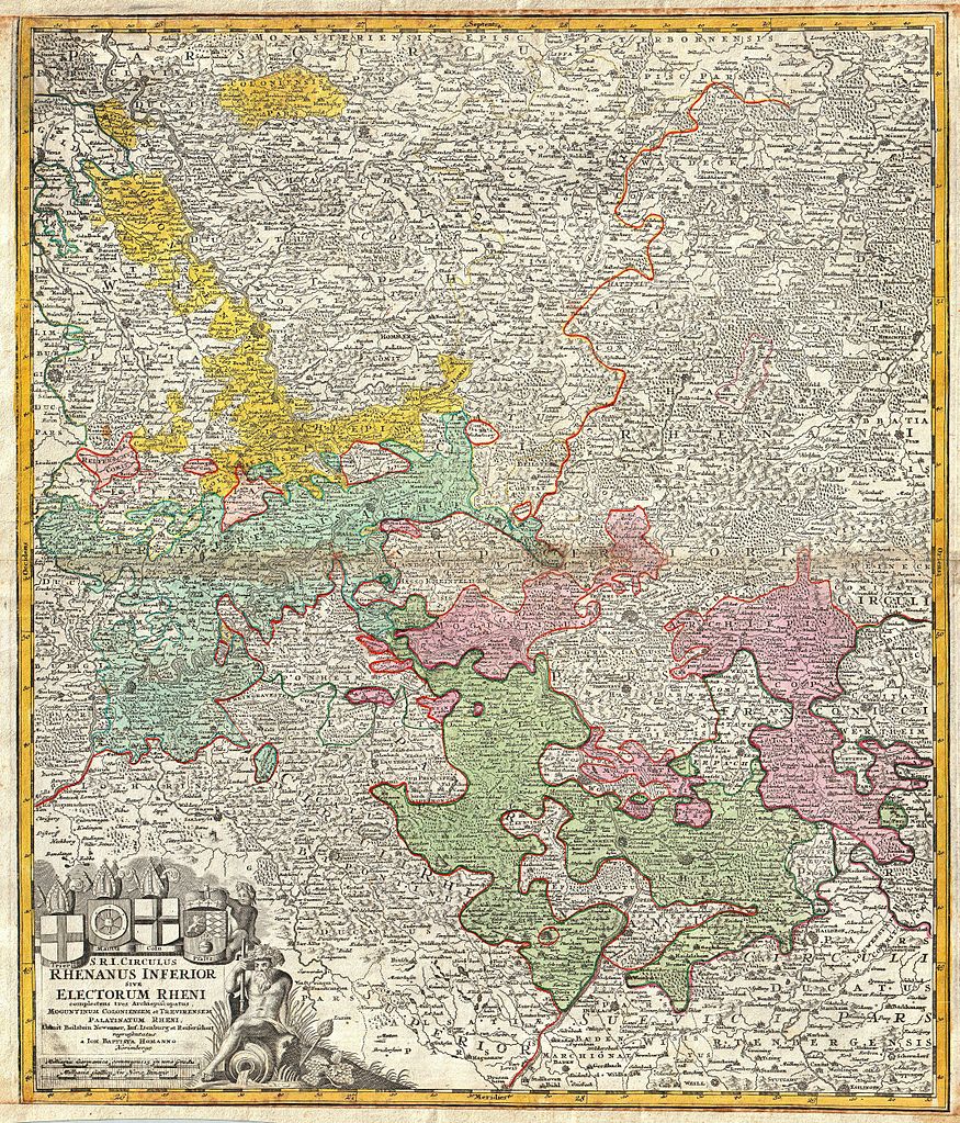
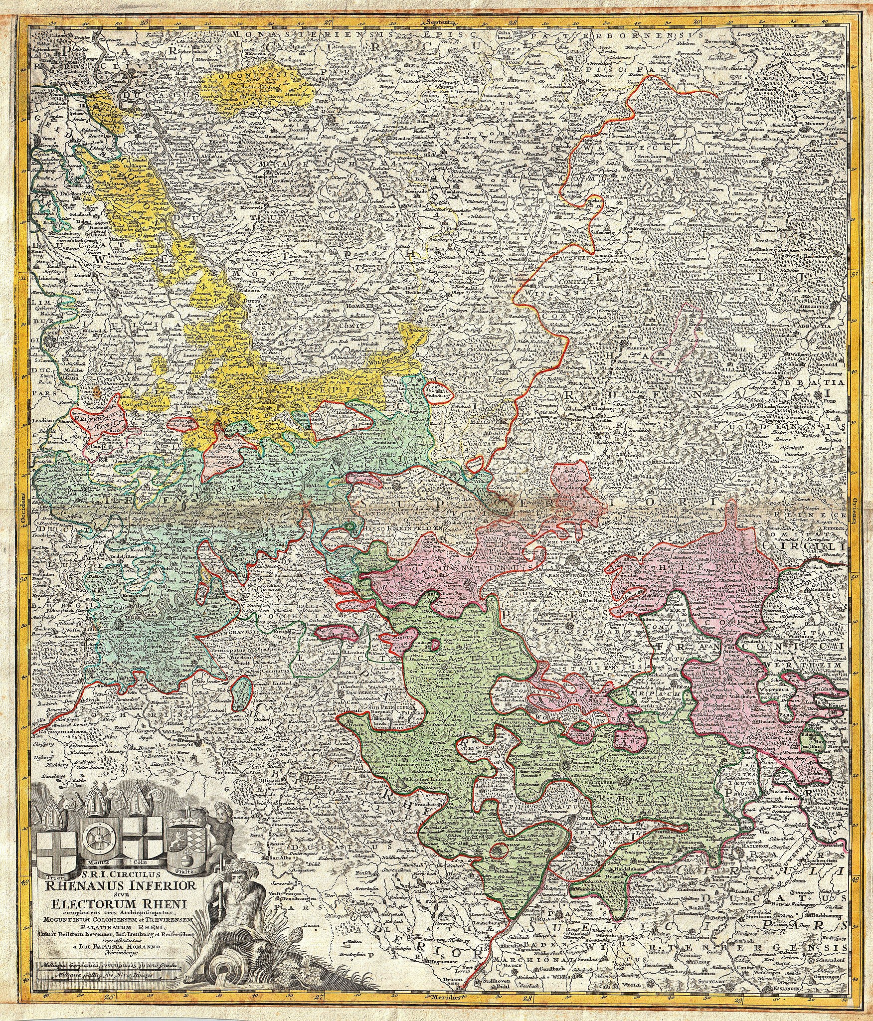
| Johann Homann: S. R. I. Circulus Rhenanus Inferior sive Electorum Rheni Complectens Tres Archiepiscopatus, Moguntinum Coloniensem et Trevirensem, Palatinatum Rheni, Comit. Beilstein Newenaer, Inf. Isenberg et Reiferscheit
( |
||||||||||||||||||||||||
|---|---|---|---|---|---|---|---|---|---|---|---|---|---|---|---|---|---|---|---|---|---|---|---|---|
| Artist |
|
|||||||||||||||||||||||
| Title |
S. R. I. Circulus Rhenanus Inferior sive Electorum Rheni Complectens Tres Archiepiscopatus, Moguntinum Coloniensem et Trevirensem, Palatinatum Rheni, Comit. Beilstein Newenaer, Inf. Isenberg et Reiferscheit |
|||||||||||||||||||||||
| Description |
English: A beautifully detailed c. 1730 Homann Heirs map of Lower Rhine region. Follows the course of the Rhine from Wessel to Seltz. Includes the cities of Frankfurt, Wesel, Mundun, Stuttgart, Heidelberg, Arken, Mulhein, Trier, Maintx, Coln (Cologne) and Pfaltz. The map details fortified cities, villages, roads, bridges, forests, castles and topography. The title cartouche in the upper left quadrant features four heraldic crests, each representing a major city: Trier, Maintz, Coln, Pfaltz. This map was drawn in Nuremberg by J. B. Homann and issued in Homann’s Grosser Atlas as well as in the Homann Heirs’ Maior Atlas Scholasticus ex Triginta Sex Generalibus et Specialibus…. . |
|||||||||||||||||||||||
| Date | circa 1730(undated) | |||||||||||||||||||||||
| Dimensions | height: 23 in (58.4 cm); width: 19.2 in (48.8 cm) | |||||||||||||||||||||||
| Accession number |
Geographicus link: RhenanusInferior-homann-1730 |
|||||||||||||||||||||||
| Source/Photographer |
Major Atlas Scholasticus Ex Triginta sex Generalibus et Specialibus Mappis Homannianis..., c. 1750. / Also issued in Homann's Grosser Atlas
|
|||||||||||||||||||||||
| Permission (Reusing this file) |
|
|||||||||||||||||||||||
.jpg)
File history
Click on a date/time to view the file as it appeared at that time.
| Date/Time | Thumbnail | Dimensions | User | Comment | |
|---|---|---|---|---|---|
| current | 08:00, 17 March 2011 | | 4,275 × 5,000 (9.75 MB) | BotMultichill (talk | contribs) | {{subst:User:Multichill/Geographicus |link=http://www.geographicus.com/P/AntiqueMap/RhenanusInferior-homann-1730 |product_name=1730 Homann Map of the Lower Rhine ( Frankfort, Cologne, Coln, Heidelberg, etc. ) |map_title=S. R. I. Circulus Rhenanus Inferior |
You cannot overwrite this file.
File usage on Commons
The following page uses this file:
_-_Geographicus_-_RhenanusInferior-homann-1730.jpg)
File usage on other wikis
The following other wikis use this file:
- Usage on de.wikipedia.org
_-_Geographicus_-_RhenanusInferior-homann-1730.jpg&oldid=848639200)