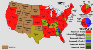
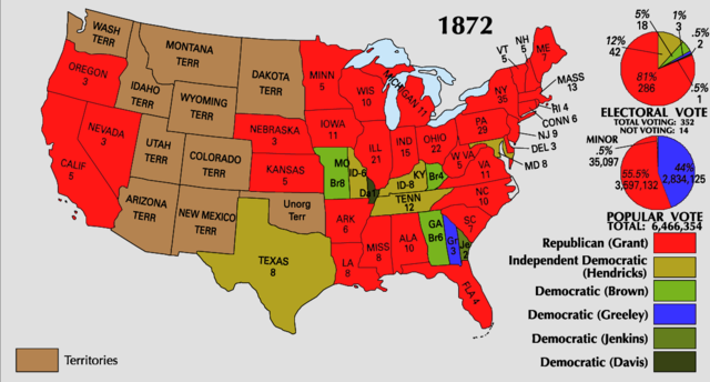
File:1872 Electoral Map.png
Jump to navigation
Jump to search

Size of this preview: 800 × 430 pixels. Other resolutions: 320 × 172 pixels | 640 × 344 pixels | 1,182 × 635 pixels.
Original file (1,182 × 635 pixels, file size: 203 KB, MIME type: image/png)
Captions
Captions
Add a one-line explanation of what this file represents
| U.S. presidential election maps from the National Atlas of the United States |
| See also: SVG maps |
| 1789 · 1792 · 1796 · 1800 · 1804 · 1808 · 1812 · 1816 · 1820 · 1824 · 1828 · 1832 · 1836 · 1840 · 1844 · 1848 · 1852 · 1856 · 1860 · 1864 · 1868 · 1872 · 1876 · 1880 · 1884 · 1888 · 1892 · 1896 · 1900 · 1904 · 1908 · 1912 · 1916 · 1920 · 1924 · 1928 · 1932 · 1936 · 1940 · 1944 · 1948 · 1952 · 1956 · 1960 · 1964 · 1968 · 1972 · 1976 · 1980 · 1984 · 1988 · 1992 · 1996 · 2000 · 2004 · 2008 · 2012 |
.png)
Summary
[edit]
| Description | |
| Source | https://nationalmap.gov/small_scale/printable/elections.html |
| Author | United States Geological Survey |
Licensing
[edit]
This map was obtained from an edition of the National Atlas of the United States. Like almost all works of the U.S. federal government, works from the National Atlas are in the public domain in the United States.
Online access: NationalAtlas.gov | 1970 print edition: Library of Congress, Perry-Castañeda Library
|
File history
Click on a date/time to view the file as it appeared at that time.
| Date/Time | Thumbnail | Dimensions | User | Comment | |
|---|---|---|---|---|---|
| current | 01:23, 8 January 2018 | | 1,182 × 635 (203 KB) | Serafart (talk | contribs) | Reverted to version as of 22:39, 25 June 2008 (UTC) |
| 04:57, 19 February 2011 |  | 1,182 × 635 (156 KB) | Andros 1337 (talk | contribs) | shades of blue for Dems | |
| 22:39, 25 June 2008 |  | 1,182 × 635 (203 KB) | Tallicfan20 (talk | contribs) | better quality | |
| 04:25, 24 June 2008 |  | 1,182 × 635 (191 KB) | Tallicfan20 (talk | contribs) | better quality | |
| 04:17, 25 May 2008 |  | 1,182 × 635 (185 KB) | Tallicfan20 (talk | contribs) | better quality {{PD-USGov-Atlas}} |
You cannot overwrite this file.
File usage on Commons
The following 3 pages use this file:
File usage on other wikis
The following other wikis use this file:
- Usage on en.wikipedia.org
- Usage on it.wikipedia.org
- Usage on no.wikipedia.org
- Usage on sv.wikipedia.org
- Usage on vi.wikipedia.org