File:1903 Alaska boundary dispute.png
From Wikimedia Commons, the free media repository
Jump to navigation
Jump to search
1903_Alaska_boundary_dispute.png (538 × 538 pixels, file size: 16 KB, MIME type: image/png)
File information
Structured data
Captions
Captions
Add a one-line explanation of what this file represents
| Description1903 Alaska boundary dispute.png |
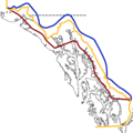
English: Blue is the border as was claimed by the United States, red is the border as was claimed by Canada and the United Kingdom. The Canadian province of British Columbia claimed a greater area, shown in green. Yellow shows the current border, after arbitration in 1903. |
|||
| Date | 26 January 2007 (original upload date) | |||
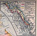
| Source | Partially based on File:1926 Canada-Alaska 1903 boundary-map.jpg | |||
| Author | The original uploader was The shaggy one at English Wikipedia. | |||
| Permission (Reusing this file) |
|
|||
| Other versions |
|

|
This historical map image could be re-created using vector graphics as an SVG file. This has several advantages; see Commons:Media for cleanup for more information. If an SVG form of this image is available, please upload it and afterwards replace this template with
{{vector version available|new image name}}.
It is recommended to name the SVG file “1903 Alaska boundary dispute.svg”—then the template Vector version available (or Vva) does not need the new image name parameter. |
Original upload log
[edit]The original description page was here. All following user names refer to en.wikipedia.
- 2007-01-26 14:45 The shaggy one 538×538×8 (27354 bytes)
- 2007-01-26 14:26 The shaggy one 538×538×8 (25988 bytes)
- 2007-01-26 14:24 The shaggy one 538×538×8 (26024 bytes)
- Map was updated in January 2012 to reflect changes that had been made to the locally-uploaded, identical file on the English Wikipedia in 2008 (see discussion at en:Talk:Alaska boundary dispute), such changes having been made subsequent to the transfer of the file here to the Commons
File history
Click on a date/time to view the file as it appeared at that time.
| Date/Time | Thumbnail | Dimensions | User | Comment | |
|---|---|---|---|---|---|
| current | 15:20, 20 January 2012 |  | 538 × 538 (16 KB) | Skeezix1000 (talk | contribs) | {{Information |Description= |Source= |Date= |Author= |Permission= |other_versions= }} |
| 12:27, 8 December 2007 |  | 538 × 538 (27 KB) | Jonesy22 (talk | contribs) | {{Information |Description=Blue is the border as was claimed by the United States, red is the border as was claimed by Canada and the United Kingdom. Yellow shows the current border, after arbitration in 1903. |Source=The shaggy one |Date= |Author=The sha |
You cannot overwrite this file.
File usage on Commons
There are no pages that use this file.
File usage on other wikis
The following other wikis use this file:
- Usage on ca.wikipedia.org
- Usage on de.wikipedia.org
- Usage on en.wikipedia.org
- Usage on es.wikipedia.org
- Usage on fr.wikipedia.org
- Usage on ja.wikipedia.org
- Usage on pt.wikipedia.org
- Usage on ru.wikipedia.org
- Usage on sk.wikipedia.org
Metadata
This file contains additional information such as Exif metadata which may have been added by the digital camera, scanner, or software program used to create or digitize it. If the file has been modified from its original state, some details such as the timestamp may not fully reflect those of the original file. The timestamp is only as accurate as the clock in the camera, and it may be completely wrong.
| Software used |
|---|
Structured data
Items portrayed in this file
depicts
image/png
8fe1306910ec8ae51f11d413189a7b39fe943d0c
16,647 byte
538 pixel
538 pixel
Categories:
- Maps of the Alexander Archipelago
- Maps of Alaska Panhandle
- Maps of borders of the United States
- Maps of borders of Canada
- Maps of disputed territories in North America
- 1903 in Alaska
- 1903 in British Columbia
- Maps of the history of Alaska
- Maps of the history of Canada
- Maps of British Columbia
- 1903 maps of the United States
- 1903 maps of Canada
- Alaska-Canada border

