File:2000 United States Senate election in Minnesota results map by county.svg
Jump to navigation
Jump to search

Size of this PNG preview of this SVG file: 600 × 600 pixels. Other resolutions: 240 × 240 pixels | 480 × 480 pixels | 768 × 768 pixels | 1,024 × 1,024 pixels | 2,048 × 2,048 pixels | 810 × 810 pixels.
Original file (SVG file, nominally 810 × 810 pixels, file size: 46 KB)
Captions
Captions
Add a one-line explanation of what this file represents
Summary
[edit]| Description |
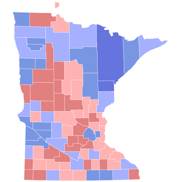
English: Map of 2000 US Senate Election in Minnesota shaded by winning percentage. |
| Date | |
| Source | Own work |
| Author | SpeedMcCool |

Licensing
[edit]
I, the copyright holder of this work, hereby publish it under the following license:
| This file is made available under the Creative Commons CC0 1.0 Universal Public Domain Dedication. | |
| The person who associated a work with this deed has dedicated the work to the public domain by waiving all of their rights to the work worldwide under copyright law, including all related and neighboring rights, to the extent allowed by law. You can copy, modify, distribute and perform the work, even for commercial purposes, all without asking permission.
|
File history
Click on a date/time to view the file as it appeared at that time.
| Date/Time | Thumbnail | Dimensions | User | Comment | |
|---|---|---|---|---|---|
| current | 06:51, 13 February 2024 | | 810 × 810 (46 KB) | Putitonamap98 (talk | contribs) | shapes |
| 00:54, 26 May 2021 |  | 744 × 744 (260 KB) | Petermgrund (talk | contribs) | Reverted to version as of 04:42, 15 May 2021 (UTC) | |
| 02:26, 16 May 2021 |  | 289 × 324 (630 KB) | TylerKutschbach (talk | contribs) | Reverted to version as of 23:47, 14 April 2021 (UTC) stop reverting these maps | |
| 04:42, 15 May 2021 |  | 744 × 744 (260 KB) | Elli (talk | contribs) | not unnecessary, this is for consistency across states and across maps. | |
| 23:47, 14 April 2021 |  | 289 × 324 (630 KB) | TylerKutschbach (talk | contribs) | Reverted to version as of 03:46, 11 April 2021 (UTC) | |
| 05:23, 14 April 2021 |  | 744 × 744 (260 KB) | Elli (talk | contribs) | these shapes work | |
| 03:46, 11 April 2021 |  | 289 × 324 (630 KB) | TylerKutschbach (talk | contribs) | Reverted to version as of 15:43, 27 March 2021 (UTC) unnecessary shapes | |
| 03:14, 10 April 2021 |  | 744 × 744 (319 KB) | Petermgrund (talk | contribs) | Reverted to version as of 04:14, 28 March 2021 (UTC) broken file preview, plus no consensus on new shapes | |
| 05:14, 2 April 2021 |  | 744 × 744 (258 KB) | Awmcphee (talk | contribs) | Version with meaningful text IDs for counties | |
| 04:14, 28 March 2021 |  | 744 × 744 (319 KB) | WikiBunny2K1 (talk | contribs) | Reverted to version as of 17:52, 26 March 2021 (UTC) We are in the process of changing them all. |
You cannot overwrite this file.
File usage on Commons
The following 6 pages use this file:
File usage on other wikis
The following other wikis use this file:
- Usage on en.wikipedia.org