File:2011 Syria protests.svg
Jump to navigation
Jump to search

Size of this PNG preview of this SVG file: 725 × 599 pixels. Other resolutions: 290 × 240 pixels | 581 × 480 pixels | 929 × 768 pixels | 1,239 × 1,024 pixels | 2,478 × 2,048 pixels | 922 × 762 pixels.
Original file (SVG file, nominally 922 × 762 pixels, file size: 287 KB)
Captions
Captions
Add a one-line explanation of what this file represents
W3C-validity not checked.
Summary
[edit]
| Description |
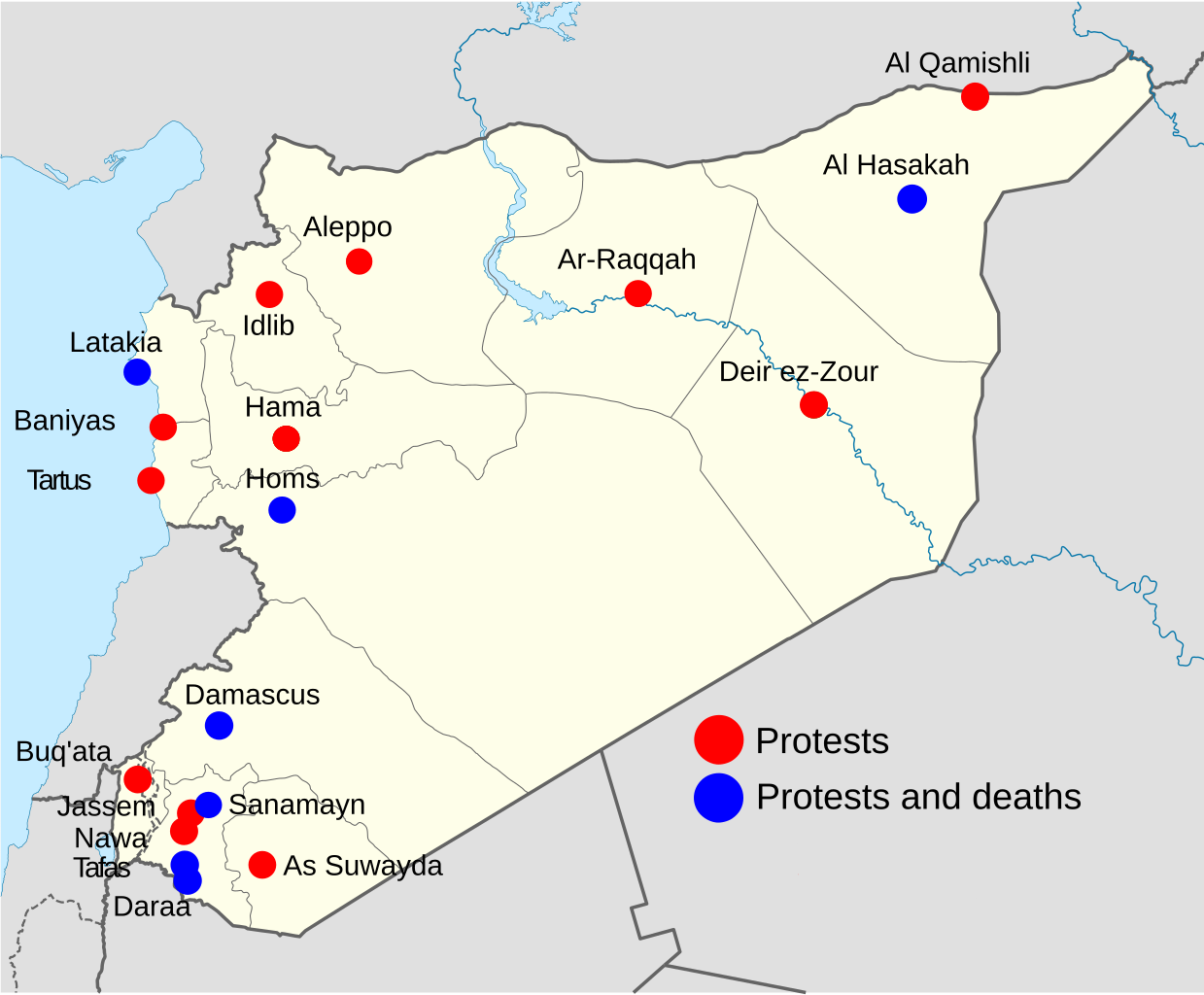
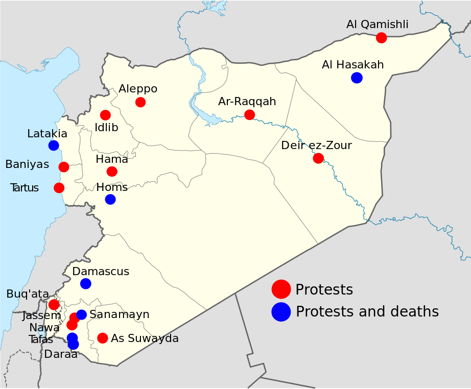
Note: This is an OUTDATED map that stopped being updated since 15 April 2011, protests and deaths has since then occurred in more towns, city's and villages, so this map shouldn't be used at any article. Deutsch: Statuskarte der syrischen Aufstände 2011 English: 2011 Syria protests status map. Français : Carte montrant le status des manifestations en Syrie 2011 Português: Mapa mostrando a situação dos protestos na Síria em 2011 Map is equirectangular projection, N/S stretching 115 %. Geographic limits of the map: * N: 37.6° N * S: 32.0° N * W: 34.9° E * E: 42.7° E |
| Date | (UTC) |
| Source | |
| Author |
|
| Other versions |
Derivative works of this file: |
| This is a retouched picture, which means that it has been digitally altered from its original version. Modifications: Made it into a map for 2011 Syrian protests. The original can be viewed here: Syria location map.svg:
|
I, the copyright holder of this work, hereby publish it under the following licenses:
This file is licensed under the Creative Commons Attribution-Share Alike 3.0 Unported license.
- You are free:
- to share – to copy, distribute and transmit the work
- to remix – to adapt the work
- Under the following conditions:
- attribution – You must give appropriate credit, provide a link to the license, and indicate if changes were made. You may do so in any reasonable manner, but not in any way that suggests the licensor endorses you or your use.
- share alike – If you remix, transform, or build upon the material, you must distribute your contributions under the same or compatible license as the original.

|
Permission is granted to copy, distribute and/or modify this document under the terms of the GNU Free Documentation License, Version 1.2 or any later version published by the Free Software Foundation; with no Invariant Sections, no Front-Cover Texts, and no Back-Cover Texts. A copy of the license is included in the section entitled GNU Free Documentation License. |
You may select the license of your choice.
Original upload log
[edit]
This image is a derivative work of the following images:
- File:Syria_location_map.svg licensed with Cc-by-sa-3.0, GFDL
- 2010-09-30T19:34:14Z NordNordWest 922x762 (250221 Bytes) Reverted to version as of 08:25, 29 September 2010: NO CHANGES WITHOUT DISCUSSION
- 2010-09-30T19:08:16Z Supreme Deliciousness 1000x827 (246114 Bytes) All sources on talkpage show with the same color
- 2010-09-29T08:25:21Z NordNordWest 922x762 (250221 Bytes) Reverted to version as of 18:29, 29 November 2008: no changes without discussion
- 2010-09-29T00:36:20Z Supreme Deliciousness 1000x827 (246114 Bytes) Reverted to version as of 18:38, 22 August 2008
- 2008-11-29T18:29:45Z NordNordWest 922x762 (250221 Bytes) '
- 2008-08-22T18:38:21Z NordNordWest 1000x827 (246114 Bytes) {{Information |Description= {{de|Positionskarte von [[:de:Syrien|Syrien]]}} Quadratische Plattkarte, N-S-Streckung 115 %. Geographische Begrenzung der Karte: * N: 37.6° N * S: 32.0° N * W: 34.9° O * O: 42.7° O {{en|Locati
Uploaded with derivativeFX
File history
Click on a date/time to view the file as it appeared at that time.
| Date/Time | Thumbnail | Dimensions | User | Comment | |
|---|---|---|---|---|---|
| current | 18:55, 12 November 2011 | | 922 × 762 (287 KB) | Fred the Oyster (talk | contribs) | Optimise, change font to the more universal Arial |
| 09:48, 15 April 2011 |  | 922 × 762 (424 KB) | Supreme Deliciousness (talk | contribs) | 14 April + As Suwayda | |
| 10:12, 9 April 2011 |  | 922 × 762 (422 KB) | Supreme Deliciousness (talk | contribs) | April 8, + Tartus, Edlib | |
| 13:19, 2 April 2011 |  | 922 × 762 (420 KB) | Supreme Deliciousness (talk | contribs) | Update April 1-2 Damascus death and Buq'ata. Sorry NikNaks93, cant edit your file, have to use mine. | |
| 11:38, 2 April 2011 |  | 600 × 496 (598 KB) | FunkMonk (talk | contribs) | My mistake. | |
| 10:29, 2 April 2011 |  | 600 × 496 (598 KB) | NikNaks (talk | contribs) | One last try with text as paths | |
| 10:27, 2 April 2011 |  | 600 × 496 (481 KB) | NikNaks (talk | contribs) | Try again. | |
| 10:26, 2 April 2011 |  | 300 × 248 (493 KB) | NikNaks (talk | contribs) | A little cleanup and normalisation to try to fix the text rendering | |
| 18:50, 26 March 2011 |  | 922 × 762 (419 KB) | Supreme Deliciousness (talk | contribs) | Tafas | |
| 00:10, 26 March 2011 |  | 922 × 762 (419 KB) | Supreme Deliciousness (talk | contribs) | Update, 25 March, Sanamayn, Homs, Latakia |
You cannot overwrite this file.
File usage on Commons
The following 5 pages use this file:
File usage on other wikis
The following other wikis use this file:
- Usage on ca.wikinews.org
- Usage on en.wikipedia.org
- Usage on fi.wikipedia.org
- Usage on hu.wikipedia.org
- Usage on it.wikipedia.org
- Usage on sh.wikipedia.org
- Usage on ta.wikipedia.org
- Usage on zh.wikipedia.org