File:2012 Electoral Vote-Cartogram.png
Jump to navigation
Jump to search

Size of this preview: 753 × 600 pixels. Other resolutions: 301 × 240 pixels | 603 × 480 pixels | 964 × 768 pixels | 1,280 × 1,020 pixels | 1,373 × 1,094 pixels.
Original file (1,373 × 1,094 pixels, file size: 63 KB, MIME type: image/png)
Captions
Captions
Add a one-line explanation of what this file represents
Summary
[edit]
| Description |
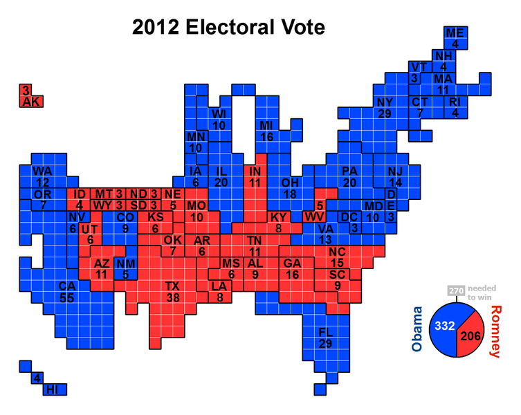
English: Cartogram of the 2012 Electoral Vote for US President, with each square representing one electoral vote. The population density of the 50 states varies by three orders of magnitude (from NJ with nearly 1,200 people per square mile, to AK with roughly 1 1/4 people per sq mi). Because of that huge variation, a regular map of the US that is typically used to present electoral vote results can convey a very skewed impression of the outcome where sparsely populated states appear overrepresented and densely populated states appear underrepresented. The cartogram approach of this image eliminates that problem by presenting the area of each state in an exact one-to-one correspondence with its number of electoral votes. But this is achieved at the cost of introducing distortions to the actual shape of each state and their positioning in relation to each other. |
| Date | |
| Source | Own work |
| Author | ChrisnHouston |

|
File:Cartogram—2012 Electoral Vote.svg is a vector version of this file. It should be used in place of this PNG file when not inferior.
File:2012 Electoral Vote-Cartogram.png → File:Cartogram—2012 Electoral Vote.svg
For more information, see Help:SVG. |
 |
Licensing
[edit]
I, the copyright holder of this work, hereby publish it under the following license:
This file is licensed under the Creative Commons Attribution-Share Alike 3.0 Unported license.
- You are free:
- to share – to copy, distribute and transmit the work
- to remix – to adapt the work
- Under the following conditions:
- attribution – You must give appropriate credit, provide a link to the license, and indicate if changes were made. You may do so in any reasonable manner, but not in any way that suggests the licensor endorses you or your use.
- share alike – If you remix, transform, or build upon the material, you must distribute your contributions under the same or compatible license as the original.
File history
Click on a date/time to view the file as it appeared at that time.
| Date/Time | Thumbnail | Dimensions | User | Comment | |
|---|---|---|---|---|---|
| current | 09:38, 11 November 2012 | | 1,373 × 1,094 (63 KB) | AnonMoos (talk | contribs) | adjust margins, increase PNG compression |
| 19:01, 10 November 2012 |  | 1,500 × 1,200 (126 KB) | Parsecboy (talk | contribs) | CNN now calls Florida for Obama | |
| 00:32, 10 November 2012 |  | 1,500 × 1,200 (128 KB) | Gwickwire (talk | contribs) | Obama has not won Florida yet according to any major news network | |
| 06:23, 9 November 2012 |  | 1,500 × 1,200 (126 KB) | ChrisnHouston (talk | contribs) | Correcting Wisconsin abbreviation, as found by Patteroast. Counting Florida as Obama victory, based on numerous news reports of vote count published by Florida Department of State's official website that Obama has 60,799 more votes ... | |
| 17:43, 7 November 2012 |  | 1,500 × 1,200 (128 KB) | ChrisnHouston (talk | contribs) | Fixing error in Arkansas abbreviation, as noted by Patteroast. --~~~~ | |
| 11:51, 7 November 2012 |  | 1,500 × 1,200 (128 KB) | ChrisnHouston (talk | contribs) | New Mexico was not labeled. Fixed. | |
| 11:25, 7 November 2012 |  | 1,500 × 1,200 (127 KB) | ChrisnHouston (talk | contribs) | User created page with UploadWizard |
You cannot overwrite this file.
File usage on Commons
The following page uses this file:
File usage on other wikis
The following other wikis use this file:
- Usage on fa.wikipedia.org
- Usage on hu.wikipedia.org
- Usage on ro.wikipedia.org
- Usage on sr.wikipedia.org