File:2016 Presidential Election by County.svg
Jump to navigation
Jump to search

Size of this PNG preview of this SVG file: 800 × 507 pixels. Other resolutions: 320 × 203 pixels | 640 × 405 pixels | 1,024 × 649 pixels | 1,280 × 811 pixels | 2,560 × 1,621 pixels | 990 × 627 pixels.
Original file (SVG file, nominally 990 × 627 pixels, file size: 983 KB)
Captions
Captions
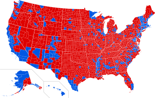
Red Donald Trump Blue Hillary Clinton
Summary
[edit]| Description |
English: 2016 Presidential Election by County |
||||
| Date | |||||
| Source |
This file was derived from: USA Counties.svg |
||||
| Author | Ali Zifan | ||||
| Other versions |
[]
|


.svg)
.svg)


Licensing
[edit]
I, the copyright holder of this work, hereby publish it under the following license:
This file is licensed under the Creative Commons Attribution-Share Alike 4.0 International license.
- You are free:
- to share – to copy, distribute and transmit the work
- to remix – to adapt the work
- Under the following conditions:
- attribution – You must give appropriate credit, provide a link to the license, and indicate if changes were made. You may do so in any reasonable manner, but not in any way that suggests the licensor endorses you or your use.
- share alike – If you remix, transform, or build upon the material, you must distribute your contributions under the same or compatible license as the original.
File history
Click on a date/time to view the file as it appeared at that time.
| Date/Time | Thumbnail | Dimensions | User | Comment | |
|---|---|---|---|---|---|
| current | 04:42, 4 January 2017 | | 990 × 627 (983 KB) | Oganesson007 (talk | contribs) | minor update |
| 04:05, 4 January 2017 |  | 990 × 627 (983 KB) | Oganesson007 (talk | contribs) | Alaska by County + Reduced size + Clean up | |
| 04:06, 26 December 2016 |  | 990 × 627 (1.08 MB) | TL565 (talk | contribs) | Reverted to version as of 21:50, 14 December 2016 (UTC) | |
| 23:55, 25 December 2016 |  | 990 × 627 (1.27 MB) | TL565 (talk | contribs) | Fix Fort Bend county, TX | |
| 00:59, 15 December 2016 |  | 990 × 627 (1.24 MB) | WikiBunny2K1 (talk | contribs) | Correctly colored some counties | |
| 00:02, 15 December 2016 |  | 990 × 627 (1.24 MB) | WikiBunny2K1 (talk | contribs) | Fix to the shape errors | |
| 21:50, 14 December 2016 |  | 990 × 627 (1.08 MB) | WikiBunny2K1 (talk | contribs) | Updated Dutchess County. Can anyone fix the white border near Virginia? It's a bit off from where it's supposed to be. | |
| 01:23, 14 December 2016 |  | 990 × 627 (1.08 MB) | WikiBunny2K1 (talk | contribs) | Fixed Alaska | |
| 11:50, 13 December 2016 |  | 990 × 627 (939 KB) | TL565 (talk | contribs) | Corrections | |
| 22:03, 12 December 2016 |  | 990 × 627 (936 KB) | Tdl1060 (talk | contribs) | Sauk County, Wisconsin voted for Trump https://www.co.sauk.wi.us/sites/default/files/fileattachments/2016november8generalelectionofficialresults.pdf |
You cannot overwrite this file.
File usage on Commons
The following 29 pages use this file:
- User:Magog the Ogre/Political maps/2016 April 1-10
- User:Magog the Ogre/Political maps/2016 December 11-20
- User:Magog the Ogre/Political maps/2016 December 21-31
- User:Magog the Ogre/Political maps/2016 November 1-10
- User:Magog the Ogre/Political maps/2017 January 1-10
- User:Oganesson007/Contributions
- User:OgreBot/Watercraft/2016 December 12
- User:OgreBot/Watercraft/2016 December 15
- User:OgreBot/Watercraft/2016 December 25
- User:OgreBot/Watercraft/2016 December 26
- User:OgreBot/Watercraft/2017 January 4
- File:2016 Presidential Election by County.svg
- File:2016 Presidential Election by County (Percentage of the Vote).svg (file redirect)
- File:2016 Presidential Election by County (Red-Blue-Purple View).png
- File:2016 Presidential Election by County (Red-Blue-Purple View).svg
- File:2016 Presidential Election by County - Clinton.svg
- File:2016 Presidential Election by County - Trump.svg
- File:2016 Presidential Election by State - Clinton.svg
- File:2016 Presidential Election by State - Trump.svg
- File:2016 Presidential Election by Vote Distribution Among States.svg
- File:2016 United States presidential election - Percentage of votes cast for Gary Johnson by county.svg
- File:2016 United States presidential election results map by county.svg
- File:Cartogram—2016 Electoral Vote.svg
- File:ElectoralCollege2016.svg
- File:Results by state, shaded according to winning candidate's percentage of the vote 2016.svg
- File:U.S. 2012 to 2016 presidential election swing.svg
- File:U.S. 2012 to 2016 presidential election swing (relative).svg
- File:United States presidential election, 2016 Cartogram.png
- Template:United States presidential election maps, 2016
.svg&redirect=no)
.png)
.svg)
File usage on other wikis
The following other wikis use this file:
- Usage on bg.wikipedia.org
- Usage on ca.wikipedia.org
- Usage on da.wikipedia.org
- Usage on de.wikipedia.org
- Usage on en.wikipedia.org
- Usage on en.wikiquote.org
- Usage on fa.wikipedia.org
- Usage on fo.wikipedia.org
- Usage on frr.wikipedia.org
- Usage on fr.wikipedia.org
- Usage on hu.wikipedia.org
- Usage on it.wikipedia.org
- Usage on ja.wikipedia.org
- Usage on ko.wikipedia.org
- Usage on mk.wikipedia.org
- Usage on pt.wikipedia.org
- Usage on sk.wikipedia.org
- Usage on sv.wikipedia.org
- Usage on uk.wikipedia.org