File:2016 presidential election, results by congressional district (popular vote margin).svg
Jump to navigation
Jump to search

Size of this PNG preview of this SVG file: 800 × 480 pixels. Other resolutions: 320 × 192 pixels | 1,024 × 615 pixels | 1,280 × 769 pixels | 2,560 × 1,537 pixels | 3,772 × 2,265 pixels.
Original file (SVG file, nominally 3,772 × 2,265 pixels, file size: 2.29 MB)
Captions
Captions
Add a one-line explanation of what this file represents
Summary
[edit].svg&action=edit§ion=1)
| Description |
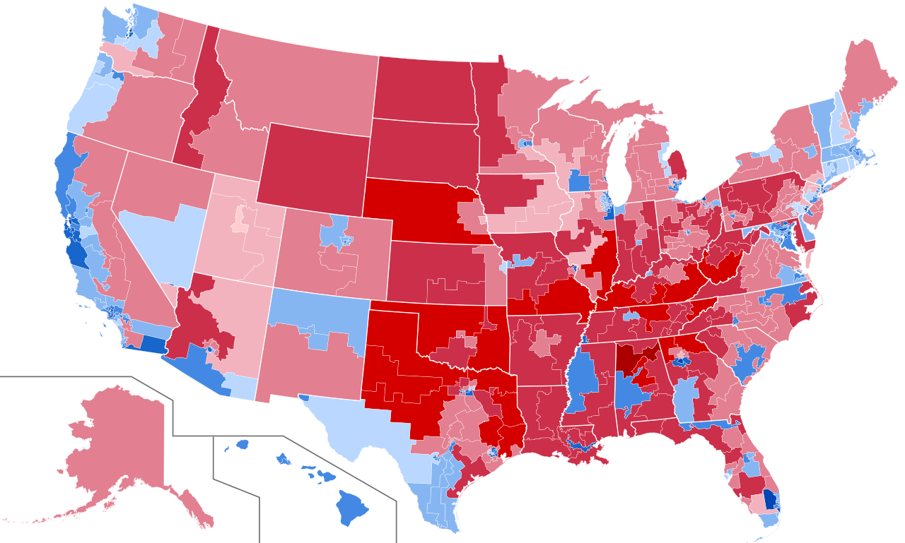
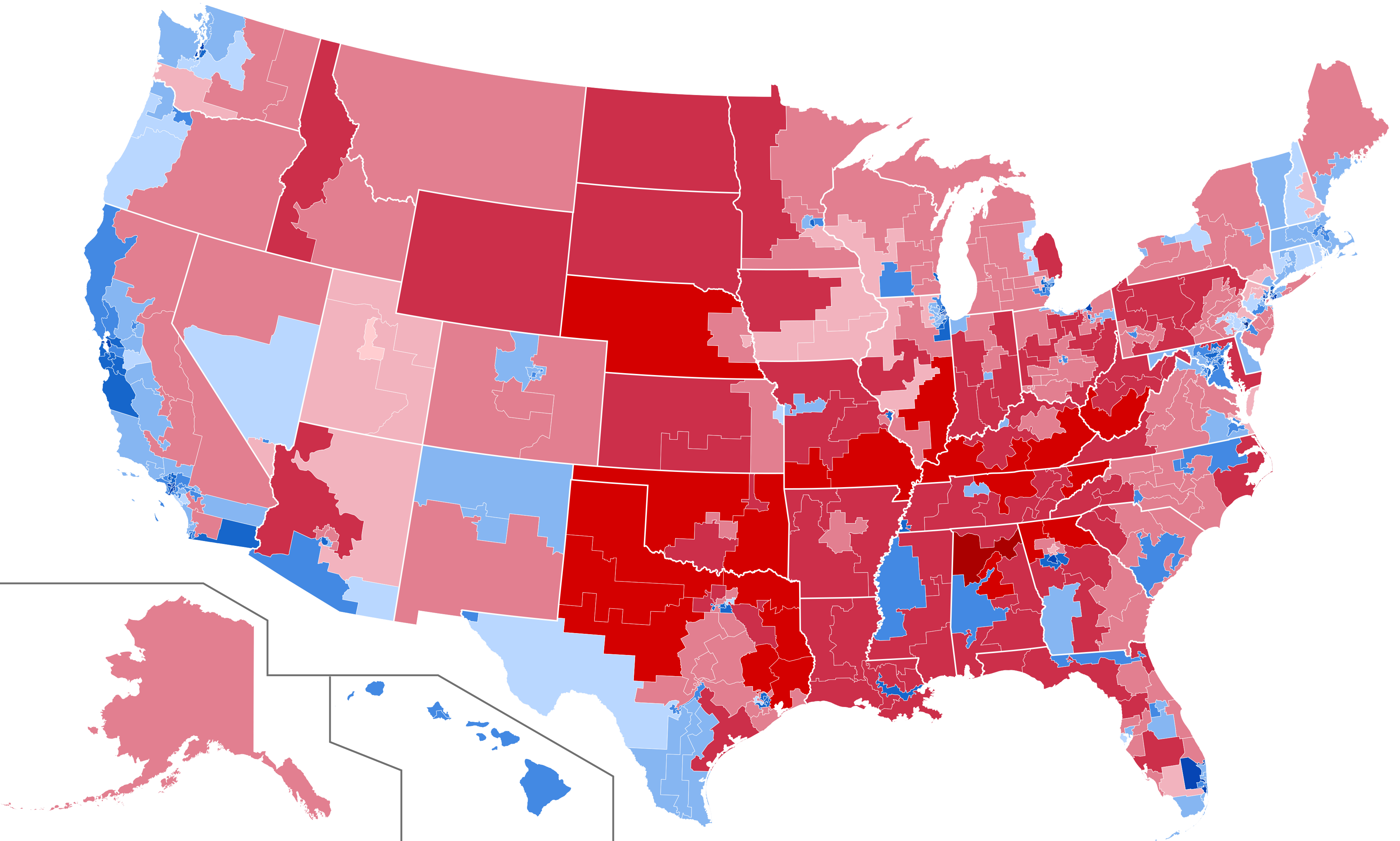
English: Results of 2016 U.S. presidential election by congressional district, shaded by vote margin.
Clinton—>90%
Clinton—80–90%
Clinton—70–80%
Clinton—60–70%
Clinton—50–60%
Clinton—40–50%
Trump—30-40%
Trump—40–50%
Trump—50–60%
Trump—60–70%
Trump—70–80%
Trump—80–90%
` |
| Date | |
| Source | File:US House blank white borders.svg, Data: [1] |
| Author | Mr.Election & Ali Zifan |
| SVG development |
This file is licensed under the Creative Commons Attribution-Share Alike 4.0 International license.
- You are free:
- to share – to copy, distribute and transmit the work
- to remix – to adapt the work
- Under the following conditions:
- attribution – You must give appropriate credit, provide a link to the license, and indicate if changes were made. You may do so in any reasonable manner, but not in any way that suggests the licensor endorses you or your use.
- share alike – If you remix, transform, or build upon the material, you must distribute your contributions under the same or compatible license as the original.
File history
Click on a date/time to view the file as it appeared at that time.
.svg&dir=prev)
.svg&offset=20170124172424)
.svg&offset=&limit=20)
.svg&offset=&limit=50)
.svg&offset=&limit=100)
.svg&offset=&limit=250)
.svg&offset=&limit=500)
| Date/Time | Thumbnail | Dimensions | User | Comment | |
|---|---|---|---|---|---|
| current | 06:00, 1 April 2024 | | 3,772 × 2,265 (2.29 MB) | Gordfather69 (talk | contribs) | Fixed |
| 00:41, 19 March 2018 |  | 3,772 × 2,265 (2.28 MB) | Kingofthedead (talk | contribs) | fix | |
| 22:11, 15 March 2018 |  | 3,772 × 2,265 (2.28 MB) | Kingofthedead (talk | contribs) | fix two TX districts | |
| 18:26, 12 March 2017 |  | 3,772 × 2,265 (2.29 MB) | WikiBunny2K1 (talk | contribs) | Updated | |
| 00:58, 11 March 2017 |  | 3,772 × 2,265 (2.28 MB) | Kingofthedead (talk | contribs) | filled in NC-03 and fixed two districts in Texas | |
| 03:52, 25 February 2017 |  | 3,772 × 2,265 (2.29 MB) | WikiBunny2K1 (talk | contribs) | Added stroke to Hawaii and Alaska | |
| 03:17, 23 February 2017 |  | 3,772 × 2,265 (2.29 MB) | WikiBunny2K1 (talk | contribs) | Finished NY with official data | |
| 04:58, 20 February 2017 |  | 3,772 × 2,265 (2.3 MB) | Oganesson007 (talk | contribs) | fixed some errors + border | |
| 20:58, 29 January 2017 |  | 3,726 × 2,160 (2.1 MB) | WikiBunny2K1 (talk | contribs) | Updated some congressional districts with official data | |
| 17:24, 24 January 2017 |  | 3,726 × 2,160 (2.08 MB) | WikiBunny2K1 (talk | contribs) | Updated NJ-05 |
You cannot overwrite this file.
File usage on Commons
The following 33 pages use this file:
- User:Magog the Ogre/Political maps/2016 December 11-20
- User:Magog the Ogre/Political maps/2016 May 21-31
- User:Magog the Ogre/Political maps/2016 November 1-10
- User:Magog the Ogre/Political maps/2016 November 11-20
- User:Magog the Ogre/Political maps/2016 September 11-20
- User:Magog the Ogre/Political maps/2017 February 19-28
- User:Magog the Ogre/Political maps/2017 January 11-20
- User:Magog the Ogre/Political maps/2017 January 21-31
- User:Magog the Ogre/Political maps/2017 March 11-20
- User:Magog the Ogre/Political maps/2018 March 11-20
- User:Magog the Ogre/Political maps/2024 April 1-10
- User:Oganesson007/Contributions
- User:OgreBot/Watercraft/2016 December 11/Overflow 2
- User:OgreBot/Watercraft/2017 January 14
- User:OgreBot/Watercraft/2017 January 16
- User talk:Kingofthedead/Archive 3
- File:2016 Presidential Election by County.svg
- File:2016 Presidential Election by County (Red-Blue-Purple View).png
- File:2016 Presidential Election by County (Red-Blue-Purple View).svg
- File:2016 Presidential Election by County - Clinton.svg
- File:2016 Presidential Election by County - Trump.svg
- File:2016 Presidential Election by State - Clinton.svg
- File:2016 Presidential Election by State - Trump.svg
- File:2016 Presidential Election by Vote Distribution Among States.svg
- File:2016 United States presidential election - Percentage of votes cast for Gary Johnson by county.svg
- File:2016 United States presidential election results map by county.svg
- File:Cartogram—2016 Electoral Vote.svg
- File:ElectoralCollege2016.svg
- File:Results by state, shaded according to winning candidate's percentage of the vote 2016.svg
- File:U.S. 2012 to 2016 presidential election swing.svg
- File:U.S. 2012 to 2016 presidential election swing (relative).svg
- File:United States presidential election, 2016 Cartogram.png
- Template:United States presidential election maps, 2016
.png)
.svg)
.svg)
File usage on other wikis
The following other wikis use this file:
- Usage on ar.wikipedia.org
- Usage on ca.wikipedia.org
- Usage on cs.wikipedia.org
- Usage on en.wikipedia.org
- Usage on fa.wikipedia.org
- Usage on hu.wikipedia.org
- Usage on it.wikipedia.org
- Usage on ko.wikipedia.org
- Usage on pa.wikipedia.org
- Usage on pnb.wikipedia.org
.svg&oldid=864936320)