File:2018-Migrationstreck-Mexico.jpg
Jump to navigation
Jump to search

Size of this preview: 800 × 523 pixels. Other resolutions: 320 × 209 pixels | 640 × 418 pixels | 1,024 × 669 pixels | 1,280 × 836 pixels | 2,255 × 1,473 pixels.
Original file (2,255 × 1,473 pixels, file size: 2.31 MB, MIME type: image/jpeg)
Captions
Captions
Add a one-line explanation of what this file represents
Summary
[edit]
| Description |
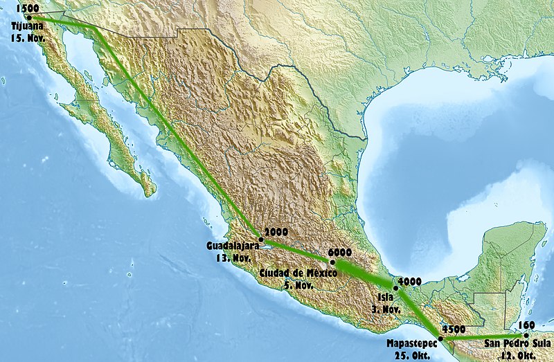
Deutsch: Physische Positionskarte von Mexiko Quadratische Plattkarte, N-S-Streckung 110 %. Geographische Begrenzung der Karte: * N: 33.3° N * S: 14.2° N * W: 118.5° W * O: 86.3° W English: Physical location map of Mexico Equirectangular projection, N/S stretching 110 %. Geographic limits of the map: * N: 33.3° N * S: 14.2° N * W: 118.5° W * E: 86.3° W
Deutsch: Mittelamerikanische Migrantenkaravane Herbst 2018 Der Weg der Karavane wird entsprechend w:en:Central_American_migrant_caravans#Table nachgezeichnet, wobei die Etappen gemäß Tabelle alternierend gefärbt sind. Nederlands: Centraal-Americaanse migrantencaravaan hervst 2018 English: Central American migrant caravan fall 2018 Feel free to improve the map! |
| Date | (UTC) |
| Source | Eigenes Werk, using map data from administrative map by NordNordWest. The relief was created from SRTM-30 relief data |
| Author |
|
| Other versions |
  |
| This is a retouched picture, which means that it has been digitally altered from its original version. Modifications: neue Karte mit Hintergrund der ersten und Daten der zweiten Quelle erstellt. The original can be viewed here: Mexico relief location map.jpg:
|
Licensing
[edit]
This file is licensed under the Creative Commons Attribution 3.0 Unported license.
- You are free:
- to share – to copy, distribute and transmit the work
- to remix – to adapt the work
- Under the following conditions:
- attribution – You must give appropriate credit, provide a link to the license, and indicate if changes were made. You may do so in any reasonable manner, but not in any way that suggests the licensor endorses you or your use.
Original upload log
[edit]
This image is a derivative work of the following images:
Uploaded with derivativeFX
File history
Click on a date/time to view the file as it appeared at that time.
| Date/Time | Thumbnail | Dimensions | User | Comment | |
|---|---|---|---|---|---|
| current | 19:39, 3 December 2018 | | 2,255 × 1,473 (2.31 MB) | Ralf Roletschek (talk | contribs) | == {{int:filedesc}} == {{Information |Description={{de|Physische Positionskarte von {{w|Mexiko|3=de}}}} Quadratische Plattkarte, N-S-Streckung 110 %. Geographische Begrenzung der Karte: * N: 33.3° N * S: 14.2° N * W: 118.5° W * O: 86.3° W {{en|Physical location map of {{w|Mexico}}}} Equirectangular projection, N/S stretching 110 %. Geographic limits of the map: * N: 33.3° N * S: 14.2° N * W: 118.5° W * E: 86.3° W {{de|1=Mittelamerikanische Migrantenkaravane Herbst 2018<br>Der Weg der Karavane... |
You cannot overwrite this file.
File usage on Commons
There are no pages that use this file.
File usage on other wikis
The following other wikis use this file: