File:AMH-2501-NA Map of Table Bay.jpg
Original file (2,400 × 1,720 pixels, file size: 837 KB, MIME type: image/jpeg)
Captions
Captions
Summary
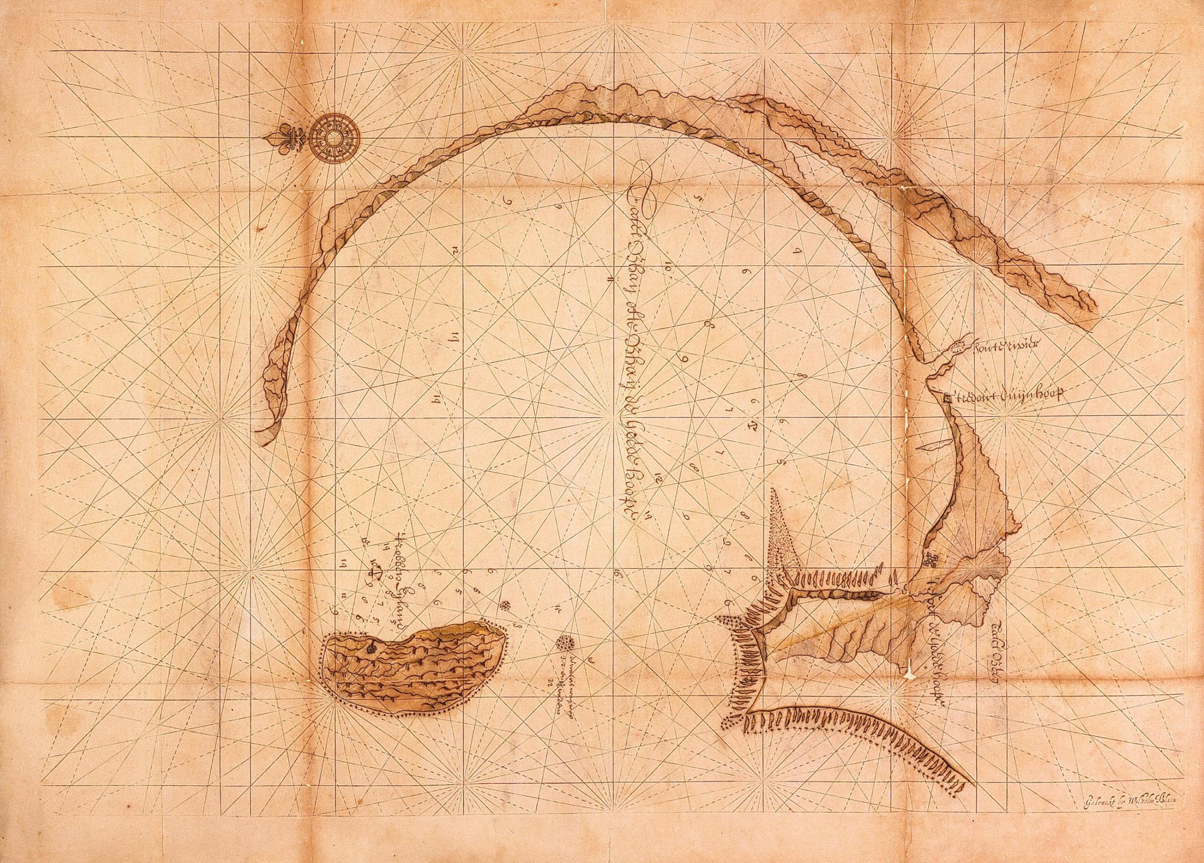
[edit]Nederlands: Kaart van de Tafelbaai
English: Map of Table Bay( |
||||||||||||||||||||||||
|---|---|---|---|---|---|---|---|---|---|---|---|---|---|---|---|---|---|---|---|---|---|---|---|---|
| Author |
Nederlands: Wilhelm (Jansz.) Blaeu (uitgever), Anoniem / Anonymous
English: Wilhelm (Jansz.) Blaeu (publisher), Anoniem / Anonymous |
|||||||||||||||||||||||
| Title |
Nederlands: Kaart van de Tafelbaai
English: Map of Table Bay |
|||||||||||||||||||||||
| Description |
Nederlands: Titel catalogus Leupe (NA): Kaart van de Tafel Bhay ofte Bhay de Goede Hoope.
Kompaslijnen gedrukt bij Willem Blaeu (dit gedrukte papier werd ook na diens sterven in 1638 nog dikwijls gebruikt). Rechts in de baai: t redout Duynhoop.English: Original title according to catalogue Leupe (NA): Kaart van de Tafel Bhay ofte Bhay de Goede Hoope.
Compass lines printed by Willem Blaeu (this printed paper was used often afther his death in 1638). In the bay, it is marked: t redout Duynhoop. |
|||||||||||||||||||||||
| Date | between 1633 and 1685 | |||||||||||||||||||||||
| Medium |
Nederlands: ingekleurde gravure op papier
English: coloured engraving on paper |
|||||||||||||||||||||||
| Dimensions | height: 595 mm (23.42 in); width: 775 mm (30.51 in) | |||||||||||||||||||||||
| Collection |
|
|||||||||||||||||||||||
| Accession number |
NL-HaNA_4.VEL_179 (old number: VEL0179) |
|||||||||||||||||||||||
| Inscriptions |
Tafel Bhaij ofte Bhaij de Goede Hoope
author: Wilhelm Blaeu |
|||||||||||||||||||||||
| Notes |
English: Subjects: chart / map / plan, fortification, compass / dial
Nederlands: Onderwerpen: plattegrond / kaart, vesting, kompas / windroos
English: Post: this image is related to a VOC trading post called Cape Town |
|||||||||||||||||||||||
| Source/Photographer |
|
|||||||||||||||||||||||
| Permission (Reusing this file) |
|
|||||||||||||||||||||||


| Object location | | View this and other nearby images on: OpenStreetMap |
|---|
File history
Click on a date/time to view the file as it appeared at that time.
| Date/Time | Thumbnail | Dimensions | User | Comment | |
|---|---|---|---|---|---|
| current | 15:47, 10 June 2014 | | 2,400 × 1,720 (837 KB) | HuskyBot (talk | contribs) | == {{int:filedesc}} == {{Artwork |title = {{nl|1=Kaart van de Tafelbaai}} {{en|1=Map of Table Bay}} |description = {{nl|1=Titel catalogus Leupe (NA): ''Kaart van de Tafel Bhay ofte Bhay de Goede Hoope''. Kompa... |
You cannot overwrite this file.
File usage on Commons
The following page uses this file: