File:AMH-6097-NA Map of the Cape of Good Hope area.jpg
Original file (2,400 × 978 pixels, file size: 408 KB, MIME type: image/jpeg)
Captions
Captions
Summary
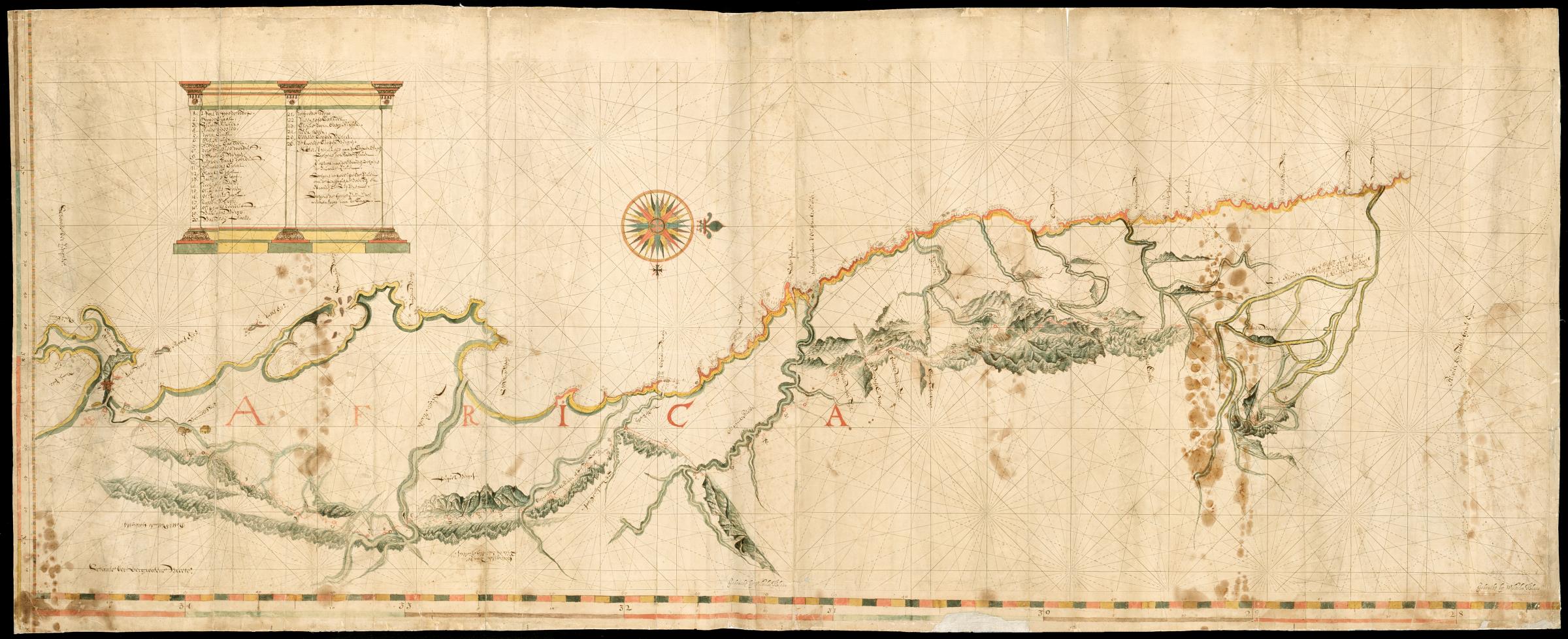
[edit]Nederlands: Kaart van omgeving Kaap de Goede Hoop
English: Map of the Cape of Good Hope area( |
||||||||||||||||||||||||
|---|---|---|---|---|---|---|---|---|---|---|---|---|---|---|---|---|---|---|---|---|---|---|---|---|
| Author |
Nederlands: Wilhelm (Jansz.) Blaeu (drukker)
English: Wilhelm (Jansz.) Blaeu (printer) |
|||||||||||||||||||||||
| Title |
Nederlands: Kaart van omgeving Kaap de Goede Hoop
English: Map of the Cape of Good Hope area |
|||||||||||||||||||||||
| Description |
Nederlands: Titel catalogus Leupe (NA): Kaart van de Landtreys, van de Cabo de Bon Esperance Noordwaerts tot aan de Buffelsrivier.
Kompaslijnen gedrukt bij Willem Blaeu (dit gedrukte papier werd ook na diens sterven in 1638 nog dikwijls gebruikt). De kaart heeft bruine vochtplekken. Notities verso: 498 a [overige notities door restauratie niet meer leesbaar]. Linksboven de legenda, van 1-26. De schaalverdeling is linksonder Schaal der Vergrootende Breedte.English: Title in the Leupe catalogue (NA): Kaart van de Landtreys, van de Cabo de Bon Esperance Noordwaerts tot aan de Buffelsrivier.
Compass lines printed by Willem Blaeu (this printed paper was used often afther his death in 1638). The chart is dotted with brown moisture stains. Notes on reverse: 498 a [other notes are no longer legible as a result of restoration]. Top left the key, from 1-26. The scale is shown bottom left Schaal der Vergrootende Breedte. |
|||||||||||||||||||||||
| Date | between 1675 and 1700 | |||||||||||||||||||||||
| Medium |
Nederlands: ingekleurde tekening op papier
English: coloured drawing on paper |
|||||||||||||||||||||||
| Dimensions | height: 58 cm (22.8 in); width: 144.5 cm (56.8 in) | |||||||||||||||||||||||
| Collection |
|
|||||||||||||||||||||||
| Accession number |
NL-HaNA_4.VEL_851 (old number: VEL0851) |
|||||||||||||||||||||||
| Inscriptions |
Africa
|
|||||||||||||||||||||||
| Notes |
English: Subjects: key, banderole / cartouche / ornamentation, chart / map / plan, flora, compass / dial, fortification
Nederlands: Onderwerpen: legenda, banderol / cartouche / versiering, plattegrond / kaart, flora, kompas / windroos, vesting
English: Post: this image is related to a VOC trading post called Cape Town |
|||||||||||||||||||||||
| Source/Photographer |
|
|||||||||||||||||||||||
| Permission (Reusing this file) |
|
|||||||||||||||||||||||


| Object location | | View this and other nearby images on: OpenStreetMap |
|---|
File history
Click on a date/time to view the file as it appeared at that time.
| Date/Time | Thumbnail | Dimensions | User | Comment | |
|---|---|---|---|---|---|
| current | 08:58, 11 June 2014 | 2,400 × 978 (408 KB) | HuskyBot (talk | contribs) | == {{int:filedesc}} == {{Artwork |title = {{nl|1=Kaart van omgeving Kaap de Goede Hoop}} {{en|1=Map of the Cape of Good Hope area}} |description = {{nl|1=Titel catalogus Leupe (NA): ''Kaart van de Landtreys, va... |
You cannot overwrite this file.
File usage on Commons
The following page uses this file: