File:A Plan of Alexandria now Belhaven.jpg
Jump to navigation
Jump to search
No higher resolution available.
A_Plan_of_Alexandria_now_Belhaven.jpg (640 × 513 pixels, file size: 63 KB, MIME type: image/jpeg)
Captions
Captions
Add a one-line explanation of what this file represents
Summary
[edit]| Description |
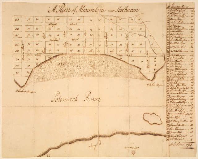
English: "A Plan of Alexandria now Belhaven". George Washington drew this town plan of Alexandria, Va., the first map of the city. The town was formally incorporated on July 13, 1749, and consisted of 84 lots, most of which were 0.5 acres (2,000 m2) in size. The site for this new town focused on a tobacco inspection warehouse and the stores of several Scottish merchants, located on the Potomac River just north of Great Hunting Creek in a small community that was originally known as Belhaven. Washington apparently prepared the map to send to his half-brother Lawrence, who was in England at the time, to show him the two town lots that had been purchased for him. Based on this map, early biographers erroneously concluded that Washington personally designed or was at least heavily involved in the city's formation. While the map is clearly in Washington's hand, there is no documentary evidence to support the claim of Washington's involvement. It is more likely that Washington derived or copied these from originals drawn by someone else,in this case John West Jr., Deputy Surveyor of Fairfax County, whom he assisted in surveying boundaries and lots. Nevertheless, the map stands as a unique example of 18th-century planning and Washington's career as a surveyor and mapmaker. |
|||||||||||||||||||||||
| Date | ||||||||||||||||||||||||
| Source | https://www.loc.gov/item/98687108/ https://www.loc.gov/exhibits/treasures/images/vc004342.jpg | |||||||||||||||||||||||
| Author |
|
|||||||||||||||||||||||
| Other versions |
|
|||||||||||||||||||||||


Licensing
[edit]
|
This work is in the public domain in its country of origin and other countries and areas where the copyright term is the author's life plus 100 years or fewer. This work is in the public domain in the United States because it was published (or registered with the U.S. Copyright Office) before January 1, 1929. | |
| This file has been identified as being free of known restrictions under copyright law, including all related and neighboring rights. | |
File history
Click on a date/time to view the file as it appeared at that time.
| Date/Time | Thumbnail | Dimensions | User | Comment | |
|---|---|---|---|---|---|
| current | 06:57, 26 January 2007 | | 640 × 513 (63 KB) | Doalfe (talk | contribs) | "A Plan of Alexandria now Belhaven". George Washington drew this town plan of Alexandria, Va., the first map of the city. The town was formally incorporated on July 13, 1749, and consisted of 84 lots, most of which were one-half acre in size. The sit |
You cannot overwrite this file.
File usage on Commons
The following 2 pages use this file: