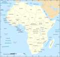
File:Africa map blank.svg

Original file (SVG file, nominally 1,525 × 1,440 pixels, file size: 682 KB)
Captions
Captions
Summary
[edit]| DescriptionAfrica map blank.svg |
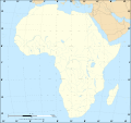
English: Political map of the African continent as in 2011-07.
Français : Carte politique du continent africain tel qu'en 07/2011.
Lambert azimutal equal-area projection, WGS84 datum, standard meridian: 15°E, standard parallel: 0° |
||
| Date | May 2006 (June 2008 for the new version) | ||
| Source |
Own work
|
||
| Author | Eric Gaba (Sting - fr:Sting) | ||
| Permission (Reusing this file) |
|
||
| Other versions |
Derivative works of this file:
[edit]
|
Licensing
[edit]
|
Permission is granted to copy, distribute and/or modify this document under the terms of the GNU Free Documentation License, Version 1.2 or any later version published by the Free Software Foundation; with no Invariant Sections, no Front-Cover Texts, and no Back-Cover Texts. A copy of the license is included in the section entitled GNU Free Documentation License.http://www.gnu.org/copyleft/fdl.htmlGFDLGNU Free Documentation Licensetruetrue |
| This file is licensed under the Creative Commons Attribution-Share Alike 3.0 Unported license. | ||
| ||
| This licensing tag was added to this file as part of the GFDL licensing update.http://creativecommons.org/licenses/by-sa/3.0/CC BY-SA 3.0Creative Commons Attribution-Share Alike 3.0truetrue |
- You are free:
- to share – to copy, distribute and transmit the work
- to remix – to adapt the work
- Under the following conditions:
- attribution – You must give appropriate credit, provide a link to the license, and indicate if changes were made. You may do so in any reasonable manner, but not in any way that suggests the licensor endorses you or your use.
- share alike – If you remix, transform, or build upon the material, you must distribute your contributions under the same or compatible license as the original.
File history
Click on a date/time to view the file as it appeared at that time.
| Date/Time | Thumbnail | Dimensions | User | Comment | |
|---|---|---|---|---|---|
| current | 19:50, 14 July 2011 |  | 1,525 × 1,440 (682 KB) | Sting (talk | contribs) | Sudan/South Sudan 2011-07 border update |
| 20:36, 10 January 2009 |  | 1,525 × 1,440 (693 KB) | Sting (talk | contribs) | Detail correction | |
| 03:34, 27 June 2008 |  | 1,525 × 1,440 (695 KB) | Sting (talk | contribs) | Completely new drawing with known projection | |
| 15:28, 31 May 2006 |  | 1,390 × 1,295 (558 KB) | Sting (talk | contribs) | Enhanced version : African and Asian continents separated | |
| 03:53, 31 May 2006 |  | 1,390 × 1,295 (553 KB) | Sting (talk | contribs) | {{Information |Description=Blank vector graphic map of Africa |Source=Several bitmap-type maps |Date= May 2006 |Author= Eric Gaba (Sting) |Permission=GFDL or CC-BY-SA |other_versions= }} ---- {{fr}} * '''Suj |
You cannot overwrite this file.
File usage on Commons
The following 39 pages use this file:
- User:STyx/Project Mapmaking Wiki Standards
- Commons:Translation possible/En savoir plus
- Commons:Village pump/Archive/2006/07
- File:Aframomum angustifolium distribution.png
- File:Africa map blank.svg
- File:Africa map no countries.svg
- File:Africa map political.svg
- File:African continent-br.svg
- File:African continent-ca.svg
- File:African continent-cs.svg
- File:African continent-da.svg
- File:African continent-de.png
- File:African continent-de.svg
- File:African continent-en.svg
- File:African continent-es.svg
- File:African continent-fr.svg
- File:African continent-it.svg
- File:African continent-ka.svg
- File:African continent-ku.svg
- File:African continent-la.svg
- File:African continent-mk.svg
- File:African continent-nb.svg
- File:African continent-pl.png
- File:African continent-pl.svg
- File:African continent-pt.svg
- File:African continent-ru.svg
- File:African continent-uk.svg
- File:African continent-ur2.svg
- File:African continent-繁體中文.png
- File:African continent-繁體中文.svg
- File:African continent sr.svg
- File:Afrik kárttá smn.svg
- File:Cidades-estado da costa suaíle.png
- File:Cunningham's East African Campaign he.svg
- File:Maravi Kingdom map c. 1650s.svg
- File:Serval range IUCN.svg
- File:The Belgian Campaign in Ethiopia.png
- File:África urbanismos.png
- Template:Other versions/African continent
File usage on other wikis
The following other wikis use this file:
- Usage on el.wikipedia.org
- Usage on en.wikipedia.org
- Usage on es.wikipedia.org
- Usage on fr.wikipedia.org
- Liste des mammifères en république démocratique du Congo
- Liste des mammifères en Algérie
- Liste des mammifères à Sao Tomé-et-Principe
- Liste des mammifères aux Comores
- Liste des mammifères aux îles Éparses de l'océan Indien
- Modèle:Palette Mammifères en Afrique
- Liste des mammifères à La Réunion
- Liste des mammifères à Mayotte
- Liste des mammifères au Maroc
- Modèle:Palette Poissons en Afrique
- Liste des mammifères au Bénin
- Liste des mammifères en Guinée
- Liste des mammifères en Côte d'Ivoire
- Usage on ro.wikipedia.org
- Usage on uk.wikipedia.org
Metadata
This file contains additional information such as Exif metadata which may have been added by the digital camera, scanner, or software program used to create or digitize it. If the file has been modified from its original state, some details such as the timestamp may not fully reflect those of the original file. The timestamp is only as accurate as the clock in the camera, and it may be completely wrong.
| Short title | Blank map of the African continent |
|---|
