File:Antarctic Region.png
Jump to navigation
Jump to search

Size of this preview: 486 × 599 pixels. Other resolutions: 195 × 240 pixels | 389 × 480 pixels | 623 × 768 pixels | 830 × 1,024 pixels | 1,661 × 2,048 pixels | 2,787 × 3,437 pixels.
Original file (2,787 × 3,437 pixels, file size: 1.4 MB, MIME type: image/png)
Captions
Captions
Add a one-line explanation of what this file represents
| Description |
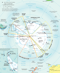
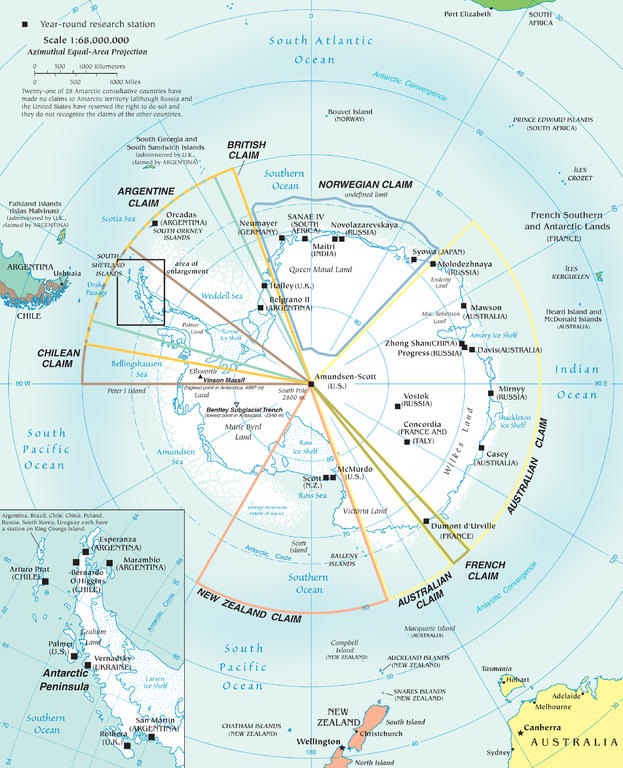
English: Map of the antarctic region
Twenty-one of 28 Antarctic consultative countries have made no claims to Antarctic territory (although Russia and the United States have reserved the right to do so) and they do not recognize the claims of the other countries. Español: Mapa de la Antártida |
| Date | |
| Source | PDF at CIA Factbook |
| Author | The World Factbook |
This image is in the public domain because it contains materials that originally came from the United States Central Intelligence Agency's World Factbook.
|
 |
File history
Click on a date/time to view the file as it appeared at that time.
| Date/Time | Thumbnail | Dimensions | User | Comment | |
|---|---|---|---|---|---|
| current | 18:10, 3 December 2010 | | 2,787 × 3,437 (1.4 MB) | Ras67 (talk | contribs) | better arrangement of Antarctic Peninsula enlargement |
| 20:01, 2 December 2010 |  | 2,787 × 3,437 (1.4 MB) | Ras67 (talk | contribs) | {{Information |Description={{en|1=Map of the antarctic region<br /> Twenty-one of 28 Antarctic consultative countries have made no claims to Antarctic territory (although Russia and the United States have reserved the right to do so) and they do not recog |
You cannot overwrite this file.
File usage on Commons
The following 48 pages use this file:
- Antarctica
- Atlas of Antarctica
- Commons:Copyright rules by territory/Antarctica
- Commons:Copyright rules by territory/Antarctica/ar
- Commons:Copyright rules by territory/Antarctica/de
- Commons:Copyright rules by territory/Antarctica/en
- Commons:Copyright rules by territory/Antarctica/es
- Commons:Copyright rules by territory/Antarctica/fr
- Commons:Copyright rules by territory/Antarctica/gu
- Commons:Copyright rules by territory/Antarctica/it
- Commons:Copyright rules by territory/Antarctica/pl
- Commons:Copyright rules by territory/Antarctica/ru
- Commons:Copyright rules by territory/Antarctica/uk
- Commons:Copyright rules by territory/Antarctica/zh
- File:Adelie Land in Antarctica.svg
- File:Adelie Land in Antarctica (Relief).svg
- File:Antarctica ua.jpg
- File:Antartica (Antartica Chilena Province) in Antarctica (Relief).svg
- File:Argentine Antarctica in Antarctica.svg
- File:Argentine Antarctica in Antarctica (Relief).svg
- File:Auckland Islands in Antarctica (extended).svg
- File:Australian Antarctic Territory in Antarctica.svg
- File:Australian Antarctic Territory in Antarctica (Relief).svg
- File:Bouvet Island in Antarctica (extended).svg
- File:Brazilian Antarctica in Antarctica.svg
- File:British Antarctic Territory in Antarctica.svg
- File:British Antarctic Territory in Antarctica (Relief).svg
- File:British Antarctic Territory in Antarctica (extended).svg
- File:Campbell Island in Antarctica (extended).svg
- File:Chilean Antarctica in Antarctica.svg
- File:Falkland Islands in Antarctica (extended).svg
- File:French Southern Territories in Antarctica (extended).svg
- File:Heard Island and McDonald Islands in Antarctica (extended).svg
- File:Macquarie Island in Antarctica (extended).svg
- File:Marie Byrd Land in Antarctica.svg
- File:Marie Byrd Land in Antarctica (Relief).svg
- File:Peter I Island in Antarctica.svg
- File:Peter I Island in Antarctica (Relief).svg
- File:Prince Edward Islands in Antarctica (extended).svg
- File:Queen Maud Land in Antarctica (Relief).svg
- File:Queen Maud Land in Antarctica (no south borders).svg
- File:Ross Dependency in Antarctica.svg
- File:Ross Dependency in Antarctica (Relief).svg
- File:Ross Dependency in Antarctica (Relief white scheme).svg
- File:South Georgia and the South Sandwich Islands in Antarctica.svg
- File:South Georgia and the South Sandwich Islands in Antarctica (extended).svg
- File:South Georgia and the South Sandwich Islands in Antarctica (special marker).svg
- Category:Marie Byrd Land
.svg)
_in_Antarctica_(Relief).svg)
.svg)
.svg)
.svg)
.svg)
.svg)
.svg)
.svg)
.svg)
.svg)
.svg)
.svg)
.svg)
.svg)
.svg)
.svg)
.svg)
.svg)
.svg)
.svg)
.svg)
File usage on other wikis
The following other wikis use this file:
- Usage on af.wikipedia.org
- Usage on an.wikipedia.org
- Usage on ar.wikipedia.org
- Usage on ast.wikipedia.org
- Usage on az.wikipedia.org
- Usage on be-tarask.wikipedia.org
- Usage on be.wikipedia.org
- Usage on ca.wikipedia.org
- Usage on cs.wikipedia.org
- Usage on de.wikipedia.org
- Usage on de.wikivoyage.org
- Usage on en.wikipedia.org
- Usage on eo.wikipedia.org
- Usage on eu.wikipedia.org
- Usage on fr.wikipedia.org
- Usage on hi.wikipedia.org
- Usage on hu.wikipedia.org
- Usage on hy.wikipedia.org
- Usage on id.wikipedia.org
- Usage on ilo.wikipedia.org
- Usage on ja.wikipedia.org
- Usage on min.wikipedia.org
- Usage on ms.wikipedia.org
- Usage on nl.wikipedia.org
- Usage on nn.wikipedia.org
- Usage on ro.wikipedia.org
- Usage on su.wikipedia.org
- Usage on sv.wikipedia.org
- Usage on uk.wikipedia.org
View more global usage of this file.