File:Arctic Ocean - en.png
From Wikimedia Commons, the free media repository
Jump to navigation
Jump to search
Arctic_Ocean_-_en.png (329 × 330 pixels, file size: 14 KB, MIME type: image/png)
File information
Structured data
Captions
Captions
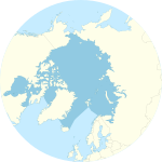
A map of the Arctic Ocean around the north pole, with borders as delineated by the International Hydrographic Organization (IHO), including Hudson Bay (some of which is south of 57°N latitude, off the map)".
বিশ্বের ক্ষুদ্রতম মহাসাগর
Summary
[edit]| This file is an original and may be obsolete for general use, but is kept for historical or archival use. As such, it should not be modified or deleted except to correct upload or technical errors. Any modified versions or replacements of this image should be uploaded with a different file name. Information about this file: 2004 version العربيَّة ∙ čeština ∙ Deutsch ∙ English ∙ español ∙ فارسی ∙ français ∙ magyar ∙ italiano ∙ 日本語 ∙ Lëtzebuergesch ∙ македонски ∙ മലയാളം ∙ Nederlands ∙ português ∙ русский ∙ slovenščina ∙ svenska ∙ 简体中文 ∙ 繁體中文 ∙ 正體中文(臺灣) ∙ +/− |
| DescriptionArctic Ocean - en.png | Arctic Ocean map with English captions showing the North Pole |
| Date | |
| Source | CIA World Factbook (https://www.cia.gov/library/publications/the-world-factbook/geos/xq.html) |
| Author | CIA |
| Other versions | Slovene version: Image:Arctic Ocean-sl.png |
Licensing
[edit]| Public domainPublic domainfalsefalse |
This image is in the public domain because it contains materials that originally came from the United States Central Intelligence Agency's World Factbook.
Bahasa Indonesia ∙ čeština ∙ Deutsch ∙ eesti ∙ English ∙ español ∙ Esperanto ∙ français ∙ galego ∙ hrvatski ∙ italiano ∙ Nederlands ∙ norsk nynorsk ∙ polski ∙ português ∙ sicilianu ∙ slovenščina ∙ suomi ∙ Türkçe ∙ Zazaki ∙ беларуская (тарашкевіца) ∙ македонски ∙ русский ∙ српски / srpski ∙ українська ∙ ქართული ∙ বাংলা ∙ தமிழ் ∙ മലയാളം ∙ 한국어 ∙ 日本語 ∙ 中文 ∙ 中文(简体) ∙ 中文(繁體) ∙ العربية ∙ +/− |
 |

|
File:Arctic Ocean SVG.svg is a vector version of this file. It should be used in place of this PNG file when not inferior.
File:Arctic Ocean - en.png → File:Arctic Ocean SVG.svg
For more information, see Help:SVG.
|
File history
Click on a date/time to view the file as it appeared at that time.
| Date/Time | Thumbnail | Dimensions | User | Comment | |
|---|---|---|---|---|---|
| current | 20:18, 22 August 2009 |  | 329 × 330 (14 KB) | Serg!o (talk | contribs) | == {{int:filedesc}} == {{original||2004 version}} {{Information |Description =Arctic Ocean map with English captions |Source =CIA World Factbook (https://www.cia.gov/library/publications/the-world-factbook/geos/xq.html) |Date =2007-12-13 |Auth |
You cannot overwrite this file.
File usage on Commons
The following 2 pages use this file:
File usage on other wikis
The following other wikis use this file:
- Usage on am.wikipedia.org
- Usage on as.wikipedia.org
- Usage on ban.wikipedia.org
- Usage on blk.wikipedia.org
- Usage on bn.wikipedia.org
- Usage on ckb.wikipedia.org
- Usage on dty.wikipedia.org
- Usage on en.wikipedia.org
- List of islands in the Arctic Ocean
- Convoy PQ 16
- Wikipedia:Society for the Preservation of the Quazer Beast
- Operation Dervish (1941)
- Convoy PQ 1
- Convoy PQ 2
- Farthest North
- Arctic Ocean
- List of Russian explorers
- Convoy PQ 14
- Convoy PQ 11
- Convoy PQ 9/10
- Convoy PQ 8
- Tashi and Nungshi Malik
- Convoy QP 14
- Convoy QP 1
- User:Dronebogus/sandbox
- Portal:Oceans
- Wikipedia:Graphics Lab/Illustration workshop/Archive/Nov 2022
- Usage on en.wikibooks.org
- Usage on en.wikisource.org
- Usage on en.wikiversity.org
- Usage on es.wikipedia.org
- Usage on eu.wikipedia.org
- Usage on fa.wikipedia.org
- Usage on fi.wiktionary.org
- Usage on fr.wikipedia.org
- Usage on gu.wikipedia.org
- Usage on gv.wikipedia.org
- Usage on hr.wiktionary.org
- Usage on ilo.wikipedia.org
View more global usage of this file.

