File:Arizona Republican Presidential Primary Election Results by County, 2016.svg

Original file (SVG file, nominally 810 × 810 pixels, file size: 17 KB)
Captions
Captions
Summary
[edit]| DescriptionArizona Republican Presidential Primary Election Results by County, 2016.svg |
English: Arizona Republican Presidential Primary Election Results by County, 2016
|
||||||
| Date | |||||||
| Source | Own work | ||||||
| Author | Ali Zifan; colored by Supernino | ||||||
| Other versions |
[edit]
|
Licensing
[edit]| This file is made available under the Creative Commons CC0 1.0 Universal Public Domain Dedication. | |
| The person who associated a work with this deed has dedicated the work to the public domain by waiving all of their rights to the work worldwide under copyright law, including all related and neighboring rights, to the extent allowed by law. You can copy, modify, distribute and perform the work, even for commercial purposes, all without asking permission.
http://creativecommons.org/publicdomain/zero/1.0/deed.enCC0Creative Commons Zero, Public Domain Dedicationfalsefalse |
File history
Click on a date/time to view the file as it appeared at that time.
| Date/Time | Thumbnail | Dimensions | User | Comment | |
|---|---|---|---|---|---|
| current | 19:35, 23 May 2023 |  | 810 × 810 (17 KB) | Putitonamap98 (talk | contribs) | shapes |
| 18:13, 26 December 2022 |  | 744 × 744 (152 KB) | Putitonamap98 (talk | contribs) | shapes | |
| 20:42, 20 October 2020 | 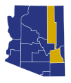 | 277 × 323 (14 KB) | Coffee (talk | contribs) | No, it isn't, please review File:Arizona_Locator_Map.PNG | |
| 03:48, 20 October 2020 |  | 277 × 323 (16 KB) | TylerKutschbach (talk | contribs) | Reverted to version as of 09:03, 25 March 2016 (UTC) we use this for the Arizona maps | |
| 15:56, 19 October 2020 |  | 277 × 323 (14 KB) | Coffee (talk | contribs) | Fixing rotation to actually match the longitudes and latitudes of the state. The prior rotation is a confusion created by looking at a globe from the center of the United States, and is simply inaccurate. | |
| 09:03, 25 March 2016 |  | 277 × 323 (16 KB) | Supernino (talk | contribs) | fix Navajo county (cf. http://apps.azsos.gov/election/2016/PPE/Results/PPE2016Results.htm) | |
| 20:15, 23 March 2016 |  | 277 × 323 (16 KB) | Supernino (talk | contribs) | updated with results | |
| 09:04, 31 January 2016 |  | 277 × 323 (16 KB) | Oganesson007 (talk | contribs) | User created page with UploadWizard |
You cannot overwrite this file.
File usage on Commons
More than 100 pages use this file. The following list shows the first 100 pages that use this file only. A full list is available.
- File:2016 Democrat Primary Dates USA w territories.svg
- File:2K16 GOPrimary.svg
- File:Alabama Democratic Presidential Primary Election Results by County, 2016.svg
- File:Alabama Republican Presidential Primary Election Results by County, 2016.svg
- File:Alaska Democratic Presidential Caucuses Election Results by State House District, 2016.svg
- File:Alaska Republican Presidential Caucuses Election Results by State House District, 2016.svg
- File:Arizona Democratic Presidential Primary Election Results by County, 2016.svg
- File:Arizona Republican Presidential Caucuses Election Results by County, 2016.svg (file redirect)
- File:Arizona Republican Presidential Primary Election Results by County, 2016.svg
- File:Arkansas Democratic Presidential Primary Election Results by County, 2016.svg
- File:Arkansas Republican Presidential Primary Election Results by County, 2016.svg
- File:California Democratic Presidential Primary Election Results by County, 2016.svg
- File:California Republican Presidential Primary Election Results by County, 2016.svg
- File:Colorado Democratic Presidential Caucuses Election Results by County, 2016.svg
- File:Colorado Republican Presidential Caucuses Election Results by County, 2016.svg
- File:Connecticut Democratic Presidential Primary Election Results by County, 2016.svg
- File:Connecticut Republican Presidential Primary Election Results by County, 2016.svg
- File:Delaware Democratic Presidential Primary Election Results by County, 2016.svg
- File:Delaware Republican Presidential Primary Election Results by County, 2016.svg
- File:Democratic Party presidential primaries results, 2016.svg
- File:Democratic Party presidential primaries results by county, 2016.svg
- File:District of Columbia Democratic Presidential Primary Election Results by County, 2016.svg
- File:District of Columbia Republican Presidential Caucuses Election Results by County, 2016.svg
- File:Florida Democratic Presidential Primary Election Results by County, 2016.svg
- File:Florida Republican Presidential Primary Election Results by County, 2016.svg
- File:Georgia Democratic Presidential Primary Election Results by County, 2016.svg
- File:Georgia Republican Presidential Primary Election Results by County, 2016.svg
- File:Hawaii Democratic Presidential Caucuses Election Results by County, 2016.svg
- File:Hawaii Republican Presidential Caucuses Election Results by County, 2016.svg
- File:Idaho Democratic Presidential Caucuses Election Results by County, 2016.svg
- File:Idaho Republican Presidential Primary Election Results by County, 2016.svg
- File:Illinois Democratic Presidential Primary Election Results by County, 2016.svg
- File:Illinois Republican Presidential Primary Election Results by County, 2016.svg
- File:Indiana Democratic Presidential Primary Election Results by County, 2016.svg
- File:Indiana Republican Presidential Primary Election Results by County, 2016.svg
- File:Iowa Democratic Presidential Caucuses Election Results by County, 2016.svg
- File:Iowa Republican Presidential Caucuses Election Results by County, 2016.svg
- File:Kansas Democratic Presidential Caucuses Election Results by Congressional District, 2016.svg
- File:Kansas Republican Presidential Caucuses Election Results by Congressional District, 2016.svg
- File:Kentucky Democratic Presidential Primary Election Results by County, 2016.svg
- File:Kentucky Republican Presidential Caucuses Election Results by County, 2016.svg
- File:Louisiana Democratic Presidential Primary Election Results by County, 2016.svg
- File:Louisiana Republican Presidential Primary Election Results by County, 2016.svg
- File:Maine Democratic Presidential Caucuses Election Results by County, 2016.svg
- File:Maine Republican Presidential Caucuses Election Results by County, 2016.svg
- File:Maryland Democratic Presidential Primary Election Results by County, 2016.svg
- File:Maryland Republican Presidential Primary Election Results by County, 2016.svg
- File:Massachusetts Democratic Presidential Primary Election Results by County, 2016.svg
- File:Massachusetts Republican Presidential Primary Election Results by County, 2016.svg
- File:Michigan Democratic Presidential Primary Election Results by County, 2016.svg
- File:Michigan Republican Presidential Primary Election Results by County, 2016.svg
- File:Minnesota Democratic Presidential Caucuses Election Results by County, 2016.svg
- File:Minnesota Republican Presidential Caucuses Election Results by County, 2016.svg
- File:Mississippi Democratic Presidential Primary Election Results by County, 2016.svg
- File:Mississippi Republican Presidential Primary Election Results by County, 2016.svg
- File:Missouri Democratic Presidential Primary Election Results by County, 2016.svg
- File:Missouri Republican Presidential Primary Election Results by County, 2016.svg
- File:Montana Democratic Presidential Primary Election Results by County, 2016.svg
- File:Montana Republican Presidential Primary Election Results by County, 2016.svg
- File:Nebraska Democratic Presidential Caucuses Election Results by County, 2016.svg
- File:Nebraska Republican Presidential Primary Election Results by County, 2016.svg
- File:Nevada Democratic Presidential Caucuses Election Results by County, 2016.svg
- File:Nevada Republican Presidential Caucuses Election Results by County, 2016.svg
- File:New Hampshire Democratic Presidential Primary Election Results by County, 2016.svg
- File:New Hampshire Republican Presidential Primary Election Results by County, 2016.svg
- File:New Jersey Democratic Presidential Primary Election Results by County, 2016.svg
- File:New Jersey Republican Presidential Primary Election Results by County, 2016.svg
- File:New Mexico Democratic Presidential Primary Election Results by County, 2016.svg
- File:New Mexico Republican Presidential Primary Election Results by County, 2016.svg
- File:New York Democratic Presidential Primary Election Results by County, 2016.svg
- File:New York Republican Presidential Primary Election Results by County, 2016.svg
- File:North Carolina Democratic Presidential Primary Election Results by County, 2016.svg
- File:North Carolina Republican Presidential Primary Election Results by County, 2016.svg
- File:North Dakota Democratic Presidential Caucuses Election Results by County, 2016.svg
- File:North Dakota Republican Presidential Caucuses Election Results by County, 2016.svg
- File:Ohio Democratic Presidential Primary Election Results by County, 2016.svg
- File:Ohio Republican Presidential Primary Election Results by County, 2016.svg
- File:Oklahoma Democratic Presidential Primary Election Results by County, 2016.svg
- File:Oklahoma Republican Presidential Primary Election Results by County, 2016.svg
- File:Oregon Democratic Presidential Primary Election Results by County, 2016.svg
- File:Oregon Republican Presidential Primary Election Results by County, 2016.svg
- File:Pennsylvania Democratic Presidential Primary Election Results by County, 2016.svg
- File:Pennsylvania Republican Presidential Primary Election Results by County, 2016.svg
- File:Polling map for the 2016 Democratic primaries.svg
- File:Republican Party presidential primaries results, 2016.svg
- File:Republican Party presidential primaries results by county, 2016.svg
- File:Rhode Island Democratic Presidential Primary Election Results by County, 2016.svg
- File:Rhode Island Republican Presidential Primary Election Results by County, 2016.svg
- File:South Carolina Democratic Presidential Primary Election Results by County, 2016.svg
- File:South Carolina Republican Presidential Primary Election Results by County, 2016.svg
- File:South Dakota Democratic Presidential Primary Election Results by County, 2016.svg
- File:South Dakota Republican Presidential Primary Election Results by County, 2016.svg
- File:Statewide opinion polling for the Republican Party presidential primaries, 2016.svg
- File:Tennessee Democratic Presidential Primary Election Results by County, 2016.svg
- File:Tennessee Republican Presidential Primary Election Results by County, 2016.svg
- File:Texas Republican Presidential Primary Election Results by County, 2016.svg
- File:Utah Republican Presidential Caucuses Election Results by County, 2016.svg
- File:Vermont Republican Presidential Primary Election Results by County, 2016.svg
- File:Virginia Republican Presidential Primary Election Results by County, 2016.svg
- File:Washington Republican Presidential Primary Election Results by County, 2016.svg
View more links to this file.
File usage on other wikis
The following other wikis use this file:
- Usage on en.wikipedia.org
- Usage on it.wikipedia.org
Metadata
This file contains additional information such as Exif metadata which may have been added by the digital camera, scanner, or software program used to create or digitize it. If the file has been modified from its original state, some details such as the timestamp may not fully reflect those of the original file. The timestamp is only as accurate as the clock in the camera, and it may be completely wrong.
| Width | 810 |
|---|---|
| Height | 810 |


