File:AtlBalk680.jpg
AtlBalk680.jpg (318 × 327 pixels, file size: 155 KB, MIME type: image/jpeg)
Captions
Captions

|
This historical map image could be re-created using vector graphics as an SVG file. This has several advantages; see Commons:Media for cleanup for more information. If an SVG form of this image is available, please upload it and afterwards replace this template with
{{vector version available|new image name}}.
It is recommended to name the SVG file “AtlBalk680.svg”—then the template Vector version available (or Vva) does not need the new image name parameter. |


Summary
[edit]
| Description |
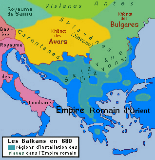
English: Historic map of Balkan peninsula, year 680
Français : Carte des Balkans et l'an 680 |
| Date | |
| Source | Own work |
| Author | Spiridon MANOLIU |
| Other versions |
.jpg) , ,  |
Cette carte, comme les 36 autres de cette série, est une synthèse du "Westermann Grosser Atlas zur Weltgeschichte", 1985, ISBN 3-14-100919-8, du "DTV Atlas zur Weltgeschichte", 1987 traduit chez Perrin, ISBN 2-7242-3596-7, du "Putzger historischer Weltatlas Cornelsen" 1990, ISBN 3-464-00176-8, de l'"Atlas historique Georges Duby" chez Larousse 1987, ISBN 2-03-503009-9, de la série des "Atlas des Peuples" d'André et Jean Sellier à La Découverte : "Europe occidentale" : 1995, ISBN 2-7071-2505-9, "Europe centrale" : 1992, ISBN 2-7071-2032-4, "Orient" : 1993, ISBN 2-7071-2222-X, avec des détails pris dans le Történelmi atlasz de l'Académie hongroise, 1991, ISBN 963-351-422-3 CM et dans l'Atlas istorico-geografic de l'Académie roumaine, 1995, ISBN 973-27-0500-0.
Licensing
[edit]

|
Permission is granted to copy, distribute and/or modify this document under the terms of the GNU Free Documentation License, Version 1.2 or any later version published by the Free Software Foundation; with no Invariant Sections, no Front-Cover Texts, and no Back-Cover Texts. A copy of the license is included in the section entitled GNU Free Documentation License. |
- You are free:
- to share – to copy, distribute and transmit the work
- to remix – to adapt the work
- Under the following conditions:
- attribution – You must give appropriate credit, provide a link to the license, and indicate if changes were made. You may do so in any reasonable manner, but not in any way that suggests the licensor endorses you or your use.
- share alike – If you remix, transform, or build upon the material, you must distribute your contributions under the same or compatible license as the original.
File history
Click on a date/time to view the file as it appeared at that time.
| Date/Time | Thumbnail | Dimensions | User | Comment | |
|---|---|---|---|---|---|
| current | 19:20, 1 March 2010 | | 318 × 327 (155 KB) | Spiridon Ion Cepleanu (talk | contribs) | {{Information |Description={{en|1=Historic map of Balkan peninsula, year 680}} {{fr|1=Carte des Balkans et l'an 680}} |Source={{own}} |Author=Spiridon MANOLIU |Date=March 1, 2010 |Permission= |other_versions= }} Cette carte, comm |
You cannot overwrite this file.
File usage on Commons
The following 2 pages use this file:
File usage on other wikis
The following other wikis use this file:
- Usage on bg.wikipedia.org
- Usage on fr.wikipedia.org
- Histoire de la Roumanie
- Histoire de l'Albanie
- Histoire de la Bulgarie
- Histoire de la Croatie
- Histoire de la Hongrie
- Histoire de la Slovénie
- Histoire de la Serbie
- Histoire de la Macédoine du Nord
- Histoire de la Bosnie-Herzégovine
- Histoire du Monténégro
- Wikipédia:Atelier graphique/Cartes/Archives/février 2019
- Portail:Balkans
- Portail:Balkans/Histoire
- Histoire des Balkans
- Usage on it.wikipedia.org
- Usage on pt.wikipedia.org
- Usage on ru.wikipedia.org
- Usage on sh.wikipedia.org
- Usage on zh.wikipedia.org
Metadata
- Maps of the history of the medieval Balkans
- Maps of the Byzantine empire in the 7th century
- Maps showing the 680s
- Maps of 7th-century Bulgaria
- Maps of the history of Romania in the Middle Ages
- Maps of Eurasian Avars
- Avar Khaganate
- Maps of Samo's realm
- French-language maps of Europe
- Romania in the 7th century
- 680 in Romania
- Derivative maps of Putzgers Historischer Schul-Atlas
- Maps of Sclavinia