File:Autobahnnetz Taiwan.svg
Jump to navigation
Jump to search

Size of this PNG preview of this SVG file: 431 × 599 pixels. Other resolutions: 173 × 240 pixels | 345 × 480 pixels | 553 × 768 pixels | 737 × 1,024 pixels | 1,474 × 2,048 pixels | 770 × 1,070 pixels.
Original file (SVG file, nominally 770 × 1,070 pixels, file size: 427 KB)
Captions
Captions
Add a one-line explanation of what this file represents
Summary
[edit]| Description |
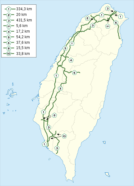
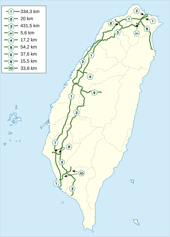
Deutsch: Das Autobahnnetz Taiwans.
English: National Freeway Net of Taiwan.
中文(臺灣):中華民國 (臺灣) 國道高速公路網。
中文(繁體):中華民國 (臺灣) 國道高速公路網。
中文(中国大陆):中华民国 (台湾) 国道高速公路网。
中文(简体):中华民国 (台湾) 国道高速公路网。
日本語: 中華民国(台湾)の国道自動車道ネット。 |
||
| Date | |||
| Source |
This file was derived from: ROC 2016 Presidential Election Township level.svg This vector image includes elements that have been taken or adapted from this file: This vector image includes elements that have been taken or adapted from this file: This vector image includes elements that have been taken or adapted from this file: This vector image includes elements that have been taken or adapted from this file: This vector image includes elements that have been taken or adapted from this file: This vector image includes elements that have been taken or adapted from this file: This vector image includes elements that have been taken or adapted from this file: This vector image includes elements that have been taken or adapted from this file: This vector image includes elements that have been taken or adapted from this file: |
||
| Author | Furfur | ||
| Permission (Reusing this file) |
I, the copyright holder of this work, hereby publish it under the following licenses:
This file is licensed under the Creative Commons Attribution-Share Alike 4.0 International license.
You may select the license of your choice. |
||
| SVG development | This map was created with Adobe Illustrator. |

File history
Click on a date/time to view the file as it appeared at that time.
| Date/Time | Thumbnail | Dimensions | User | Comment | |
|---|---|---|---|---|---|
| current | 16:05, 20 June 2024 | | 770 × 1,070 (427 KB) | SCP-2000 (talk | contribs) | Per request in zhwiki Telegram group https://t.me/wikipedia_zh_ac/132602. Remove the mistake (at the top of the map). |
| 08:55, 13 April 2019 |  | 770 × 1,070 (428 KB) | Furfur (talk | contribs) | elongated NH5 | |
| 17:23, 23 March 2019 |  | 770 × 1,070 (426 KB) | Furfur (talk | contribs) | Detail | |
| 17:14, 23 March 2019 |  | 770 × 1,070 (455 KB) | Furfur (talk | contribs) | Detail | |
| 17:06, 23 March 2019 |  | 770 × 1,070 (455 KB) | Furfur (talk | contribs) | == {{int:filedesc}} == {{Information |Description={{User:Medium69/Traduction}} {{de|1=Das Autobahnnetz Taiwans.}} |Source={{Derived from|ROC 2016 Presidential Election Township level.svg}}{{AttribSVG|1=TWHW1.svg|by={{U|Jimmy3421}}}}{{AttribSVG|1=TWHW2.svg|by={{U|Jimmy3421}}}}{{AttribSVG|1=TWHW3.svg|by={{U|Jimmy3421}}}}{{AttribSVG|1=TWHW3a.svg|by={{U|Jimmy3421}}}}{{AttribSVG|1=TWHW4.svg|by={{U|Jimmy3421}}}}{{AttribSVG|1=TWHW5.svg|by={{U|Jimmy3421}}}}{{AttribSVG|1=TWHW6.svg|by={{U|Jimmy3421}}}}... |
You cannot overwrite this file.
File usage on Commons
The following 9 pages use this file:
- User:Chumwa/OgreBot/Potential transport maps/2019 April 11-20
- User:Chumwa/OgreBot/Potential transport maps/2019 March 21-31
- User:Chumwa/OgreBot/Transport Maps/2019 April 11-20
- User:Chumwa/OgreBot/Transport Maps/2019 March 21-31
- User:Chumwa/OgreBot/Transport Maps/2024 June 11-20
- User:Chumwa/OgreBot/Travel and communication maps/2019 April 11-20
- User:Chumwa/OgreBot/Travel and communication maps/2019 March 21-31
- User:Chumwa/OgreBot/Travel and communication maps/2024 June 11-20
- Commons:Files used on the AARoads Wiki/7
File usage on other wikis
The following other wikis use this file:
- Usage on de.wikipedia.org
- Usage on en.wikipedia.org
- Usage on fr.wikipedia.org
- Usage on ja.wikipedia.org
- Usage on nl.wikipedia.org
- Usage on zh.wikipedia.org