File:Autonome Region Kurdistan (Karte).png
Jump to navigation
Jump to search
Size of this preview: 581 × 599 pixels. Other resolutions: 233 × 240 pixels | 465 × 480 pixels | 1,012 × 1,044 pixels.
Original file (1,012 × 1,044 pixels, file size: 278 KB, MIME type: image/png)
Captions
Captions
Add a one-line explanation of what this file represents
| Description |
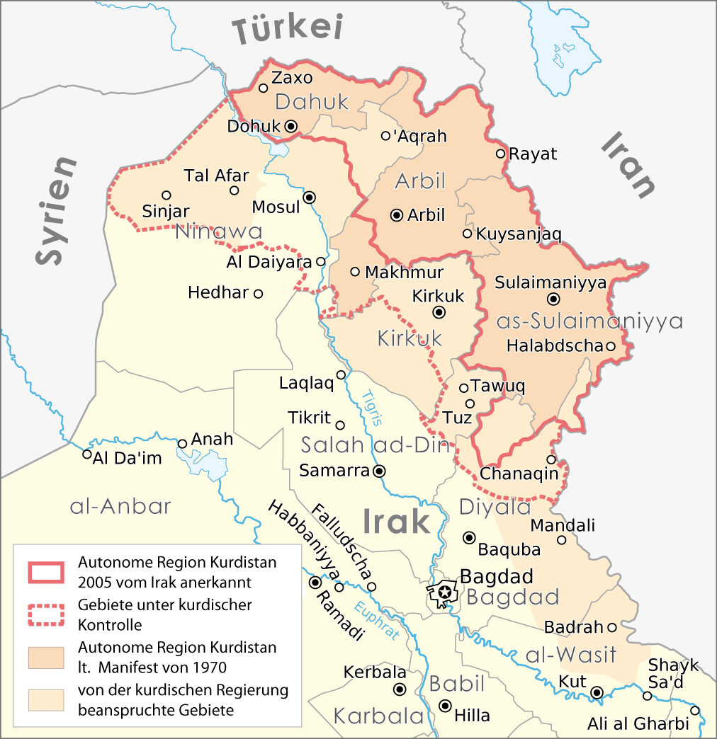
Deutsch: Karte: Autonome Region Kurdistan |
||
| Date | |||
| Source |
Self made, using |
||
| Author |
Maximilian Dörrbecker (Chumwa)
|
||
| Permission (Reusing this file) |
I, the copyright holder of this work, hereby publish it under the following license: This file is licensed under the Creative Commons Attribution-Share Alike 2.5 Generic license.
Sie dürfen das Bild zu den folgenden Bedingungen nutzen:
|
||
| Other versions |
|


| Annotations | This image is annotated: View the annotations at Commons |
.png)
File history
Click on a date/time to view the file as it appeared at that time.
| Date/Time | Thumbnail | Dimensions | User | Comment | |
|---|---|---|---|---|---|
| current | 13:26, 15 August 2016 | | 1,012 × 1,044 (278 KB) | Denniss (talk | contribs) | Reverted to version as of 17:02, 22 September 2008 (UTC) |
| 19:32, 5 August 2016 |  | 1,012 × 1,044 (227 KB) | Beshogur (talk | contribs) | Reverted to version as of 06:40, 21 June 2008 (UTC) Mosul, Tal Afar is not under KRG controll. | |
| 18:55, 16 September 2011 |  | 1,012 × 1,044 (278 KB) | Kathovo (talk | contribs) | Reverted to version as of 21:38, 14 August 2010 | |
| 20:51, 19 August 2010 |  | 1,012 × 1,044 (202 KB) | Saadwand (talk | contribs) | Reverted to version as of 11:32, 14 August 2010 | |
| 21:38, 14 August 2010 |  | 1,012 × 1,044 (278 KB) | 84user (talk | contribs) | Reverted to version as of 17:02, 22 September 2008 reverting apparenty erroneous colour change | |
| 11:32, 14 August 2010 |  | 1,012 × 1,044 (202 KB) | Abuadab (talk | contribs) | minore colour change. | |
| 17:02, 22 September 2008 |  | 1,012 × 1,044 (278 KB) | Chumwa (talk | contribs) | Informationen aus [http://www.washingtonpost.com/wp-dyn/content/graphic/2008/09/13/GR2008091300327.html dieser Karte] integriert. | |
| 06:40, 21 June 2008 |  | 1,012 × 1,044 (227 KB) | Chumwa (talk | contribs) | diverse Anmerkungen eingearbeitet | |
| 05:00, 20 June 2008 |  | 1,012 × 1,044 (284 KB) | Chumwa (talk | contribs) | Komplett neuer Aufbau der Karte | |
| 17:24, 16 June 2008 |  | 831 × 784 (37 KB) | Chumwa (talk | contribs) | {{Information |Description= {{ de }} Karte: Autonome Region Kurdistan |Source=Self made, using * base map #1 * base map #2 |Date=June 2008 |Author=[[:de:User:Chumwa|Maximil |
You cannot overwrite this file.
File usage on Commons
The following 2 pages use this file:
File usage on other wikis
The following other wikis use this file:
- Usage on de.wikipedia.org
- Usage on ku.wikipedia.org
- Usage on tr.wikipedia.org
.png&oldid=808702574)