File:Azerbaijan relief location map.jpg
Jump to navigation
Jump to search

Size of this preview: 783 × 600 pixels. Other resolutions: 314 × 240 pixels | 627 × 480 pixels | 1,003 × 768 pixels | 1,200 × 919 pixels.
Original file (1,200 × 919 pixels, file size: 698 KB, MIME type: image/jpeg)
Captions
Captions
Add a one-line explanation of what this file represents
Summary
[edit]| Description |
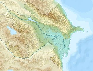
English: Location map of Azerbaijan.
Equirectangular projection. Strechted by 131.0%. Geographic limits of the map: * N: 42.0° N * S: 38.2° N * W: 44.5° E * E: 51.0° EMade with Natural Earth. Free vector and raster map data @ naturalearthdata.com. |
| Date | |
| Source | Own work |
| Author | Uwe Dedering |
| Other versions |
|


Licensing
[edit]
I, the copyright holder of this work, hereby publish it under the following licenses:
This file is licensed under the Creative Commons Attribution-Share Alike 3.0 Unported license.
- You are free:
- to share – to copy, distribute and transmit the work
- to remix – to adapt the work
- Under the following conditions:
- attribution – You must give appropriate credit, provide a link to the license, and indicate if changes were made. You may do so in any reasonable manner, but not in any way that suggests the licensor endorses you or your use.
- share alike – If you remix, transform, or build upon the material, you must distribute your contributions under the same or compatible license as the original.

|
Permission is granted to copy, distribute and/or modify this document under the terms of the GNU Free Documentation License, Version 1.2 or any later version published by the Free Software Foundation; with no Invariant Sections, no Front-Cover Texts, and no Back-Cover Texts. A copy of the license is included in the section entitled GNU Free Documentation License. |
You may select the license of your choice.
File history
Click on a date/time to view the file as it appeared at that time.
| Date/Time | Thumbnail | Dimensions | User | Comment | |
|---|---|---|---|---|---|
| current | 19:12, 9 June 2010 | | 1,200 × 919 (698 KB) | Uwe Dedering (talk | contribs) | one more (ex-?)exklave |
| 18:48, 9 June 2010 |  | 1,200 × 919 (698 KB) | Uwe Dedering (talk | contribs) | {{Information |Description={{en|1=Location map of Azerbaijan. Equirectangular projection. Strechted by 131.0%. Geographic limits of the map: * N: 42.0° N * S: 38.2° N * W: 44.5° E * E: 51.0° E Made with Natural Earth. Free vector and raster map |
You cannot overwrite this file.
File usage on Commons
The following 5 pages use this file:
File usage on other wikis
The following other wikis use this file:
- Usage on ab.wikipedia.org
- Usage on ar.wikipedia.org
- Usage on ast.wikipedia.org
- Usage on av.wikipedia.org
- Usage on azb.wikipedia.org
- Usage on az.wikipedia.org
- Çigil
- Kiçik Zirə
- Daş Zirə
- Zənbil
- Azərbaycan coğrafiyası
- Daşlı ada
- Səngi Muğan
- Gil adası
- Xərə Zirə
- Çilov adası
- Pirallahı adası
- Adsız adası
- Tava adası
- Karvansaray adası
- Qutan adası
- Xanlar adası
- Qu adası
- Kür dili adası
- Qoltuq körfəzi
- Azərbaycan relyefi
- Kiçik Tava
- Böyük Tava
- Tavaaltı
- Yal adası
- Qarabatdaq adası
- Çurki adası
- Orta daş adası
- Daxili daş adası
- Yaşma adası
- Usage on be-tarask.wikipedia.org
- Usage on be.wikipedia.org
- Usage on bn.wikipedia.org
View more global usage of this file.