File:BNSF Map.png
Jump to navigation
Jump to search

Size of this preview: 744 × 600 pixels. Other resolutions: 298 × 240 pixels | 596 × 480 pixels | 953 × 768 pixels | 1,082 × 872 pixels.
Original file (1,082 × 872 pixels, file size: 70 KB, MIME type: image/png)
Captions
Captions
Add a one-line explanation of what this file represents
Summary
[edit]

|
This transport map image could be re-created using vector graphics as an SVG file. This has several advantages; see Commons:Media for cleanup for more information. If an SVG form of this image is available, please upload it and afterwards replace this template with
{{vector version available|new image name}}.
It is recommended to name the SVG file “BNSF Map.svg”—then the template Vector version available (or Vva) does not need the new image name parameter. |
| Description |
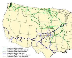
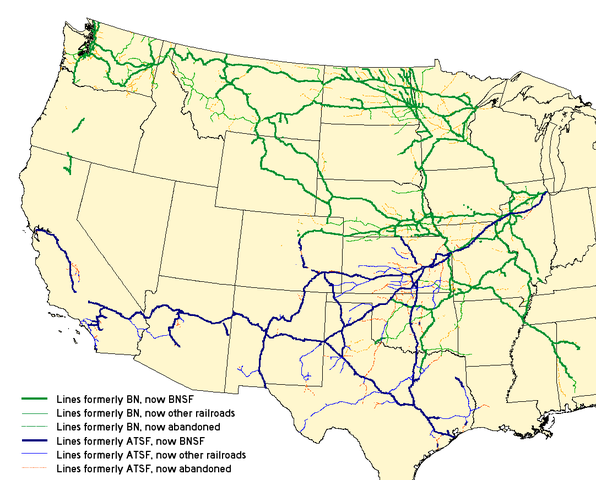
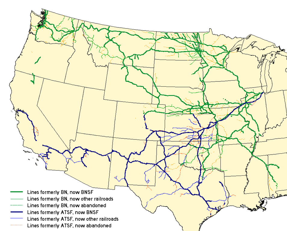
English: Map of the merger of the en:Burlington Northern Railroad and the en:Atchison, Topeka and Santa Fe Railway to form the en:BNSF Railway. See the map legend for details.
Created with Quantum GIS with data from the National Transportation Atlas Database. |
| Date | 3 September 2006 (original upload date) |
| Source |
Transferred from en.wikipedia to Commons by Quatro Valvole. |
| Author | The original uploader was Elkman at English Wikipedia. |
Licensing
[edit]
This file is licensed under the Creative Commons Attribution-Share Alike 2.5 Generic, 2.0 Generic and 1.0 Generic license.
- You are free:
- to share – to copy, distribute and transmit the work
- to remix – to adapt the work
- Under the following conditions:
- attribution – You must give appropriate credit, provide a link to the license, and indicate if changes were made. You may do so in any reasonable manner, but not in any way that suggests the licensor endorses you or your use.
- share alike – If you remix, transform, or build upon the material, you must distribute your contributions under the same or compatible license as the original.
| This file is licensed under the Creative Commons Attribution-Share Alike 3.0 Unported license. Subject to disclaimers. | ||
| ||
| This licensing tag was added to this file as part of the GFDL licensing update. |

|
Permission is granted to copy, distribute and/or modify this document under the terms of the GNU Free Documentation License, Version 1.2 or any later version published by the Free Software Foundation; with no Invariant Sections, no Front-Cover Texts, and no Back-Cover Texts. A copy of the license is included in the section entitled GNU Free Documentation License. Subject to disclaimers. |
Original upload log
[edit]
The original description page was here. All following user names refer to en.wikipedia.
- 2007-04-03 18:00 25or6to4 1082×872×8 (71630 bytes) Reverted to earlier revision
- 2007-04-03 17:59 25or6to4 1082×872×8 (60069 bytes) Reverted to earlier revision
- 2006-10-26 03:38 Elkman 1082×872×8 (71630 bytes) Map of the merger of the [[Burlington Northern Railroad]] and the [[Atchison, Topeka and Santa Fe Railway]] to form the [[BNSF Railway]]. See the map legend for details. Created with Quantum GIS with data from [http://www.bts.gov/publications/national_t
- 2006-09-03 18:53 Elkman 1082×872×8 (60069 bytes) Map of the merger of the [[Burlington Northern Railroad]] and the [[Atchison, Topeka and Santa Fe Railway]] to form the [[BNSF Railway]]. See the map legend for details. Created with Quantum GIS with data from [http://www.bts.gov/publications/national_t
File history
Click on a date/time to view the file as it appeared at that time.
| Date/Time | Thumbnail | Dimensions | User | Comment | |
|---|---|---|---|---|---|
| current | 06:45, 24 February 2008 | | 1,082 × 872 (70 KB) | Quatro Valvole (talk | contribs) | {{Information |Description={{en|Map of the merger of the en:Burlington Northern Railroad and the en:Atchison, Topeka and Santa Fe Railway to form the en:BNSF Railway. See the map legend for details. Created with Quantum GIS with data from |
You cannot overwrite this file.
File usage on Commons
The following 3 pages use this file:
File usage on other wikis
The following other wikis use this file:
- Usage on cy.wikipedia.org
- Usage on de.wikipedia.org
- Usage on en.wikipedia.org
- Usage on fi.wikipedia.org
- Usage on fr.wikipedia.org
- Usage on hu.wikipedia.org
- Usage on it.wikipedia.org
- Usage on ja.wikipedia.org
- Usage on nl.wikipedia.org
- Usage on no.wikipedia.org
- Usage on pt.wikipedia.org
- Usage on ru.wikipedia.org
- Usage on simple.wikipedia.org
- Usage on www.wikidata.org
- Usage on zh.wikipedia.org