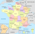
File:Baden-Württemberg, administrative divisions - de - colored.svg

Original file (SVG file, nominally 1,075 × 1,215 pixels, file size: 999 KB)
Captions
Captions
Summary
[edit]Licensing
[edit]- You are free:
- to share – to copy, distribute and transmit the work
- to remix – to adapt the work
- Under the following conditions:
- attribution – You must give appropriate credit, provide a link to the license, and indicate if changes were made. You may do so in any reasonable manner, but not in any way that suggests the licensor endorses you or your use.
- share alike – If you remix, transform, or build upon the material, you must distribute your contributions under the same or compatible license as the original.

|
Permission is granted to copy, distribute and/or modify this document under the terms of the GNU Free Documentation License, Version 1.2 or any later version published by the Free Software Foundation; with no Invariant Sections, no Front-Cover Texts, and no Back-Cover Texts. A copy of the license is included in the section entitled GNU Free Documentation License.http://www.gnu.org/copyleft/fdl.htmlGFDLGNU Free Documentation Licensetruetrue |

|
I'd greatly appreciate, that you attribute this media file to Wikimedia Commons, if used outside Wikipedia or Commons. For use in publications such as books, newspapers, blogs, websites, please insert here the following line:
বাংলা ∙ Deutsch ∙ Deutsch (Sie-Form) ∙ Ελληνικά ∙ English ∙ español ∙ français ∙ Ἀρχαία ἑλληνικὴ ∙ Bahasa Indonesia ∙ 日本語 ∙ македонски ∙ Nederlands ∙ português ∙ русский ∙ Türkçe ∙ 简体中文 ∙ 繁體中文 ∙ +/− |
File history
Click on a date/time to view the file as it appeared at that time.
| Date/Time | Thumbnail | Dimensions | User | Comment | |
|---|---|---|---|---|---|
| current | 23:37, 1 January 2013 |  | 1,075 × 1,215 (999 KB) | TUBS (talk | contribs) | |
| 12:26, 2 September 2012 |  | 1,075 × 1,215 (977 KB) | TUBS (talk | contribs) | == {{int:filedesc}} == {{Information |Description={{de|Karte der politischen Gliederung von XY (siehe Dateiname)}} {{en|Map of administrative divisions of XY (see filename)}} |Source={{own}}{{Adobe Illustrator}}{{Commonist}}{{AttribSVG|Baden-Wuerttemb... |
You cannot overwrite this file.
File usage on Commons
The following 2 pages use this file:
File usage on other wikis
The following other wikis use this file:
- Usage on als.wikipedia.org
- Usage on da.wikipedia.org
- Usage on de.wikipedia.org
- Baden-Württemberg
- Liste der Wappen in Baden-Württemberg
- Liste der Land- und Stadtkreise in Baden-Württemberg
- Vorlage:Imagemap Baden-Württemberg1
- Liste der Kulturdenkmale in Baden-Württemberg
- Wikipedia:Wiki Loves Earth/DE/Listen/BW/Baden-Württemberg
- Vorlage:Imagemap Baden-Württemberg verlinkbar
- Liste öffentlicher Bücherschränke in Baden-Württemberg
- Liste der Naturdenkmale in Baden-Württemberg
- Liste öffentlicher Kneipp-Anlagen in Baden-Württemberg
- Liste der Wasserschutzgebiete in Baden-Württemberg
- Liste der Geotope in Baden-Württemberg
- Benutzer:Triplec85/Topographische Karte von Baden-Württemberg 1:25000
- Liste von Sakralbauten in Baden-Württemberg
- Liste der Denkmäler des Deutsch-Französischen Krieges in Baden-Württemberg
- Liste der Gemarkungen in Baden-Württemberg
- Liste von Bergwerken in Baden-Württemberg
- Liste aktiver Brauereien in Baden-Württemberg
- Usage on es.wikipedia.org
- Usage on fi.wikipedia.org
- Usage on frr.wikipedia.org
- Usage on fr.wikipedia.org
- Usage on hu.wiktionary.org
- Usage on la.wikipedia.org
- Usage on stq.wikipedia.org
- Usage on www.wikidata.org
Metadata
This file contains additional information such as Exif metadata which may have been added by the digital camera, scanner, or software program used to create or digitize it. If the file has been modified from its original state, some details such as the timestamp may not fully reflect those of the original file. The timestamp is only as accurate as the clock in the camera, and it may be completely wrong.
| Width | 1075.23px |
|---|---|
| Height | 1215.42px |
Structured data
Items portrayed in this file
depicts
31 August 2012
image/svg+xml
3b55b3e85098246033c952d986969e5c54ba04b3
1,023,262 byte
1,215 pixel
1,075 pixel
- Vector images using elements from other vector images
- SVG labeled maps of administrative divisions (location map scheme) (all)
- Valid SVG created with Adobe Illustrator:Maps
- SVG created with Inkscape and Adobe Illustrator
- Uploaded with Commonist
- SVG maps:Translation possible
- CC-BY-SA-3.0
- License migration redundant
- GFDL
- Self-published work


