File:Balkans 1265.jpg
From Wikimedia Commons, the free media repository
Jump to navigation
Jump to search
Balkans_1265.jpg (600 × 422 pixels, file size: 75 KB, MIME type: image/jpeg)
File information
Structured data
Captions
Captions
Add a one-line explanation of what this file represents
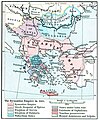
| DescriptionBalkans 1265.jpg | States in the Balkans in the 13th century (1265). The Historical Atlas, William R. Shepherd, 1911. | |||||
| Date | (UTC) | |||||
| Source | ||||||
| Author |
|
|||||
| Permission (Reusing this file) |
|
|||||
| Other versions |
 |
|||||
Original upload log
[edit]This image is a derivative work of the following images:
- File:ShepherdByzempire1265.jpg licensed with PD-old
- 2009-07-12T16:26:21Z Alex:D 1144x900 (287421 Bytes) whitened
- 2009-07-12T16:17:18Z Alex:D 1144x900 (287421 Bytes) whitened
- 2009-07-12T16:12:47Z Alex:D 1144x900 (287421 Bytes) whitened
- 2004-12-21T13:40:55Z Mschlindwein 1144x900 (278685 Bytes) Map, The Byzantine Empire, 1265. The Historical Atlas, William R. Shepherd, 1911.
Uploaded with derivativeFX
File history
Click on a date/time to view the file as it appeared at that time.
| Date/Time | Thumbnail | Dimensions | User | Comment | |
|---|---|---|---|---|---|
| current | 15:28, 16 November 2022 |  | 600 × 422 (75 KB) | Gyalu22 (talk | contribs) | You can't redraw the atlas |
| 15:24, 20 May 2016 |  | 748 × 900 (614 KB) | Julieta39 (talk | contribs) | Details : see discussion file | |
| 21:16, 27 January 2010 |  | 600 × 422 (75 KB) | Mladifilozof (talk | contribs) | {{Information |Description=States in the Balkans in the 13th century (1265). The Historical Atlas, William R. Shepherd, 1911. |Source=*File:ShepherdByzempire1265.jpg |Date=2010-01-27 21:14 (UTC) |Author=*File:ShepherdByzempire1265.jpg: William |
You cannot overwrite this file.
File usage on Commons
The following 2 pages use this file:
File usage on other wikis
The following other wikis use this file:
- Usage on be.wikipedia.org
- Usage on bg.wikipedia.org
- Usage on cs.wikipedia.org
- Usage on de.wikipedia.org
- Usage on el.wikipedia.org
- Usage on en.wikipedia.org
- Usage on et.wikipedia.org
- Usage on fa.wikipedia.org
- Usage on gl.wikipedia.org
- Usage on he.wikipedia.org
- Usage on hr.wikipedia.org
- Usage on id.wikipedia.org
- Usage on ie.wikipedia.org
- Usage on ja.wikipedia.org
- Usage on ko.wikipedia.org
- Usage on lt.wikipedia.org
- Usage on mk.wikipedia.org
- Usage on oc.wikipedia.org
- Usage on ro.wikipedia.org
- Usage on ru.wikipedia.org
- Usage on sh.wikipedia.org
- Usage on sl.wikipedia.org
- Usage on sq.wikipedia.org
- Usage on sr.wikipedia.org
- Usage on sv.wikipedia.org
- Usage on tr.wikipedia.org
- Usage on zh.wikipedia.org
Structured data
在此檔案描寫的項目
depicts
27 January 2010
image/jpeg
8233b35a422da365f14b5dde96a86fda8d77c0b8
76,504 byte
422 pixel
600 pixel
Categories:
- Maps showing history by William R. Shepherd
- Maps of the Byzantine Empire in the 13th century
- Maps showing 1265
- Maps of the Kingdom of Serbia (medieval)
- Maps of Serbia in the 13th century
- Maps of Bulgaria in the 13th century
- Maps of medieval Bosnian and neighboring states
- Maps of the history of Romania in the Middle Ages
- Romania in the 13th century
- Maps of Wallachia
- Banate of Severin
- Maps of Zeta in the Kingdom of Serbia
- Details of old history maps
