File:BayareaUSGS.jpg
Jump to navigation
Jump to search

Size of this preview: 578 × 600 pixels. Other resolutions: 231 × 240 pixels | 463 × 480 pixels | 769 × 798 pixels.
Original file (769 × 798 pixels, file size: 613 KB, MIME type: image/jpeg)
Captions
Captions
Add a one-line explanation of what this file represents
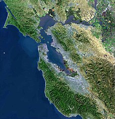
English: Satellite map of the San Francisco Bay Area of Northern California - from the U.S. Geological Survey.
- The effect of the San Andreas Fault on the terrain can been seen on a diagonal line from the upper left corner to the lower right. The green and golden mountainous regions (wrinkled in appearance) are largely uninhabited.
- The Golden Gate is the narrow connection between the San Francisco Bay (east and south of the entrance) and the Pacific Ocean (left). The northern part of the inland water is the San Pablo Bay, fed by Suisun Bay and the San Joaquin-Sacramento Delta.
- Directly south of the Golden Gate is the City and County of San Francisco, which is grey in appearance due to the high concentration of buildings and roads. The urban zone continues to Silicon Valley at the southern tip of the bay (bottom) and around to the East Bay.
- The green plots in the far upper right are the flat agricultural lands of a small part of the California Central Valley.
This image is in the public domain in the United States because it only contains materials that originally came from the United States Geological Survey, an agency of the United States Department of the Interior. For more information, see the official USGS copyright policy.
|
File history
Click on a date/time to view the file as it appeared at that time.
| Date/Time | Thumbnail | Dimensions | User | Comment | |
|---|---|---|---|---|---|
| current | 00:08, 19 April 2009 | | 769 × 798 (613 KB) | Yarnalgo (talk | contribs) | rmving little border on top and right and rmving USGS watermark |
| 15:14, 22 December 2006 |  | 770 × 800 (98 KB) | Nk (talk | contribs) | Satellite map of the San Francisco Bay Area from the U.S. Geological Survey. The effect of the San Andreas Fault on the terrain can been seen on a diagonal line from the upper left corner to the lower right. The green and golden mountainous regions (wri |
You cannot overwrite this file.
File usage on Commons
The following page uses this file:
File usage on other wikis
The following other wikis use this file:
- Usage on ar.wikipedia.org
- سان فرانسيسكو
- سان خوسيه (كاليفورنيا)
- مقاطعة ألاميدا (كاليفورنيا)
- مقاطعة كونترا كوستا (كاليفورنيا)
- مقاطعة مارين (كاليفورنيا)
- مقاطعة نابا (كاليفورنيا)
- مقاطعة سان ماتيو (كاليفورنيا)
- مقاطعة سانتا كلارا (كاليفورنيا)
- مقاطعة سولانو (كاليفورنيا)
- مقاطعة سونوما (كاليفورنيا)
- ستانفورد (كاليفورنيا)
- فاليجو (كاليفورنيا)
- نابا (كاليفورنيا)
- أوكلاند (كاليفورنيا)
- فريمونت (كاليفورنيا)
- هايوارد (كاليفورنيا)
- سان ماتيو (كاليفورنيا)
- ريدوود (كاليفورنيا)
- سانيفال (كاليفورنيا)
- سانتا كلارا (كاليفورنيا)
- سانتا روسا (كاليفورنيا)
- بيتالوما
- فيرفيلد (كاليفورنيا)
- مارتينز (كاليفورنيا)
- بنيسيا (كاليفورنيا)
- ريتشموند (كاليفورنيا)
- سان رافاييل (كاليفورنيا)
- أنتيوك
- منطقة خليج سان فرانسيسكو
- خليج سان فرانسيسكو
- ألاميدا (كاليفورنيا)
- ألباني (كاليفورنيا)
- أميريكان كانيون (كاليفورنيا)
- بيلمونت (كاليفورنيا)
- بيركيلي (كاليفورنيا)
- برينتوود (كاليفورنيا)
- بورلينغامي (كاليفورنيا)
- كامببيل (كاليفورنيا)
- كلايتون (كاليفورنيا)
- كونكورد (كاليفورنيا)
- كوبيرتينو (كاليفورنيا)
- دالي سيتي (كاليفورنيا)
- دانفيل (كاليفورنيا)
- ديكسون (كاليفورنيا)
- دوبلين (كاليفورنيا)
- إيست بالو ألتو (كاليفورنيا)
- إل سيرريتو (كاليفورنيا)
- إميريفيلي (كاليفورنيا)
- فوستير سيتي (كاليفورنيا)
- غيلروي (كاليفورنيا)
View more global usage of this file.