File:Berghaus Plan of Potsdam.jpg
Original file (3,000 × 2,533 pixels, file size: 3.18 MB, MIME type: image/jpeg)
Captions
Summary
[edit]Author |
creator QS:P170,Q67485 |
||||||||||||||||||||||||||
Description |
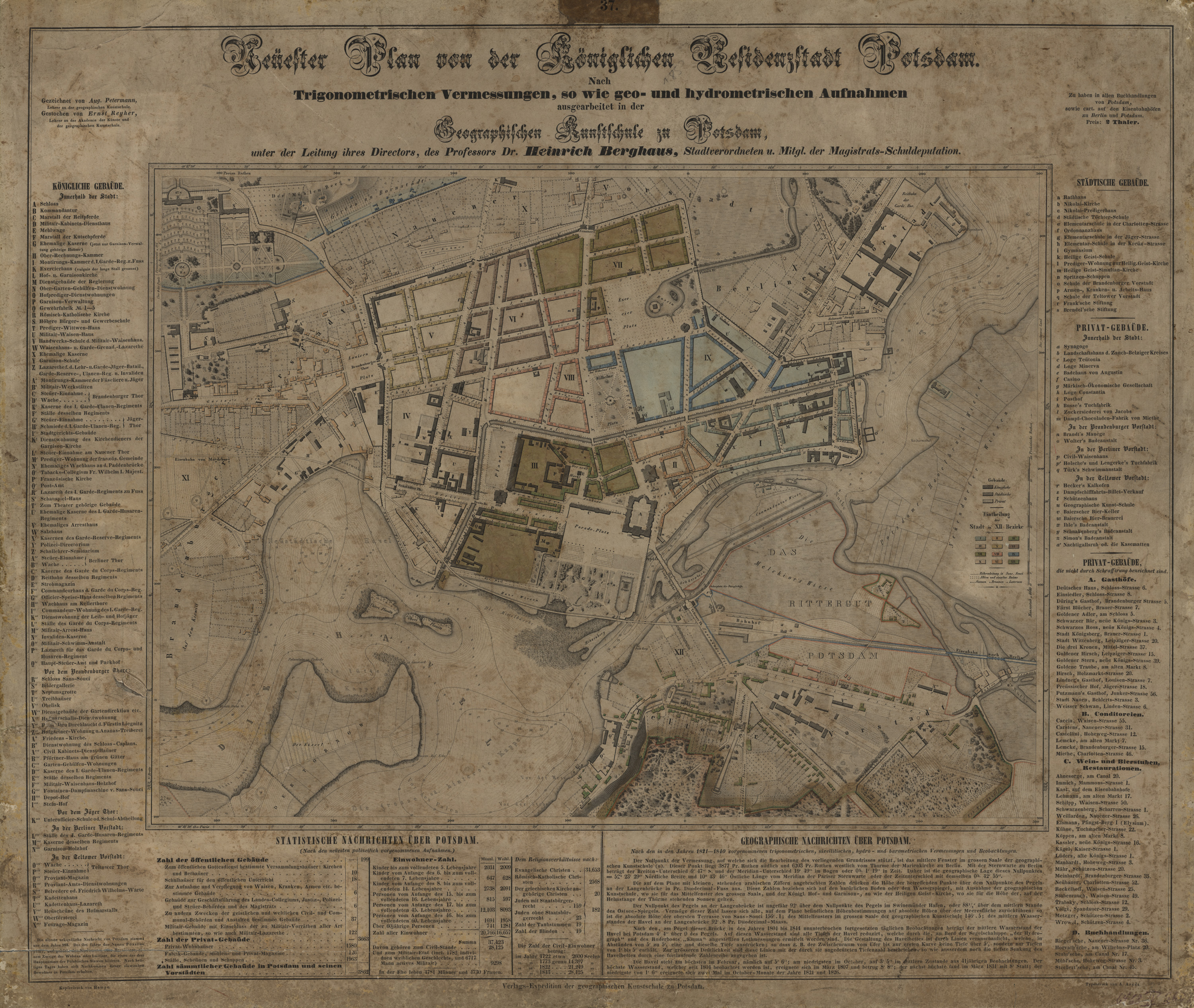
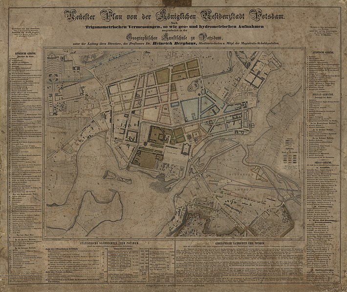
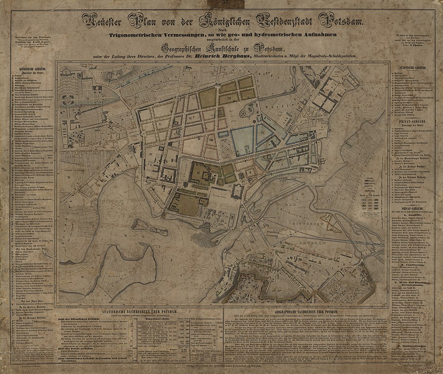
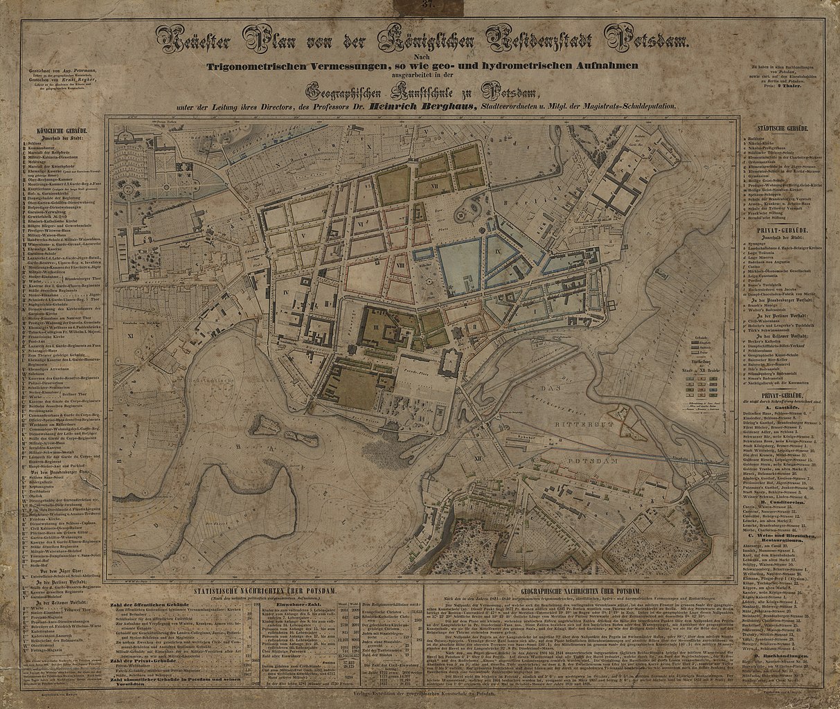
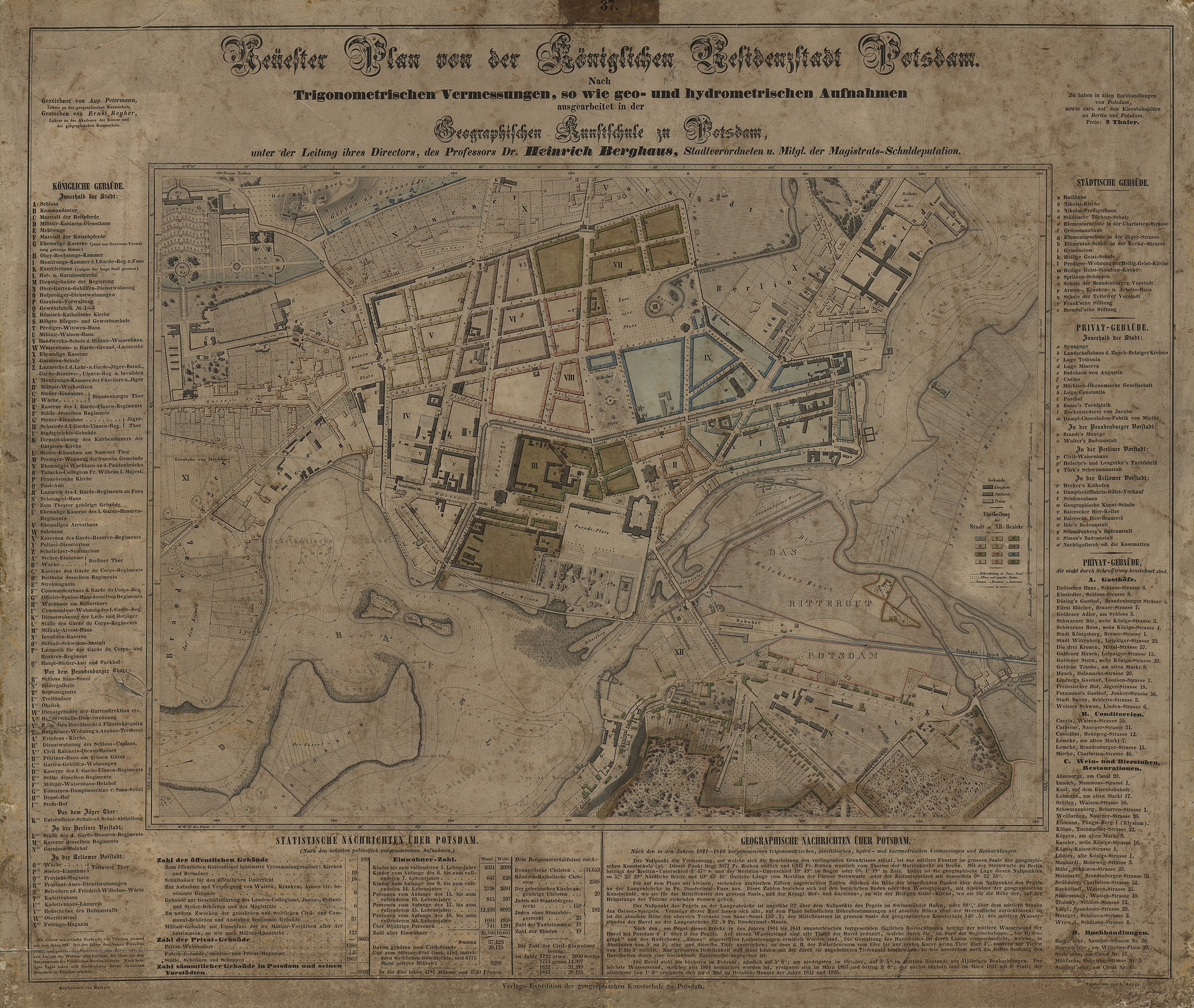
English: Map of Potsdam (detail), ca. 1850
Deutsch: "Neuester Plan von der königlichen Residenzstadt Potsdam", Dr. Heinrich Berghaus um 1850 (Ausschnitt) |
||||||||||||||||||||||||||
Date |
circa 1850 date QS:P571,+1850-00-00T00:00:00Z/9,P1480,Q5727902 |
||||||||||||||||||||||||||
Collection |
institution QS:P195,Q16320646 |
||||||||||||||||||||||||||
Source/Photographer | https://assets.museum-digital.org/brandenburg/images/201808/090915385b6c063a4bac8.jpg | ||||||||||||||||||||||||||
Permission (Reusing this file) |
PD § 68 UrhRG |
Licensing
[edit]
This is a faithful photographic reproduction of a two-dimensional, public domain work of art. The work of art itself is in the public domain for the following reason:
The official position taken by the Wikimedia Foundation is that "faithful reproductions of two-dimensional public domain works of art are public domain".
This photographic reproduction is therefore also considered to be in the public domain in the United States. In other jurisdictions, re-use of this content may be restricted; see Reuse of PD-Art photographs for details. |
File history
Click on a date/time to view the file as it appeared at that time.
Date/Time | Thumbnail | Dimensions | User | Comment | |
---|---|---|---|---|---|
current | 19:59, 28 October 2021 | 3,000 × 2,533 (3.18 MB) | Charlotte Heineccius (talk | contribs) | == {{int:filedesc}} == {{Artwork |Author = {{Creator:Heinrich Berghaus}} |Description ={{en|1=Map of Potsdam (detail), ca. 1850}} {{de|1="Neuester Plan von der königlichen Residenzstadt Potsdam", Dr. Heinrich Berghaus um 1850 (Ausschnitt)}} |Source =https://assets.museum-digital.org/brandenburg/images/201808/090915385b6c063a4bac8.jpg |Date ={{other date|~|1850}} |Permission = |other_versions = [https://brandenburg.museum-digital.de/index.php?t=objekt&oges=8861... |
You cannot overwrite this file.
File usage on Commons
The following 2 pages use this file:
Metadata
This file contains additional information such as Exif metadata which may have been added by the digital camera, scanner, or software program used to create or digitize it. If the file has been modified from its original state, some details such as the timestamp may not fully reflect those of the original file. The timestamp is only as accurate as the clock in the camera, and it may be completely wrong.
Camera manufacturer | Cruse Spezialmaschinen GmbH |
---|---|
Author | Digitalisierungslabor der FH Potsdam |
Image title | Der „Neueste Plan von der Königlichen Residenzstadt Potsdam“ entstand auf Grund einer Neuvermessung der Stadt. Schon im Untertitel wird der wissenschaftliche Anspruch der Urheber deutlich: „Nach / trigonometrischen Vermessungen, so wie geo- und hydrometrischen Aufnahmen / ausgearbeitet in der / Geografischen Kunstschule zu Potsdam, / unter der Leitung ihres Direktors, des Professors Dr. Heinrich Berghaus, Stadtverordneten u. Mitgl. der Magistrats-Schuldeputation.“ Heinrich Berghaus (1797–1884), einer der bedeutendsten preußischen Geografen und Kartografen des 19. Jahrhunderts, eröffnete 1839 eine private geografische Kunstschule in Potsdam. 1845 entstand diese präzise Aufnahme von Potsdam. Die Grafik umfasst einen Stadtplan von Potsdam und eine ausführliche Auflistung der königlichen, städtischen und privaten Gebäude innerhalb und außerhalb der Stadt. Des Weiteren informiert der Plan über den Ursprung der Stadt, die Einwohnerzahl nach Alter, Religion und Zivil- oder Militärstand sowie „geographische Nachrichten über Potsdam“. Einige der am Rand aufgeführten Informationen finden sich auch auf dem Plan selbst wieder: Die einzelnen Bezirke der Stadt sind durch Farben und römische Ziffern markiert. Durch leichte bis starke Schraffur wird angezeigt, ob es sich um ein privates, städtisches oder königliches Gebäude handelt. In der Havel ist durch Höhenlinien die Tiefe des Flussbettes vermerkt. Ein Raster mit der genauen geografischen Verortung und der Entfernung vom Null-Punkt, der Geografischen Kunstschule, ist am Rand eingezeichnet. Gezeichnet wurde das Blatt von August Petermann (1822–1878), einem Lehrer an der Geografischen Kunstschule, gestochen von Ernst Reyher (1788–1867), ebenfalls dort und an der Akademie der Künste Berlin unterrichtend. Zu einem Preis von zwei Talern konnte der Plan in Potsdam und Berlin erworben werden. Ein Faksimile des Plans befindet sich in der Ständigen Ausstellung des Potsdam Museums. [Sophie Schmidt] |
Credit/Provider | Potsdam Museum - Forum für Kuns |
Copyright holder | © Potsdam Museum - Forum für Kunst und Geschichte & Digitalisierungslabor der FH Potsdam ; Licence: CC BY-NC-SA (https://creat |
Short title | Neuester Plan von der Königlichen Residenzstadt Potsdam |
Source | museum-digital:brandenburg |
When re-using this work, please credit | Digitalisierungslabor der FH Potsdam |
URL for copyright license | https://creativecommons.org/licenses/by-nc-sa/4.0/ |
Copyright owner | Potsdam Museum - Forum für Kunst und Geschichte |
Usage terms |
|
JPEG file comment | Published via museum-digital:brandenburg; Canonical image url: https://brandenburg.museum-digital.de/singleimage.php?imagenr=19861 |
Width | 13,130 px |
Height | 9,149 px |
Bits per component |
|
Compression scheme | Uncompressed |
Pixel composition | RGB |
Orientation | Normal |
Number of components | 3 |
Horizontal resolution | 400 dpi |
Vertical resolution | 400 dpi |
Data arrangement | chunky format |
Software used | Adobe Photoshop Elements 13.0 (Windows) |
File change date and time | 10:19, 9 August 2018 |
Color space | Uncalibrated |
IIM version | 7,143 |
Keywords | Stadtplan, Residenzstadt |
Contact information | museum-geschichte@rathaus.potsdam.de
Am Alten Markt 9 Potsdam, , 14467 |
Date and time of digitizing | 14:14, 6 September 2013 |
Date metadata was last modified | 30 June 2019 |
Unique ID of original document | xmp.did:53183A0DDF16E3118613DC2EA3D17659 |