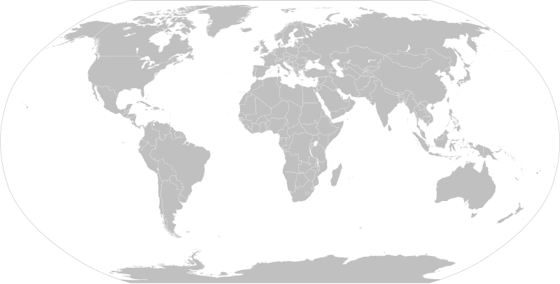
File:BlankMap-World.svg

Original file (SVG file, nominally 2,754 × 1,398 pixels, file size: 1.05 MB)
Captions
Captions

|
English: Editor's note:
Русский: Примечание редактора:
|

|
English: Note on boundaries: the map contains coding for various disputed sovereignty claims:
These classes can be changed in derivative maps by using CSS (see File_talk:BlankMap-World.svg#Selecting_and_colouring_countries on how to do that), but repeated overwriting of this file against established consensus might fall into COM:UPLOADWAR category and result in block. See instructions page for more details.Русский: Примечание по территориям: карта содержит в себе коды для территорий с нечётким правовым статусом, а именно:
Стандартное поведение этих территорий может, в производных работах, быть переопределено с помощью соответствующих CSS-классов (см. инструкцию (англ.), как это можно сделать), однако настойчивая перезапись данного файла вопреки устоявшемуся консенсусу может быть расценена как война загрузок и привести к блокировке. См. подробнее в документации файла (на англ.) |
This image should always reflect the most recent version. Feel free to update it when needed.
|

|
This file may be updated to reflect new information. If you wish to use a specific version of the file without it being overwritten, please upload the required version as a separate file. |
Summary
| DescriptionBlankMap-World.svg |
English: A detailed Robinson projection SVG map with grouping enabled to connect all non-contiguous parts of a country's territory for easy coloring. Smaller countries can also be represented by larger circles to show their data more clearly. A thorough description of use and other instructions relating to this can be found on the instructions page.
Русский: Современная политическая карта мира (бланк) в проекции Робинсона, сохранённая в векторном формате SVG, в котором территориально-разделённые части государств (острова, анклавы, заморские владения и другие) сгруппированы вместе — и таким образом легко окрашивать всю группу одним цветом. Малые страны, не отображающиеся или отображающиеся слишком мелко на карте мира в таком масштабе, на производных картах могут быть также отображены в виде кругов (на этой карте круги присутствуют в виде прозрачных невидимых элементов изображения). Более подробное описание и рекомендации по использованию смотрите в документации файла (англ.). |
|||
| Date | 12 November 2006 (original upload date) | |||
| Source | Adapted from File:"Political World" CIA World Factbook map 2005.svg which was originally based on CIA's 2005 political world map (a vector-based PDF file which can now be found in Perry–Castañeda Library Map Collection). | |||
| Author | Canuckguy (talk) and many others (see File history) | |||
| Permission (Reusing this file) |
|
|||
| Other versions |
Derivative works of this file:
|
|||
| SVG development InfoField |
|
| Blank maps of the world for historical use | |
| pre-1800 | |
|
19th century | |
|
20th century | |
|
1902 · 1912 · 1914 · WWI · Aug 1918 · 1920 · 1921 · 1924 · 1926 · 1935 · 1937 · Mar 1938 · Oct 1938 · Mar 1939 · Oct 1939 · WWII · Nov 1942 · May 1945 · 1957 · 1959 · 1962 · 1968 · 1970 · 1985 · 1990 · 1993 | |
|
21st century | |
| (this template: · view · discuss ) | |
File history
Click on a date/time to view the file as it appeared at that time.
| Date/Time | Thumbnail | Dimensions | User | Comment | |
|---|---|---|---|---|---|
| current | 09:25, 14 August 2021 |  | 2,754 × 1,398 (1.05 MB) | Seryo93 (talk | contribs) | Reverted to version as of 23:50, 11 August 2021 (UTC) messed-up again |
| 15:57, 12 August 2021 |  | 2,754 × 1,398 (1.05 MB) | Flackseven (talk | contribs) | Reverted to version as of 14:41, 8 August 2021 (UTC) | |
| 23:50, 11 August 2021 |  | 2,754 × 1,398 (1.05 MB) | Cherkash (talk | contribs) | using a 2-letter abbreviation (xr) for Kuril, just like the rest of them | |
| 17:14, 8 August 2021 |  | 2,754 × 1,398 (1.05 MB) | Seryo93 (talk | contribs) | changed Southern Kurile caption to match File:World_map_configurable.svg | |
| 17:00, 8 August 2021 |  | 2,754 × 1,398 (1.05 MB) | Seryo93 (talk | contribs) | +xsq class for the w:Kuril Islands dispute, following general scheme (grouped into controlling Russia) | |
| 16:27, 8 August 2021 |  | 2,754 × 1,398 (1.05 MB) | Seryo93 (talk | contribs) | Reverted to version as of 05:55, 8 August 2021 (UTC) see documentation and compare with Golans (internationally recognised as Syrian, yet grouped into Israel by default) | |
| 14:41, 8 August 2021 |  | 2,754 × 1,398 (1.05 MB) | Flackseven (talk | contribs) | Reverted to version as of 18:04, 7 August 2021 (UTC). Crimea must be connected to Ukraine. It cannot be on same layer with Russia by default. | |
| 05:55, 8 August 2021 |  | 2,754 × 1,398 (1.05 MB) | Seryo93 (talk | contribs) | The map must be customisable | |
| 18:04, 7 August 2021 |  | 2,754 × 1,398 (1.05 MB) | Flackseven (talk | contribs) | Reverted to version as of 22:47, 6 August 2021 (UTC). It is enough for pro-Russian users to edit the affiliation of Crimea. There should be no two classes, because Crimea must be inseparable with Ukraine, as it was before 2014. The map can be used by other people through search and can lead to a misconception about the affiliation of Crimea when they want to colorize and use it elsewhere.. | |
| 06:37, 7 August 2021 |  | 2,754 × 1,398 (1.05 MB) | Seryo93 (talk | contribs) | Reverted to version as of 16:36, 6 August 2021 (UTC) enough is enough, although Crimea is in a need for a solution. Maybe add it to both classes somehow? |
You cannot overwrite this file.
File usage on Commons
More than 100 pages use this file. The following list shows the first 100 pages that use this file only. A full list is available.
- Atlas of the early American societies
- Atlas of the early Asian societies
- Atlas of the early modern age
- Atlas of the world
- Maps of the world
- User:Estrabón
- User:Monaneko/押入れ
- Commons:Graphic Lab/Illustration workshop
- Commons talk:Project Mapmaking Wiki Standards/Archive01
- File:2006-2007 Global Competitiveness Index.svg
- File:2006Australian exports.svg
- File:2008 Global Champions Tour map.PNG
- File:2009 Global Champions Tour map.PNG
- File:2010 Global Champions Tour map.PNG
- File:ALD Automotive worldwide locations map.svg
- File:AOCWorldMap.svg
- File:African, Caribbean and Pacific Group of States member nations map.svg
- File:Agreement on the Conservation of African-Eurasian Migratory Waterbirds Parties.svg
- File:Agreement on the Conservation of Albatrosses and Petrels Parties.svg
- File:Armenia Japan Locator.svg
- File:Armenia Lebanon Locator.svg
- File:Beer Consumption by Country.svg
- File:Bern Convention.svg
- File:BlankMap-World-05082021.svg (file redirect)
- File:BlankMap-World-Compact.svg
- File:BlankMap-World-alt.png
- File:BlankMap-World-large.png
- File:BlankMap-World-noborders.png
- File:BlankMap-World-v5-BeforeKosovo.png
- File:BlankMap-World-v5.png
- File:BlankMap-World-v7.png
- File:BlankMap-World-with-Equator.svg
- File:BlankMap-World.svg
- File:BlankMap-World2.png
- File:BlankMap-World5.svg
- File:BlankMap-World6-NLCoastline.svg (file redirect)
- File:BlankMap-World6-png.png (file redirect)
- File:BlankMap-World6.svg (file redirect)
- File:BlankMap-World7.svg (file redirect)
- File:BlankMap-World8.svg (file redirect)
- File:BlankMap-World 5004x2540.png (file redirect)
- File:BlankMap-World Default Edition.svg (file redirect)
- File:CIVETS.svg
- File:CoE conventions external invitations.svg
- File:Criminalization of marital rape map.svg
- File:DAC members.svg
- File:EU special territories (en).svg
- File:Egypt Libya Locator.png
- File:Egypt Mongolia Locator.png
- File:Emergency ngo countries.png
- File:Emergency ngo countries.svg
- File:Ethiopia People's Republic of China Locator.png
- File:European Neighbourhood Policy member map.svg
- File:Extended Central America.svg
- File:G8countries.svg
- File:Global Competitiveness Index 2008-2009.svg
- File:Gorilla Agreement Parties de.svg
- File:IASTA-2007-map.svg
- File:ICAC Map-World.png
- File:IPTV-Countries.svg
- File:Intergovernmental Council of Copper Exporting Countries member states map.svg
- File:International Telecommunication Union region.svg
- File:Island nations.svg
- File:Jetstar Airways international and domestic destinations.svg
- File:Jus soli world.svg
- File:Life Expectancy 2008 Estimates CIA World Factbook.svg
- File:Life Expectancy 2009 Estimates CIA World Factbook.svg
- File:Main religion by country - World map.svg
- File:Map of world by beer consumption.png
- File:Mercosul.svg
- File:Montenegro Ukraine Locator.png
- File:Nations recognising the Armenian Genocide.svg
- File:OSCE members and partners.svg
- File:Passermontanusmap.png
- File:Pinguicula alpina distribution.svg
- File:Qantas Airways international and domestic destinations.svg
- File:RedCross MagenDavid RedCresent.svg
- File:RuneScape server locations.svg
- File:SJA-WorldMap.svg
- File:UN Human Development Report 2008.svg
- File:Ukrainian lang.svg
- File:Universal Postal Union member states.svg
- File:Vikihaber Afganistan-logo.svg
- File:Vikihaber Almanya-logo.svg
- File:Vikihaber Azerbaycan-logo.svg
- File:Vikihaber Brezilya-logo.svg
- File:Vikihaber Ermenistan-logo.svg
- File:Vikihaber Gürcistan-logo.svg
- File:Vikihaber Irak-logo.svg
- File:Vikihaber Japonya-logo.svg
- File:Vikihaber Kıbrıs-logo.svg
- File:Vikihaber Meksika-logo.svg
- File:Vikihaber Pakistan-logo.svg
- File:Vikihaber Suriye-logo.svg
- File:Vikihaber Türkiye-logo.svg
- File:Vikihaber Yunanistan-logo.svg
- File:Vikihaber Çin Halk Cumhuriyeti-logo.svg
- File:Vikihaber İran-logo.svg
- File:Visitas de Juan Manuel Santos.svg
- File:Wkipedia blank world map.jpg
View more links to this file.
File usage on other wikis
The following other wikis use this file:
- Usage on ar.wikipedia.org
- تومب ريدر (سلسلة)
- منظمة الإغاثة الإسلامية
- تصنيف:حيوانات حسب القارة
- مؤسسة محمد بن سلمان
- بطولات العالم للدراجات
- قالب:International cycling
- تصنيف:فرق ركوب الدراجات
- ركوب الدراجات في الألعاب الأولمبية الصيفية
- يو سي آي برو سيريس
- ركوب الدراجات في الألعاب البارالمبية الصيفية
- بطولة العالم للدراجات على المضمار لذوي الاحتياجات الخاصة
- Usage on ast.wikipedia.org
- Usage on be-tarask.wikipedia.org
- Usage on be.wikipedia.org
- Катэгорыя:Геаграфія паводле кантынентаў
- Катэгорыя:Астравы паводле акіянаў
- Шаблон:Спасылкі паводле кантынентаў
- Катэгорыя:Флора паводле кантынентаў
- Катэгорыя:Рыбы паводле рэгіёнаў
- Катэгорыя:Фаўна паводле кантынентаў
- Катэгорыя:Адміністрацыйны падзел краін паводле кантынентаў
- Катэгорыя:Эндэмікі Еўразіі
- Катэгорыя:Эндэмікі паводле кантынентаў
- Катэгорыя:Эндэмікі Паўночнай Амерыкі
- Катэгорыя:Эндэмікі Паўднёвай Амерыкі
- Usage on bg.wikipedia.org
- Usage on bn.wikipedia.org
- Usage on bn.wikibooks.org
- Usage on bpy.wikipedia.org
View more global usage of this file.
Metadata
This file contains additional information such as Exif metadata which may have been added by the digital camera, scanner, or software program used to create or digitize it. If the file has been modified from its original state, some details such as the timestamp may not fully reflect those of the original file. The timestamp is only as accurate as the clock in the camera, and it may be completely wrong.
| Short title | World Map |
|---|---|
| Width | 2754 |
| Height | 1398 |


