File:BokoHaraminsurgency.png
Jump to navigation
Jump to search
Size of this preview: 548 × 599 pixels. Other resolutions: 219 × 240 pixels | 439 × 480 pixels | 702 × 768 pixels | 936 × 1,024 pixels | 1,848 × 2,021 pixels.
Original file (1,848 × 2,021 pixels, file size: 332 KB, MIME type: image/png)
Captions
Captions
Add a one-line explanation of what this file represents
Summary
[edit]
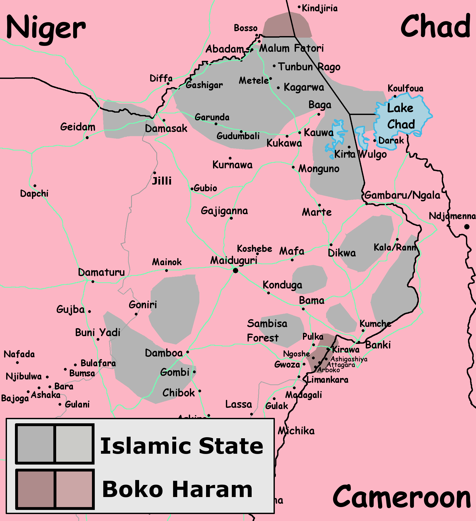
| Description | Map of Boko Haram insurgency in June 2022 |
| Date | |
| Source | Own work. Insurgent controlled areas are based on sum of these maps by Tomasz Rolbiecki, an analyst at the security firm ExTrac: [1], [2], [3], [4]. After Battle of Sambisa Forest in 2021 ISIS took control of most Boko Haram-held areas, except for two: Bakura group operating in Lake Chad and group operating in Mandara mountains near border with Chad (source). Both shown on the map. |
| Author | Borysk5 |
| Permission (Reusing this file) |
This file is licensed under the Creative Commons Attribution-Share Alike 4.0 International license.
|
File history
Click on a date/time to view the file as it appeared at that time.
| Date/Time | Thumbnail | Dimensions | User | Comment | |
|---|---|---|---|---|---|
| current | 07:39, 13 June 2022 | | 1,848 × 2,021 (332 KB) | Borysk5 (talk | contribs) | {{Information |Description=Map of Boko Haram insurgency in June 2022 |Source={{own}}. Insurgent controlled areas are based on sum of these maps by Tomasz Rolbiecki, an analyst at the security firm ExTrac: [https://www.google.com/maps/d/u/0/viewer?mid=1v9JRNQ9BMwDHwPw6XRf2fuT1MoieFRHR&ll=12.218790016926228%2C13.291653324424303&z=8], [https://twitter.com/TomaszRolbiecki/status/1136585268935499777], [https://twitter.com/TomaszRolbiecki/status/1490674725693104133], [https://twitter.com/TomaszRolb... |
You cannot overwrite this file.
File usage on Commons
More than 100 pages use this file. The following list shows the first 100 pages that use this file only. A full list is available.
- User:Hermes79
- User:Hermes7979
- File:2013 Hama Offensive.svg
- File:2015 Latakia Frontlines.svg
- File:Aleppo Offensives 2015.svg
- File:Armed conflict zones in Myanmar.png
- File:Attaques-terroristes-meurtrières-au-21eme-siecle.png
- File:Battle of Daraa City.svg
- File:Battle of Hasakah.svg
- File:Battle of Qamishli.svg
- File:Battle of Raqqa.svg
- File:Battle of Tadmur.svg
- File:Battle of Western Qalamoun.svg
- File:Battlefields in The Global War on Terror.svg
- File:Battlefields in The Global War on Terror - edit03.png
- File:Battlefields in The Global War on Terror - edit04.png
- File:Benghazi Conflict Detailed Map.png
- File:Benghazi Conflict Detailed Map.svg
- File:Boko Haram insurgency map.svg
- File:Countries by soldier count.svg
- File:Deir ez-Zor clashes (2017).svg
- File:East Congo conflict map.svg
- File:GSPC map.png
- File:ISIS (Grey) Territory Change 2014-2016.gif
- File:Iraqi Civil War map (2014–present).png
- File:Iraqi–Kurdish conflict map.png
- File:Islamist insurgency in Nigeria.svg
- File:Lebanese insurgency.png
- File:Lebanese insurgency.svg
- File:Libyan Civil War.svg
- File:Libyan war final-fr.svg
- File:Map of Ongoing conflicts around the world.png
- File:Map of terror of the Islamic State (ad-Daula al-islāmiyya).png
- File:Mexico states map small war.PNG
- File:Mosul offensive (2015) map.png
- File:Number of Terrorist Incidents.png
- File:Ongoing Conflicts (1).png
- File:Ongoing conflicts around the world.svg
- File:Pakistan-Waziristan-Map.png
- File:Political map Afar triangle.png
- File:Rif Damashq.svg
- File:Siege of Homs Map.svg
- File:Sinai insurgency.svg
- File:Somali Civil War (2009-present).svg
- File:Southern Sudan Civil War.svg
- File:Sudanese Internal Conflict.svg
- File:Syria and Iraq 2014-onward War map.png
- File:Syrian, Iraqi, and Lebanese insurgencies.png
- File:Syrian Civil War map.svg
- File:Syrian civil war.png
- File:Tadmur offensive (2015).jpg
- File:Territorial changes after 2016 Armenian-Azerbaijani clashes.jpg
- File:Turkish-PKK rebellion.svg
- File:War in North-West Pakistan.svg
- File:World2s.png
- File:Yemeni Civil War.svg
- File:Zones de conflit en Birmanie.png
- File:Саудовско-йеменский конфликт.png
- Template:Ongoing civil wars (maps)
- Category:2015 military intervention in Yemen
- Category:2016 Armenian–Azerbaijani clashes
- Category:Attack
- Category:Battle of Aleppo
- Category:Battles in 2016
- Category:Battles of Syria
- Category:Battles of the Syrian Civil War
- Category:Civil wars
- Category:Conflicts
- Category:Conflicts by continent
- Category:Conflicts by country
- Category:Conflicts by type
- Category:Current civil wars maps
- Category:Feuds
- Category:Fights
- Category:Liberation of Palmyra (2016)
- Category:Maps of Somali Civil War
- Category:Maps of conflicts
- Category:Maps of disputed territories
- Category:Maps of terrorism
- Category:Maps of the 2014 pro-Russian unrest in Ukraine
- Category:Maps of the Demilitarized Zone of Korea
- Category:Maps of the Syrian Civil War in 2016
- Category:Maps of the Syrian Civil War in 2017
- Category:Maps of the War in Afghanistan (2001–2021)
- Category:Maps of wars
- Category:Military conflicts
- Category:Military maps of the world
- Category:Ongoing armed conflicts
- Category:Palmyra offensive (December 2016)
- Category:Quarrels
- Category:Rebellions
- Category:Riots
- Category:Schisms
- Category:Syrian Civil War
- Category:Terrorism
- Category:Uprisings
- Category:War
- Category:War casualties
- Category:Warfare by type
- Category:Wars
.svg)
_Territory_Change_2014-2016.gif)
.png)
.png)
_map.png)
.png)
.svg)
.jpg)
View more links to this file.
File usage on other wikis
The following other wikis use this file:
- Usage on en.wikipedia.org
- Usage on es.wikipedia.org
- Usage on ha.wikipedia.org
- Usage on he.wikipedia.org
- Usage on hu.wikipedia.org
- Usage on ig.wikipedia.org
- Usage on ru.wikipedia.org
- Usage on sd.wikipedia.org
- Usage on si.wikipedia.org