File:Brahmaputra-verlaufsgebiet.jpg
Jump to navigation
Jump to search

Size of this preview: 800 × 523 pixels. Other resolutions: 320 × 209 pixels | 640 × 418 pixels | 1,024 × 669 pixels | 1,280 × 836 pixels.
Original file (1,280 × 836 pixels, file size: 296 KB, MIME type: image/jpeg)
Captions
Captions
Add a one-line explanation of what this file represents
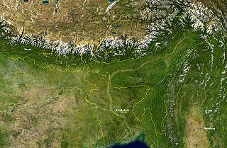
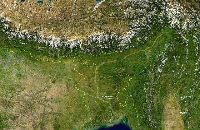
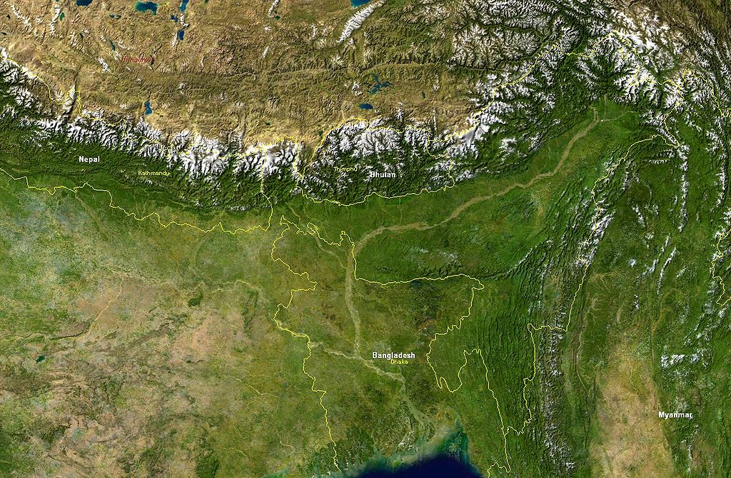
Verlaufsgebiet des Brahmaputra.
Aufnahme der "Blue Marble" (MODIS) mit eingezeichneten Staatsgrenzen, Staatsbezeichnungen, wichtige Städten sowie der Beschriftung "Himalaya".
| This file is in the public domain in the United States because it was solely created by NASA. NASA copyright policy states that "NASA material is not protected by copyright unless noted". (See Template:PD-USGov, NASA copyright policy page or JPL Image Use Policy.) | ||
 |
Warnings:
|
File history
Click on a date/time to view the file as it appeared at that time.
| Date/Time | Thumbnail | Dimensions | User | Comment | |
|---|---|---|---|---|---|
| current | 16:36, 29 November 2004 | | 1,280 × 836 (296 KB) | MartinaRoell (talk | contribs) | Verlaufsgebiet des Brahmaputra |
You cannot overwrite this file.
File usage on Commons
The following 2 pages use this file:
File usage on other wikis
The following other wikis use this file:
- Usage on as.wikipedia.org
- Usage on ba.wikipedia.org
- Usage on bn.wikipedia.org
- Usage on bo.wikipedia.org
- Usage on cs.wikipedia.org
- Usage on da.wikipedia.org
- Usage on es.wikipedia.org
- Usage on et.wikipedia.org
- Usage on fr.wikipedia.org
- Usage on he.wikipedia.org
- Usage on hu.wikipedia.org
- Usage on id.wikipedia.org
- Usage on is.wikipedia.org
- Usage on it.wikipedia.org
- Usage on ja.wikipedia.org
- Usage on jv.wikipedia.org
- Usage on km.wikipedia.org
- Usage on kn.wikipedia.org
- Usage on lmo.wikipedia.org
- Usage on ml.wikipedia.org
- Usage on nn.wikipedia.org
- Usage on pl.wikipedia.org
- Usage on pt.wikipedia.org
- Usage on ru.wikipedia.org
- Usage on sl.wikipedia.org
- Usage on sv.wikipedia.org
- Usage on ta.wikipedia.org
- Usage on te.wikipedia.org
- Usage on uk.wikipedia.org
- Usage on vi.wikipedia.org
- Usage on xmf.wikipedia.org
- Usage on zh.wikipedia.org
Metadata
Categories:
- Maps of the Brahmaputra
- NASA MODIS images of Asia
- Satellite pictures of rivers
- Satellite pictures of Bangladesh
- Satellite pictures of Bhutan
- Satellite pictures of Tibet
- Satellite pictures of West Bengal
- Satellite pictures of Myanmar
- Satellite pictures of Nepal
- Blue Marble 2002 images
- Topography of Bangladesh
- Topographic maps of Bhutan
- Yamdrok Lake