File:COVID-19 Outbreak Cases in Germany Kreise.svg

Original file (SVG file, nominally 947 × 1,253 pixels, file size: 772 KB)
Captions
Captions
Summary
[edit]
| Description |
English: {|class="description en" lang="en" style="margin:0.5em auto;width:100%;border:1px solid #ABD5F5;background:white"
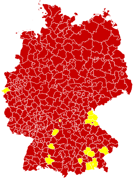
|+style="text-align:center;"|English (en): Map of the COVID-19 outbreak in Germany as of 14 March 2020. Be aware that since this is a rapidly evolving situation, new cases may not be immediately represented visually. Refer to the primary article 2019–20 coronavirus outbreak or the World Health Organization's situation reports for most recent reported case information. |- | Confirmed cases reported Especially affected areas (Besonders betroffene Gebiete), as defined by RKI
|} |
| Date | |
| Source |
Derived from File:Landkreise, Kreise und kreisfreie Städte in Deutschland 2011-09-04.svg by User:TUBS For full sources, see 2020 coronavirus outbreak in Germany#Timeline or COVID-19-Fälle in Deutschland#Verlauf; additionally current reliable media reports are incorporated - see change log of this file for details
|
| Author | Smurrayinchester |
| SVG development |
Licensing
[edit]
- You are free:
- to share – to copy, distribute and transmit the work
- to remix – to adapt the work
- Under the following conditions:
- attribution – You must give appropriate credit, provide a link to the license, and indicate if changes were made. You may do so in any reasonable manner, but not in any way that suggests the licensor endorses you or your use.
- share alike – If you remix, transform, or build upon the material, you must distribute your contributions under the same or compatible license as the original.
File history
Click on a date/time to view the file as it appeared at that time.
| Date/Time | Thumbnail | Dimensions | User | Comment | |
|---|---|---|---|---|---|
| current | 16:13, 30 March 2020 | | 947 × 1,253 (772 KB) | LSE Wendland (talk | contribs) | Risikogebiete ergänzt |
| 09:25, 21 March 2020 |  | 947 × 1,253 (771 KB) | FelixL. (talk | contribs) | Updated: Zweibrücken, Pirmasens, Hildburghausen and Lüchow-Dannenberg | |
| 20:15, 20 March 2020 |  | 947 × 1,253 (761 KB) | FelixL. (talk | contribs) | New version now SVG | |
| 18:08, 20 March 2020 |  | 947 × 1,253 (706 KB) | Cush (talk | contribs) | Reverted to version as of 10:12, 18 March 2020 (UTC) The new files is not a real SVG but a PNG placed inside an SVG | |
| 15:30, 20 March 2020 |  | 947 × 1,253 (764 KB) | FelixL. (talk | contribs) | Updated (https://experience.arcgis.com/experience/478220a4c454480e823b17327b2bf1d4/page/page_1/) | |
| 10:12, 18 March 2020 |  | 947 × 1,253 (706 KB) | Smurrayinchester (talk | contribs) | Fill in some gaps using RKI data https://www.rki.de/DE/Content/InfAZ/N/Neuartiges_Coronavirus/Situationsberichte/2020-03-17-en.pdf?__blob=publicationFile | |
| 10:01, 18 March 2020 |  | 947 × 1,253 (706 KB) | Smurrayinchester (talk | contribs) | Update (+ LK Ansbach, Birkenfeld, Frankfurt (Oder), Gotha, Landau-Pfalz, Mittelsachsen, Mühldorf (Inn), Südwestpfalz, Trier-Saarburg, Unterallgäu, Unstrut-Hainich-Kreis, Wartburgkreis). Data for the NDR area has not been updated since Sunday | |
| 16:35, 16 March 2020 |  | 947 × 1,253 (705 KB) | Smurrayinchester (talk | contribs) | Update (+ Aischach-Friedberg, Amberg, Bamberg, Brandenburg (Havel), Dachau, Dessau-Roßlau, Eichsfeld, Eisenach, Greiz, Höxter, Jena, Kulmbach, Landau-in-der-Pfalz, Lichtenfels, Limburg-Weilburg, Odenwald, Regen, LK Stendal, Suhl, Unterallgäu, Weimarer Land, Werra-Meißner, Wunseidel i. Fichtelgebirge) | |
| 09:59, 15 March 2020 |  | 947 × 1,253 (705 KB) | Smurrayinchester (talk | contribs) | Update +(Altenkirchen (Westerwald), Darmstadt, Erlangen-Hochstadt, Kusel, Ludwigslust-Parchim, Nürnburg, Potsdam, Rhein-Hunsrück, Südliche Weinstraße, Tuttlingen, Würzburg). Not clear whether all states have updated over the weekend. | |
| 16:05, 14 March 2020 |  | 947 × 1,253 (705 KB) | Smurrayinchester (talk | contribs) | Update + Ahrweiler, Altenburger Land, Alzey-Worms, LK Aschaffenburg, Bad Kreuznach, Bad Tölz, Barnim, Cochem-Zell, Dahme-Spreewald, Eichstätt, Frankenthal (Pfalz), Gifhorn, Goslar, Hamm, Haßberge, Heidekreis, Helmstedt, Jerichower Land, Kaufbeuren, Krefeld, Kronach, Landshut (Stadt), Ludwigshafen (Rhein), Memmingen (Stadt), Miltenberg, LK Neustadt a.d.Waldnaab, Nordfriesland, Nordhausen, Nordsachsen, Northeim, Osnabrück (Stadt), Passau (Stadt), Potsdam-Mittelmark, Regen, Rhein-Pfalz, Rosenhei... |
You cannot overwrite this file.
File usage on Commons
The following page uses this file:
File usage on other wikis
The following other wikis use this file:
- Usage on ar.wikipedia.org
- Usage on fa.wikipedia.org
- Usage on ja.wikipedia.org
- Usage on uk.wikipedia.org
- Usage on vi.wikipedia.org
- Usage on www.wikidata.org