File:Carte Bangladesh.png
From Wikimedia Commons, the free media repository
Jump to navigation
Jump to search
Carte_Bangladesh.png (340 × 370 pixels, file size: 43 KB, MIME type: image/png)
File information
Structured data
Captions
Captions
Add a one-line explanation of what this file represents
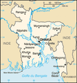
Carte du Bangladesh / CIA Facts Book
| Public domainPublic domainfalsefalse |
This image is in the public domain because it contains materials that originally came from the United States Central Intelligence Agency's World Factbook.
Bahasa Indonesia ∙ čeština ∙ Deutsch ∙ eesti ∙ English ∙ español ∙ Esperanto ∙ français ∙ galego ∙ hrvatski ∙ italiano ∙ Nederlands ∙ norsk nynorsk ∙ polski ∙ português ∙ sicilianu ∙ slovenščina ∙ suomi ∙ Türkçe ∙ Zazaki ∙ беларуская (тарашкевіца) ∙ македонски ∙ русский ∙ српски / srpski ∙ українська ∙ ქართული ∙ বাংলা ∙ தமிழ் ∙ മലയാളം ∙ 한국어 ∙ 日本語 ∙ 中文 ∙ 中文(简体) ∙ 中文(繁體) ∙ العربية ∙ +/− |
 |
File history
Click on a date/time to view the file as it appeared at that time.
| Date/Time | Thumbnail | Dimensions | User | Comment | |
|---|---|---|---|---|---|
| current | 14:18, 29 September 2006 |  | 340 × 370 (43 KB) | Loveless (talk | contribs) | This image was copied from wikipedia:fr. The original description was: Carte du Bangladesh / CIA Facts Book {{Atelier graphique carte}} Statut : {{DomainePublic}} fr:Catégorie:Cartes du Bangladesh {| border="1" ! date/time || username || resolu |
| 20:16, 16 October 2005 |  | 330 × 354 (48 KB) | Shaka (talk | contribs) | Carte du Bangladesh / CIA Facts Book {{PD}} Category:Dhaka |
You cannot overwrite this file.
File usage on Commons
The following page uses this file:
File usage on other wikis
The following other wikis use this file:
- Usage on ca.wikipedia.org
- Usage on fr.wikipedia.org
- Usage on gd.wikipedia.org
- Usage on is.wikipedia.org
- Usage on it.wikipedia.org
- Usage on oc.wikipedia.org
- Usage on roa-tara.wikipedia.org
- Usage on sw.wikipedia.org
- Usage on ta.wikipedia.org
