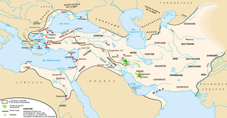
File:Carte empire achéménide.png

Original file (1,766 × 914 pixels, file size: 549 KB, MIME type: image/png)
Captions
Captions
Summary
[edit]| Description |
Licensing[edit]I, the copyright holder of this work, hereby publish it under the following license: This file is licensed under the Creative Commons Attribution-Share Alike 2.5 Generic, 2.0 Generic and 1.0 Generic license.
|
||||||||||
|
|
Note : Description : |
||||||||||


- See also English version: Image:Map achaemenid empire en.png
- See also Hungarian svg version: image:Map achaemenid empire hu.svg
File history
Click on a date/time to view the file as it appeared at that time.
| Date/Time | Thumbnail | Dimensions | User | Comment | |
|---|---|---|---|---|---|
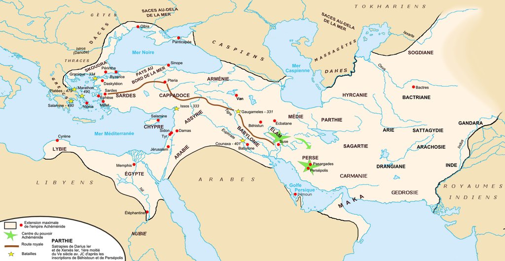
| current | 11:40, 30 April 2017 | | 1,766 × 914 (549 KB) | Mélomène (talk | contribs) | Little corrections and details since H.E. Unger's (dir.) « Westermann Grosser Atlas zur Weltgeschichte », Braunschweig 1985, ISBN 3-14-100919-8, pp. 14, 15, 22, 23. Shorelines of the period. |
| 23:18, 24 August 2006 |  | 1,766 × 914 (524 KB) | Fabienkhan (talk | contribs) | <div style="height:8px; border:1px solid #8898BF; -moz-border-radius-topleft:8px; -moz-border-radius-topright:8px; background:#C8D8FF; font-size:1px;"> </div> <div style="margin-bottom:1.5em; border:1px solid #8898BF; border-top:0; padding:5px; background |
You cannot overwrite this file.
File usage on Commons
The following 21 pages use this file:
- Atlas of Azerbaijan
- Atlas of Cyprus
- Atlas of Egypt
- Atlas of Greece
- Atlas of Iran
- Atlas of Iraq
- Atlas of Israel
- Atlas of Jordan
- Atlas of Kuwait
- Atlas of Kyrgyzstan
- Atlas of Lebanon
- Atlas of Northern Cyprus
- Atlas of Palestine
- Atlas of Syria
- Atlas of Tajikistan
- Atlas of Turkey
- Atlas of Turkmenistan
- Atlas of Uzbekistan
- File:Map achaemenid empire ca.svg
- File:Map achaemenid empire en.png
- Template:Other versions/Map achaemenid empire
File usage on other wikis
The following other wikis use this file:
- Usage on da.wikipedia.org
- Usage on eu.wikipedia.org
- Usage on fa.wikipedia.org
- Usage on fa.wikibooks.org
- Usage on fr.wikipedia.org
- Antiquité
- Bactriane
- Années 490 av. J.-C.
- Achéménides
- Guerres médiques
- Pourim
- Colchide
- Histoire de la Géorgie
- Histoire de l'Iran
- Persépolis
- Histoire de l'Ouzbékistan
- Histoire de l'Azerbaïdjan
- Royaumes indo-grecs
- Histoire de la Mésopotamie
- Gouvernement mondial
- Histoire de la Jordanie
- Margiane
- Atropatène
- Histoire de l'Asie centrale
- Proche-Orient ancien
- Portail:Proche-Orient ancien
- Portail:Iran et monde iranien/Lumière sur.../Archives
- Pont (région)
- Utilisateur:Zunkir/POA autres
- Histoire de l'Élam
- Babylonie tardive
- Portail:Proche-Orient ancien/Carte
- Portail:Proche-Orient ancien/Carte/5
- Satrapie de Bactriane
- Satrapie de Perside
- Utilisateur:Apollonidès/Galerie
- Calendrier cappadocien
- Utilisateur:Stefan Ivanovich/Royaumes indo-grecs
- Usage on it.wikipedia.org
- Usage on ja.wikipedia.org
- Usage on mg.wikipedia.org
- Usage on ml.wikipedia.org
- Usage on pl.wikipedia.org
- Usage on pt.wikipedia.org
- Usage on sq.wikipedia.org
View more global usage of this file.