File:Ce-map - 2.png
Jump to navigation
Jump to search
No higher resolution available.
Ce-map_-_2.png (330 × 353 pixels, file size: 19 KB, MIME type: image/png)
Captions
Captions
Add a one-line explanation of what this file represents
Summary
[edit]| Description |
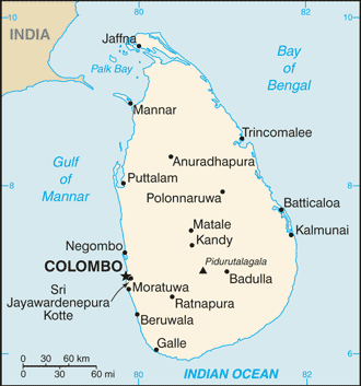
English: From the 2012 CIA World Fact Book |
| Date | |
| Source | https://www.cia.gov/library/publications/the-world-factbook/maps/maptemplate_ce.html |
| Author | CIA |
| Other versions |
[]
|


.png)


Licensing
[edit]
This image is in the public domain because it contains materials that originally came from the United States Central Intelligence Agency's World Factbook.
|
 |
Original upload log
[edit]
| Date/Time | Dimensions | User | Comment |
|---|---|---|---|
| 6 September 2012, 03:18:00 | 330 × 353 (16468 bytes) | Thricecube (talk · contribs) | User created page with UploadWizard |
File history
Click on a date/time to view the file as it appeared at that time.
| Date/Time | Thumbnail | Dimensions | User | Comment | |
|---|---|---|---|---|---|
| current | 22:26, 19 November 2014 | | 330 × 353 (19 KB) | GifTagger (talk | contribs) | Bot: Converting file to superior PNG file. (Source: Ce-map.gif). This GIF was problematic due to non-greyscale color table. |
You cannot overwrite this file.
File usage on Commons
The following 12 pages use this file:
- File:Ce-map-ja.gif
- File:Ce-map.gif (file redirect)
- File:Ce-map - 2.png
- File:Ceylan-map-de.png
- File:Ceylan-map-es.svg
- File:Ceylan-map.png
- File:Mapa Šrí Lanky.PNG
- File:Sri Lanka-CIA WFB Map.png
- File:Sri Lanka CIA map PL.png
- File:Sri Lanka carte.png
- File:Sri Lanka map.png
- Template:Other versions/Sri Lanka map
File usage on other wikis
The following other wikis use this file: