File:Chacaltaya Pano MC.jpg
Jump to navigation
Jump to search

Size of this preview: 800 × 258 pixels. Other resolutions: 320 × 103 pixels | 640 × 207 pixels | 1,024 × 330 pixels | 1,280 × 413 pixels | 2,560 × 826 pixels | 10,000 × 3,227 pixels.
Original file (10,000 × 3,227 pixels, file size: 12.42 MB, MIME type: image/jpeg)
Captions
Captions
Add a one-line explanation of what this file represents
|

Summary
[edit]
| Description |
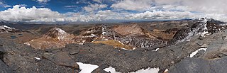
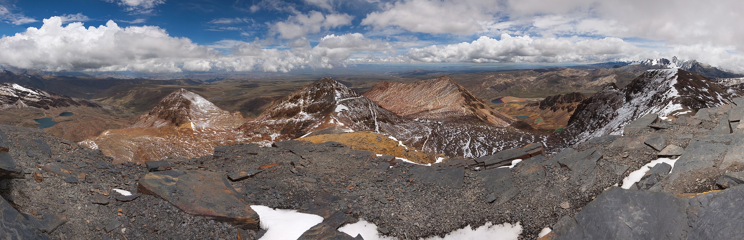
English: A panoramic view from the top of Chacaltaya (5421m). In the background you can see the cities of La Paz and El Alto (distance about 15km), as well as Lake Titicaca (distance about 50km). Panorama stitched from 16 portrait format images. The camera was rotated using a Nodal Ninja [1] nodal point adapter which was mounted on a tripod. All photos were taken with the same exposure settings in RAW format and developed with exactly the same settings in a RAW converter. For stitching PTGUI [2] was used.
Deutsch: Panorama vom Gipfel des Chacaltaya (5421 m). Im Hintergrund sieht man die Städte La Paz und El Alto (Entfernung etwa 15 km) sowie den Titicacasee (Entfernung etwa 50 km). Panorama zusammengesetzt aus 16 Hochformatbildern. Die Kamera wurde mit Hilfe eines Nodal Ninja [3] Nodalpunktadapters (der auf einem Stativ befestigt war) rotiert. Alle Fotos wurden mit denselben Belichtungseinstellungen im RAW-Format aufgezeichnet und mit denselben Einstellungen in einem RAW-Konverter entwickelt. Zum Zusammenfügen wurde PTGUI [4] verwendet.
Français : Vue panoramique prise du sommet du Chacaltaya (5421m). A l'arrière-plan, on peut discerner les villes de La Paz et El Alto (distance d'environ 15km), aussi bien que le lac Titicaca (distance d'environ 50km). Panorama ubtenu par la fusion de 16 images au format portrait. L'appareil photo a été mis en rotation avec un adaptateur Nodal Ninja [5] monté sur trépied. Toutes les photos ont été prises avec la même exposition en format RAW et développées avec les mêmes réglages. La fusion a été réalisée avec PTGUI [6]. |
| Date | |
| Source | Own work |
| Author | Christian Mehlführer, User:Chmehl |
| Camera location | | View this and other nearby images on: OpenStreetMap |
|---|
Licensing
[edit]
I, the copyright holder of this work, hereby publish it under the following license:
This file is licensed under the Creative Commons Attribution 3.0 Unported license.
- You are free:
- to share – to copy, distribute and transmit the work
- to remix – to adapt the work
- Under the following conditions:
- attribution – You must give appropriate credit, provide a link to the license, and indicate if changes were made. You may do so in any reasonable manner, but not in any way that suggests the licensor endorses you or your use.
File history
Click on a date/time to view the file as it appeared at that time.
| Date/Time | Thumbnail | Dimensions | User | Comment | |
|---|---|---|---|---|---|
| current | 20:57, 15 April 2009 | 10,000 × 3,227 (12.42 MB) | Chmehl (talk | contribs) | straightened panorama and corrected tilt | |
| 19:37, 15 April 2009 | 9,000 × 2,931 (10.5 MB) | Chmehl (talk | contribs) | straightened panorama and corrected tilt | ||
| 15:28, 13 April 2009 | 9,000 × 2,838 (10.98 MB) | Chmehl (talk | contribs) | {{Information |Description={{en|1=A panoramic view from the top of Chacaltaya (5421m). In the background you can see the cities of La Paz and El Alto (distance about 15km), as well as [[:en:Lake_Titicaca|L |
You cannot overwrite this file.
File usage on Commons
The following 27 pages use this file:
- User:Chmehl
- User talk:99of9/Promotions
- User talk:Chmehl
- Commons:Commons Monthly
- Commons:Featured picture candidates/File:Chacaltaya Pano MC.jpg
- Commons:Featured picture candidates/Log/February 2010
- Commons:Featured pictures/Places/Natural
- Commons:Featured pictures/Places/Panoramas
- Commons:Featured pictures/chronological/2010-A
- Commons:Picture of the Year/2010/Galleries/2010-A
- Commons:Picture of the Year/2010/Galleries/All
- Commons:Picture of the Year/2010/Galleries/Index/2
- Commons:Picture of the Year/2010/Galleries/Index/Panoramas
- Commons:Picture of the Year/2010/Galleries/Panoramas
- Commons:Picture of the Year/2010/Galleries/Panoramas/Large
- Commons:Picture of the Year/2010/Galleries/Panoramas/Small
- Commons:Picture of the Year/2010/Galleries/Table
- Commons:Picture of the Year/2010/Galleries/Table/02
- Commons:Picture of the Year/2010/R1/File:Chacaltaya Pano MC.jpg
- Commons:Picture of the Year/2010/Results/R1/ALL/Table
- Commons:Picture of the Year/2010/Results/R1/Panoramas
- Commons:Picture of the Year/2010/Results/R1/Panoramas/Table
- Commons:Quality images/Subject/Places/Natural structures/Panorama/Archive 2008 to 2015
- Commons:Quality images candidates/Archives April 2009
- Commons talk:Picture of the Year/2010/Galleries/Table
- Commons talk:Picture of the Year/2010/Results/R1/ALL/Table
- File:Chacaltaya banner.jpg
File usage on other wikis
The following other wikis use this file:
- Usage on es.wikipedia.org
- Usage on fa.wikipedia.org
- Usage on fr.wikipedia.org
- Usage on ha.wikipedia.org
- Usage on id.wikipedia.org
- Usage on krc.wikipedia.org
- Usage on pl.wikipedia.org
- Usage on tr.wikipedia.org
- Vikipedi:Seçkin resimler/Mekânlar/Panorama
- Chacaltaya
- Vikipedi:Seçkin resim adayları/Chacaltaya Pano MC.jpg
- Vikipedi:Seçkin resim adayları/Arşiv/Şubat 2010
- Vikipedi:Günün seçkin resmi/Ağustos 2011
- Şablon:GSR/2011-08-03
- Vikipedi:Seçkin resimler/Ana sayfaya çıkmış resimler/2011 listesi
- Vikipedi:Seçkin resimler/Ana sayfaya çıkmış resimler/2014 listesi
- Vikipedi:Günün seçkin resmi/Aralık 2014
- Şablon:GSR/2014-12-05
- Şablon:GSR/2017-05-11
- Vikipedi:Günün seçkin resmi/Mayıs 2017
- Usage on vi.wikipedia.org