File:Chechnya and Caucasus.png
Jump to navigation
Jump to search
No higher resolution available.
Chechnya_and_Caucasus.png (550 × 296 pixels, file size: 66 KB, MIME type: image/png)
Captions
Captions
Add a one-line explanation of what this file represents
Summary
[edit]
| Description |
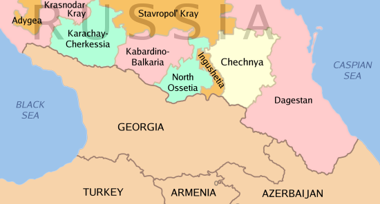
English: Map showing Chechnya's geographic relationship to the Caucasus region. |
| Date | |
| Source | Own work |
| Author | Kbh3rd |
| Other versions | Derivative works of this file: Caucasus Map Karta Kavkaza.jpg |

|
This locator map image could be re-created using vector graphics as an SVG file. This has several advantages; see Commons:Media for cleanup for more information. If an SVG form of this image is available, please upload it and afterwards replace this template with
{{vector version available|new image name}}.
It is recommended to name the SVG file “Chechnya and Caucasus.svg”—then the template Vector version available (or Vva) does not need the new image name parameter. |
Licensing
[edit]

|
Permission is granted to copy, distribute and/or modify this document under the terms of the GNU Free Documentation License, Version 1.2 or any later version published by the Free Software Foundation; with no Invariant Sections, no Front-Cover Texts, and no Back-Cover Texts. A copy of the license is included in the section entitled GNU Free Documentation License. |
| This file is licensed under the Creative Commons Attribution-Share Alike 3.0 Unported license. | ||
| ||
| This licensing tag was added to this file as part of the GFDL licensing update. |
File history
Click on a date/time to view the file as it appeared at that time.
| Date/Time | Thumbnail | Dimensions | User | Comment | |
|---|---|---|---|---|---|
| current | 16:32, 26 February 2022 | | 550 × 296 (66 KB) | AntiCompositeNumber (talk | contribs) | run pngfix per phab:T285875 |
| 05:15, 5 February 2005 |  | 550 × 296 (66 KB) | Kbh3rd (talk | contribs) | Map showing Chechnya's geographic relationship to the Caucasus region. {{GFDL}} |
You cannot overwrite this file.
File usage on Commons
The following 10 pages use this file:
File usage on other wikis
The following other wikis use this file:
- Usage on ar.wikipedia.org
- Usage on ast.wikipedia.org
- Usage on azb.wikipedia.org
- Usage on az.wikipedia.org
- Usage on be-tarask.wikipedia.org
- Usage on be.wikipedia.org
- Usage on bg.wikipedia.org
- Usage on bn.wikipedia.org
- Usage on ca.wikipedia.org
- Usage on cs.wikipedia.org
- Usage on cy.wikipedia.org
- Usage on da.wikipedia.org
- Usage on de.wikipedia.org
- Usage on diq.wikipedia.org
- Usage on el.wikipedia.org
- Usage on en.wikipedia.org
- Second Chechen War
- Avars (Caucasus)
- User:Kbh3rd/Images
- Beslan school siege
- 2005 raid on Nalchik
- Talk:Chechen Republic of Ichkeria
- Insurgency in the North Caucasus
- Wikipedia:Top 25 Report/April 14 to 20, 2013
- Wikipedia:Top 25 Report/April 21 to 27, 2013
- Cossack Lullaby
- Wikipedia:WikiProject Women in Red/Meetup/162
- User:PurpleHaze2022/The Provisional Council of the Chechen Republic
- User:Dainomite/Geopolitical interests
- Usage on en.wikibooks.org
- Usage on en.wiktionary.org
- Usage on eo.wikipedia.org
- Usage on es.wikipedia.org
- Usage on fa.wikipedia.org
- Usage on fi.wikipedia.org
View more global usage of this file.