File:China county-level divisions and administrative divisions (PRoC claim).png
Jump to navigation
Jump to search
Size of this preview: 759 × 600 pixels. Other resolutions: 304 × 240 pixels | 607 × 480 pixels | 972 × 768 pixels | 1,280 × 1,012 pixels | 2,560 × 2,023 pixels | 6,246 × 4,937 pixels.
Original file (6,246 × 4,937 pixels, file size: 1.54 MB, MIME type: image/png)
Captions
Captions
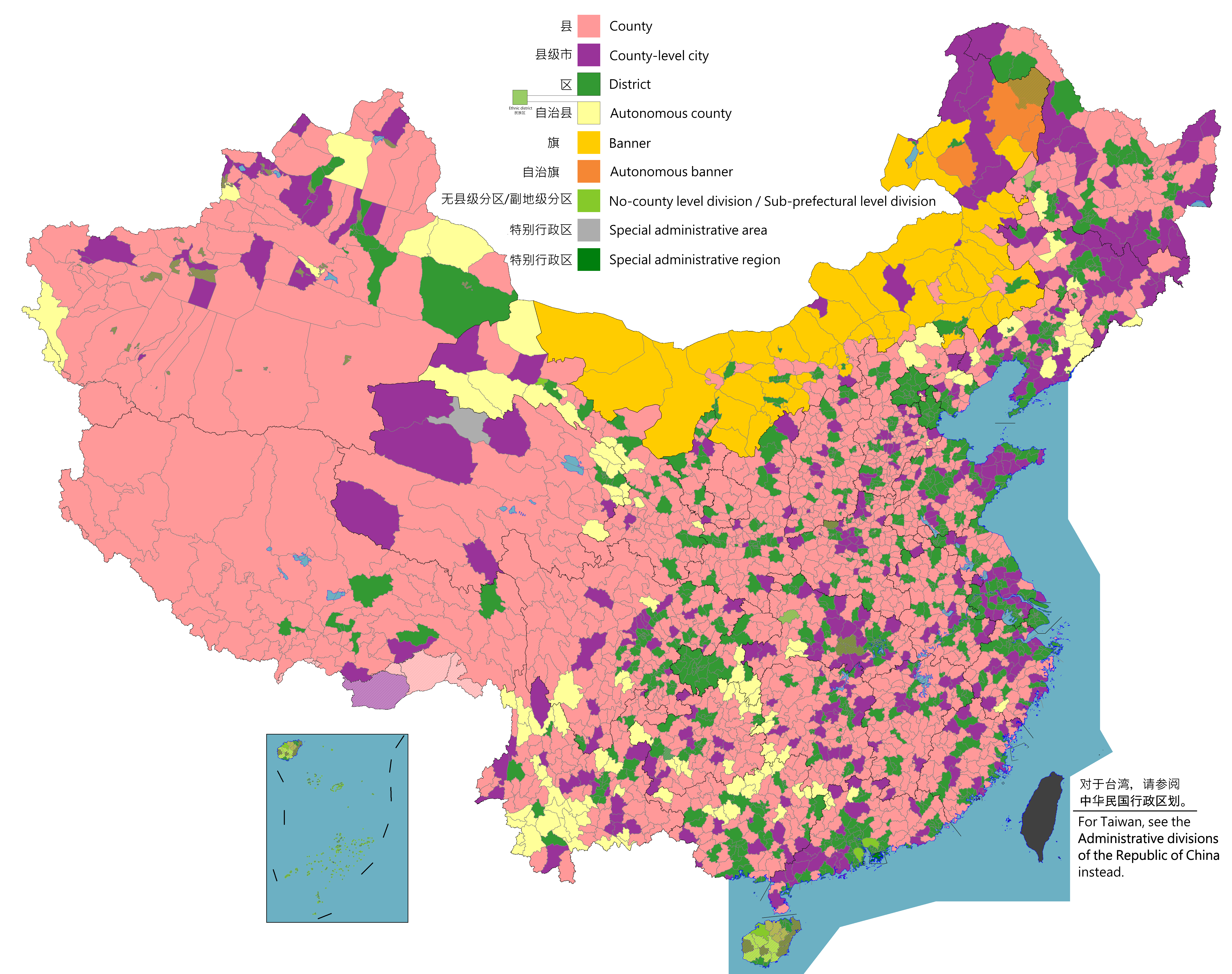
Map of China, shows that divided into counties, county-level cities, districts, etc.

This image should always reflect the most recent version. Feel free to update it when needed.
|

|
This file may be updated to reflect new information. If you wish to use a specific version of the file without it being overwritten, please upload the required version as a separate file. |
Summary
[edit].png&action=edit§ion=1)
| Description |
English: Map of China, shows counties, county-level cities, county-level districts, autonomous counties and banners, banners, etc.
日本語: 中国の地図は、郡、郡レベルの都市、郡レベルの地区、自治県とバナー、バナーなどを示しています。
Русский: Карта Китая, показывает уезды, города уездного уровня, уездные районы, автономные уезды и баннеры, баннеры и т. Д.
中文(简体):中国地图,显示县、县级市、县级区、自治县和旗、自治旗等。
中文(繁體):中國地圖,顯示縣、縣級市、縣級區、自治縣和旗、自治旗等。 |
||
| Date |
|
||
| Source |
Legend: English:
County
County-level city
County-level district
Autonomous county
Banner
Autonomous banner
No county-level division / Sub-prefectural level division
Special district
Special administrative region 中文(简体): 县
县级市
县级区
自治县
旗
自治旗
无县级/副地级
特区
特别行政区 |
||
| Author |
|
||
| Permission (Reusing this file) |
Map of China, administrative divisions: I, the copyright holder of this work, hereby publish it under the following license:
|
Licensing
[edit].png&action=edit§ion=2)
I, the copyright holder of this work, hereby publish it under the following license:
This file is licensed under the Creative Commons Attribution-Share Alike 4.0 International license.
- You are free:
- to share – to copy, distribute and transmit the work
- to remix – to adapt the work
- Under the following conditions:
- attribution – You must give appropriate credit, provide a link to the license, and indicate if changes were made. You may do so in any reasonable manner, but not in any way that suggests the licensor endorses you or your use.
- share alike – If you remix, transform, or build upon the material, you must distribute your contributions under the same or compatible license as the original.

|
This map image could be re-created using vector graphics as an SVG file. This has several advantages; see Commons:Media for cleanup for more information. If an SVG form of this image is available, please upload it and afterwards replace this template with
{{vector version available|new image name}}.
It is recommended to name the SVG file “China county-level divisions and administrative divisions (PRoC claim).svg”—then the template Vector version available (or Vva) does not need the new image name parameter. |
| Annotations | This image is annotated: View the annotations at Commons |
.png)
Any autoconfirmed user can overwrite this file from the same source. Please ensure that overwrites comply with the guideline.
File history
Click on a date/time to view the file as it appeared at that time.
.png&dir=prev)
.png&offset=20220329005936)
.png&offset=&limit=20)
.png&offset=&limit=50)
.png&offset=&limit=100)
.png&offset=&limit=250)
.png&offset=&limit=500)
| Date/Time | Thumbnail | Dimensions | User | Comment | |
|---|---|---|---|---|---|
| current | 08:59, 1 August 2023 | | 6,246 × 4,937 (1.54 MB) | Maanshen (talk | contribs) | Add Baiyang, update and fix Nanchang borders |
| 08:32, 1 August 2023 |  | 6,246 × 4,937 (1.54 MB) | Maanshen (talk | contribs) | Update: Tsona County -> Tsona City, Mainling County -> Mainling City | |
| 12:30, 31 July 2023 |  | 6,246 × 4,937 (1.41 MB) | Baomi (talk | contribs) | ||
| 16:35, 16 July 2023 |  | 6,246 × 4,937 (1.59 MB) | Josemite (talk | contribs) | That old nine-dashed line is badly drawn | |
| 09:52, 17 February 2023 |  | 6,246 × 4,937 (1.55 MB) | 梦夕琳 (talk | contribs) | 修改香港区界 | |
| 23:06, 2 August 2022 |  | 6,246 × 4,937 (1.55 MB) | Maanshen (talk | contribs) | Update disputed/claimed borders, white with stroke is not claimed and filled in color is claimed | |
| 00:08, 20 April 2022 |  | 6,246 × 4,937 (1.54 MB) | Maanshen (talk | contribs) | Fix borders between Ili's Kuytun, Huyanghe, and Karamay | |
| 23:41, 19 April 2022 |  | 6,246 × 4,937 (1.54 MB) | Maanshen (talk | contribs) | Fix colors again in Honghe counties | |
| 01:45, 31 March 2022 |  | 6,246 × 4,937 (1.54 MB) | Maanshen (talk | contribs) | Fix some colors | |
| 00:59, 29 March 2022 |  | 6,246 × 4,937 (1.54 MB) | Maanshen (talk | contribs) | Fix colors in Shanxi with Fenyang and Xiaoyi |
You cannot overwrite this file.
File usage on Commons
The following 10 pages use this file:
- File:China Counties.png
- File:China County-level.png (file redirect)
- File:China County-level cities.png
- File:China County-level divisions (PRC claim).png (file redirect)
- File:China County-level divisions (PRC claim) sl.png
- File:China Districts.png
- File:Cities in China.png
- Template:Other versions/China County-level divisions
- Template:Other versions/China city-level source versions
- Template:Other versions/China is divided into county-level divisions
.png&redirect=no)
_sl.png)
File usage on other wikis
The following other wikis use this file:
- Usage on ar.wikipedia.org
- Usage on ast.wikipedia.org
- Usage on az.wikipedia.org
- Usage on ca.wikipedia.org
- Usage on ce.wikipedia.org
- Usage on cs.wikipedia.org
- Usage on de.wikipedia.org
- Usage on en.wikipedia.org
- Usage on es.wikipedia.org
- Usage on fa.wikipedia.org
- Usage on fi.wikipedia.org
- Usage on fr.wikipedia.org
- Usage on id.wikipedia.org
- Usage on ja.wikipedia.org
- Usage on mk.wikipedia.org
- Usage on nl.wikipedia.org
- Usage on no.wikipedia.org
- Usage on pnb.wikipedia.org
- Usage on ru.wikipedia.org
- Usage on sv.wikipedia.org
- Usage on th.wikipedia.org
- Usage on tr.wikipedia.org
- Usage on uk.wikipedia.org
- Usage on ur.wikipedia.org
- Usage on vi.wikipedia.org
- Usage on www.wikidata.org
- Usage on zh.wikipedia.org
View more global usage of this file.
.png)
.png&oldid=822587588)