File:China in 1949.svg
Jump to navigation
Jump to search

Size of this PNG preview of this SVG file: 753 × 599 pixels. Other resolutions: 302 × 240 pixels | 603 × 480 pixels | 965 × 768 pixels | 1,280 × 1,019 pixels | 2,560 × 2,038 pixels | 1,181 × 940 pixels.
Original file (SVG file, nominally 1,181 × 940 pixels, file size: 2.12 MB)
Captions
Captions
Add a one-line explanation of what this file represents
Summary
[edit]| Description |
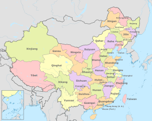
English: Map of China in 1949. (Note: Chinese point of view) |
| Date | |
| Source |
Own work based on: China (+claims, +Hainan), administrative divisions - Blank - colored.svg |
| Author | Milenioscuro |
| Other versions |
|


,_administrative_divisions_-_Blank_-_colored.svg)
Licensing
[edit]
I, the copyright holder of this work, hereby publish it under the following license:
This file is licensed under the Creative Commons Attribution-Share Alike 4.0 International license.
- You are free:
- to share – to copy, distribute and transmit the work
- to remix – to adapt the work
- Under the following conditions:
- attribution – You must give appropriate credit, provide a link to the license, and indicate if changes were made. You may do so in any reasonable manner, but not in any way that suggests the licensor endorses you or your use.
- share alike – If you remix, transform, or build upon the material, you must distribute your contributions under the same or compatible license as the original.
File history
Click on a date/time to view the file as it appeared at that time.
| Date/Time | Thumbnail | Dimensions | User | Comment | |
|---|---|---|---|---|---|
| current | 18:31, 31 January 2020 | | 1,181 × 940 (2.12 MB) | Milenioscuro (talk | contribs) | User created page with UploadWizard |
You cannot overwrite this file.
File usage on Commons
The following 13 pages use this file:
- File:China, administrative divisions - es - colored.svg
- File:China in 1820.svg
- File:China in 1911.svg
- File:China in 1936.svg
- File:China in 1946.svg
- File:China in 1949.svg
- File:China in 1950.svg
- File:China in 1952.svg
- File:China in 1954.svg
- File:China in 1955.svg
- File:China in 1966.svg
- File:China in 1968.svg
- File:China in 1979.svg
File usage on other wikis
The following other wikis use this file:
- Usage on de.wikipedia.org
- Usage on en.wikipedia.org
- Usage on zh.wikipedia.org
Metadata
Categories:
- Maps of former provinces of China
- Territorial evolution of China
- SVG labeled maps of administrative divisions of China (location map scheme)
- SVG maps of the history of China
- English-language SVG maps showing history
- Chahar
- Hejiang
- Liaobei
- Rehe
- Songjiang Province
- Suiyuan
- Xingan
- Xikang
- SVG maps of the People's Republic of China
- Maps showing 1949
- SVG maps of the Republic of China (1912–1949)