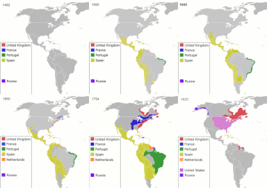
File:Colonisation2.gif

Original file (1,849 × 810 pixels, file size: 2.08 MB, MIME type: image/gif, looped, 12 frames, 48 s)
Captions
Captions
Summary
[edit]| DescriptionColonisation2.gif |
English: Map indicating the territories colonized by the European powers, United States and Japan.
Русский: Карта с указанием территорий, колонизированных Европейскими державами, Соединёнными штатами и Японией.
|
|||||||||||||||||||
| Date | 23 June 2008 (original upload date) | |||||||||||||||||||
| Source | Transferred from en.wikipedia to Commons. | |||||||||||||||||||
| Author | ArdadN at English Wikipedia | |||||||||||||||||||
| Other versions |
Derivative works of this file: |
|||||||||||||||||||
Licensing
[edit]| Public domainPublic domainfalsefalse |
| I, the copyright holder of this work, release this work into the public domain. This applies worldwide. In some countries this may not be legally possible; if so: I grant anyone the right to use this work for any purpose, without any conditions, unless such conditions are required by law. |
File history
Click on a date/time to view the file as it appeared at that time.
| Date/Time | Thumbnail | Dimensions | User | Comment | |
|---|---|---|---|---|---|
| current | 15:40, 5 October 2020 |  | 1,849 × 810 (2.08 MB) | Ориенталист (talk | contribs) | Colour correction |
| 14:19, 10 May 2020 |  | 800 × 379 (606 KB) | Ориенталист (talk | contribs) | Cosmetic changes | |
| 09:39, 5 April 2020 |  | 800 × 351 (561 KB) | Ориенталист (talk | contribs) | Last time i forgot 1914. Аdded it, little changes | |
| 09:49, 4 April 2020 |  | 800 × 351 (495 KB) | Ориенталист (talk | contribs) | Changed maps for 1492, 1550, 1660, 1754. Added a map for 1600. | |
| 11:29, 9 January 2019 |  | 1,425 × 625 (101 KB) | ArdadN (talk | contribs) | fixed Ireland 1754, Morocco 1914, Russian-German border 1885 and 1914, German-French border 1885 and 1914, German-Danish border 1885, Austria and Sudetenland 1938 | |
| 08:54, 23 July 2018 |  | 1,425 × 625 (101 KB) | SuperSucker (talk | contribs) | fix - believe in 1938 ethiopia was under european occupation as well.. italy had taken the capital Addis-Abeba in 1936 indeed | |
| 20:27, 4 June 2012 |  | 1,425 × 625 (101 KB) | Mnlk (talk | contribs) | i corrected the error that falsly depicted ethiopia as colony of fascist italy | |
| 19:49, 19 February 2011 |  | 1,425 × 625 (246 KB) | NordNordWest (talk | contribs) | corrected according to http://de.wikipedia.org/w/index.php?title=Benutzer_Diskussion%3ANordNordWest&action=historysubmit&diff=85468547&oldid=85447379 | |
| 19:40, 18 February 2011 |  | 1,425 × 625 (236 KB) | NordNordWest (talk | contribs) | corrected according to http://de.wikipedia.org/w/index.php?title=Benutzer_Diskussion%3ANordNordWest&action=historysubmit&diff=85447379&oldid=85351900 | |
| 19:42, 16 September 2010 |  | 1,425 × 625 (257 KB) | NordNordWest (talk | contribs) | further corrections |
You cannot overwrite this file.
File usage on Commons
The following 16 pages use this file:
- User:Chumwa/OgreBot/Potential transport maps/2018 July 21-31
- User:Chumwa/OgreBot/Potential transport maps/2019 January 1-10
- User:Chumwa/OgreBot/Transport Maps/2018 July 21-31
- User:Chumwa/OgreBot/Transport Maps/2019 January 1-10
- User:Chumwa/OgreBot/Transport Maps/2020 April 1-10
- User:Chumwa/OgreBot/Transport Maps/2020 May 1-10
- User:Chumwa/OgreBot/Transport Maps/2020 October 1-10
- User:Chumwa/OgreBot/Travel and communication maps/2018 July 21-31
- User:Chumwa/OgreBot/Travel and communication maps/2019 January 1-10
- User:Magog the Ogre/Multilingual legend/2020 April 1-10
- User:Magog the Ogre/Multilingual legend/2020 May 1-10
- User:Magog the Ogre/Multilingual legend/2020 October 1-10
- File:Colonisation2-de.gif
- File:Colonisation2.svg
- File:Colonisation2 (Americas cropped).gif
- File talk:Spanish Empire.png
File usage on other wikis
The following other wikis use this file:
- Usage on ar.wikipedia.org
- Usage on av.wikipedia.org
- Usage on azb.wikipedia.org
- Usage on az.wikipedia.org
- Usage on ba.wikipedia.org
- Usage on be-tarask.wikipedia.org
- Usage on be.wikipedia.org
- Usage on bg.wikipedia.org
- Usage on bn.wikipedia.org
- Usage on bn.wikibooks.org
- Usage on ce.wikipedia.org
- Usage on crh.wikipedia.org
- Usage on cs.wikipedia.org
- Usage on da.wikipedia.org
- Usage on de.wikipedia.org
- Usage on diq.wikipedia.org
- Usage on en.wikipedia.org
- History of Europe
- Early modern period
- Maritime history
- Colonial empire
- History of colonialism
- User:Palaeovia
- Portal:Maps/Maps/World
- Portal:Maps/Maps/World/18
- History of globalization
- User talk:AtomAtom
- User:Kazkaskazkasako/Books/History
- Outline of globalization
- Decoloniality
- Wikipedia:Graphics Lab/Map workshop/Archive/Apr 2014
- User:Bongan
View more global usage of this file.
Metadata
This file contains additional information such as Exif metadata which may have been added by the digital camera, scanner, or software program used to create or digitize it. If the file has been modified from its original state, some details such as the timestamp may not fully reflect those of the original file. The timestamp is only as accurate as the clock in the camera, and it may be completely wrong.
| GIF file comment |
|---|
