File:Constantine department 1934-1955 map-fr.svg
Jump to navigation
Jump to search

Size of this PNG preview of this SVG file: 604 × 600 pixels. Other resolutions: 242 × 240 pixels | 483 × 480 pixels | 773 × 768 pixels | 1,031 × 1,024 pixels | 2,062 × 2,048 pixels | 1,287 × 1,278 pixels.
Original file (SVG file, nominally 1,287 × 1,278 pixels, file size: 1.79 MB)
Captions
Captions
Add a one-line explanation of what this file represents
Summary
[edit]
| Description |
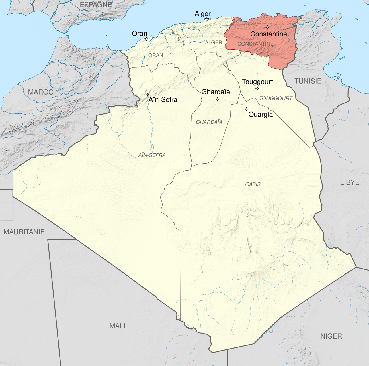
English: Administrative map of French Algeria from 1934 to 1955, showing the Constantine department in pink.
Français : Carte administrative de l'Algérie française, de 1934 à 1955, montrant le Département de Constantine en rose.
|
| Date | (UTC) |
| Source |
This file was derived from: French Algeria 1934-1955 administrative map-fr.svg:  |
| Author |
|
| Other versions | |
| Attribution (required by the license) | © Sémhur / Wikimedia Commons / |
| SVG development |
| Camera location | | View this and other nearby images on: OpenStreetMap |
|---|
Licensing
[edit]
I, the copyright holder of this work, hereby publish it under the following licenses:
| Copyleft: This work of art is free; you can redistribute it and/or modify it according to terms of the Free Art License. You will find a specimen of this license on the Copyleft Attitude site as well as on other sites. |
This file is licensed under the Creative Commons Attribution-Share Alike 4.0 International, 3.0 Unported, 2.5 Generic, 2.0 Generic and 1.0 Generic license.
- You are free:
- to share – to copy, distribute and transmit the work
- to remix – to adapt the work
- Under the following conditions:
- attribution – You must give appropriate credit, provide a link to the license, and indicate if changes were made. You may do so in any reasonable manner, but not in any way that suggests the licensor endorses you or your use.
- share alike – If you remix, transform, or build upon the material, you must distribute your contributions under the same or compatible license as the original.
You may select the license of your choice.
Original upload log
[edit]
This image is a derivative work of the following images:
- File:French_Algeria_1934-1955_administrative_map-fr.svg licensed with Cc-by-sa-3.0,2.5,2.0,1.0, FAL
- 2012-10-03T07:33:11Z Sémhur 1287x1278 (1817570 Bytes) 2 - With scale
- 2012-10-02T07:17:53Z Sémhur 1287x1278 (1817568 Bytes) == {{int:filedesc}} == {{Information |Description={{Multilingual description |en= Administrative map of [[:en:French Algeria|French Algeria]] from 1905 to 1955. Three departments in the north: Alger, Constantine, Oran. Four t
Uploaded with derivativeFX
File history
Click on a date/time to view the file as it appeared at that time.
| Date/Time | Thumbnail | Dimensions | User | Comment | |
|---|---|---|---|---|---|
| current | 07:14, 23 May 2014 | | 1,287 × 1,278 (1.79 MB) | Sémhur (talk | contribs) | Valid SVG |
| 08:49, 5 October 2012 |  | 1,287 × 1,278 (1.79 MB) | Sémhur (talk | contribs) | == {{int:filedesc}} == {{Information |Description={{Multilingual description |en= Administrative map of French Algeria from 1934 to 1955, showing the Constantine department in pink.<br/> * Scale... |
You cannot overwrite this file.
File usage on Commons
There are no pages that use this file.
File usage on other wikis
The following other wikis use this file:
- Usage on ar.wikipedia.org
- Usage on de.wikipedia.org
- Usage on en.wikipedia.org
- Usage on fr.wikipedia.org
- Usage on sv.wikipedia.org
- Usage on zh.wikipedia.org