File:Costco footprint map USA 2021-01.png
Jump to navigation
Jump to search
Size of this preview: 800 × 417 pixels. Other resolutions: 320 × 167 pixels | 640 × 334 pixels | 1,024 × 534 pixels | 1,280 × 667 pixels | 2,936 × 1,530 pixels.
Original file (2,936 × 1,530 pixels, file size: 1.09 MB, MIME type: image/png)
Captions
Captions
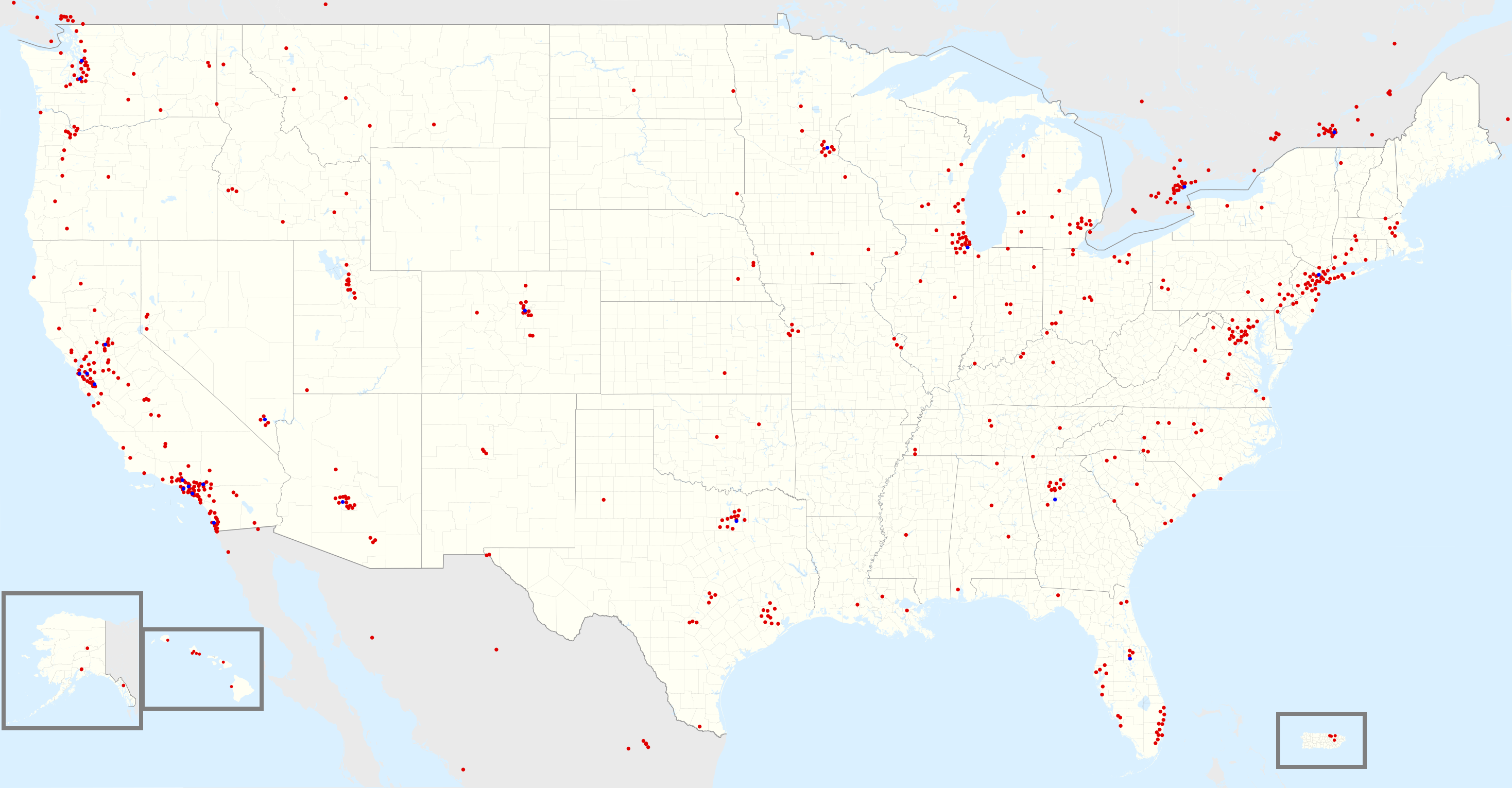
Costco locations in USA (including parts of Canada & Mexico) (Business centers in blue)
Related Maps
[edit]
 |
 |
Data
[edit]
North America store count by state/provience (as of January 2021)
| Country | State/Province | Count |
|---|---|---|
| USA | California | 131 |
| Canada | Ontario | 36 |
| USA | Texas | 33 |
| USA | Washington | 32 |
| USA | Florida | 28 |
| USA | Illinois | 22 |
| Canada | Quebec | 22 |
| USA | New Jersey | 21 |
| USA | New York | 19 |
| USA | Arizona | 18 |
| Canada | Alberta | 18 |
| USA | Virginia | 17 |
| USA | Michigan | 16 |
| USA | Colorado | 14 |
| Canada | British Columbia | 14 |
| USA | Georgia | 13 |
| USA | Oregon | 13 |
| USA | Minnesota | 12 |
| USA | Ohio | 12 |
| USA | Utah | 12 |
| USA | Maryland | 11 |
| USA | Pennsylvania | 11 |
| USA | North Carolina | 9 |
| USA | Wisconsin | 9 |
| USA | Nevada | 8 |
| USA | Connecticut | 7 |
| USA | Hawaii | 7 |
| USA | Idaho | 7 |
| USA | Indiana | 7 |
| USA | Massachusetts | 6 |
| USA | Missouri | 6 |
| USA | South Carolina | 6 |
| Mexico | México | 6 |
| USA | Montana | 5 |
| USA | Tennessee | 5 |
| Mexico | Ciudad de México | 5 |
| USA | Alabama | 4 |
| USA | Alaska | 4 |
| USA | Kentucky | 4 |
| USA | Puerto Rico | 4 |
| Canada | New Brunswick | 4 |
| Mexico | Baja California | 4 |
| Mexico | Nuevo León | 4 |
| USA | Iowa | 3 |
| USA | Kansas | 3 |
| USA | Louisiana | 3 |
| USA | Nebraska | 3 |
| USA | New Mexico | 3 |
| Canada | Manitoba | 3 |
| Canada | Saskatchewan | 3 |
| Mexico | Jalisco | 3 |
| USA | North Dakota | 2 |
| USA | Oklahoma | 2 |
| Mexico | Chihuahua | 2 |
| Mexico | Guanajuato | 2 |
| Mexico | Veracruz | 2 |
| USA | Delaware | 1 |
| USA | District of Columbia | 1 |
| USA | Mississippi | 1 |
| USA | New Hampshire | 1 |
| USA | South Dakota | 1 |
| USA | Vermont | 1 |
| Canada | Newfoundland and Labrador | 1 |
| Canada | Nova Scotia | 1 |
| Mexico | Aguascalientes | 1 |
| Mexico | Baja California Sur | 1 |
| Mexico | Coahuila | 1 |
| Mexico | Morelos | 1 |
| Mexico | Puebla | 1 |
| Mexico | Querétaro | 1 |
| Mexico | Quintana Roo | 1 |
| Mexico | San Luis Potosi | 1 |
| Mexico | Sinaloa | 1 |
| Mexico | Sonora | 1 |
| Mexico | Yucatán | 1 |
Summary
[edit]
| Point Maps
══▻ FAQ ◅══ ══▻ Create your own ◅══ |
Licensing
[edit]
| This work is ineligible for copyright and therefore in the public domain because it consists entirely of information that is common property and contains no original authorship. |
File history
Click on a date/time to view the file as it appeared at that time.
| Date/Time | Thumbnail | Dimensions | User | Comment | |
|---|---|---|---|---|---|
| current | 23:51, 4 January 2021 | | 2,936 × 1,530 (1.09 MB) | BoringJim (talk | contribs) | resize & recolour of dots |
| 22:14, 4 January 2021 |  | 2,936 × 1,530 (698 KB) | BoringJim (talk | contribs) | Uploaded own work with UploadWizard |
You cannot overwrite this file.
File usage on Commons
There are no pages that use this file.
File usage on other wikis
The following other wikis use this file:
- Usage on en.wikipedia.org
- Usage on id.wikipedia.org
- Usage on ja.wikipedia.org
- Usage on vi.wikipedia.org
- Usage on zh.wikipedia.org