File:Ctcolony.png
Jump to navigation
Jump to search

Size of this preview: 800 × 560 pixels. Other resolutions: 320 × 224 pixels | 640 × 448 pixels | 1,024 × 717 pixels | 1,428 × 1,000 pixels.
Original file (1,428 × 1,000 pixels, file size: 817 KB, MIME type: image/png)
Captions
Captions
Add a one-line explanation of what this file represents
Summary
[edit]
| Description |
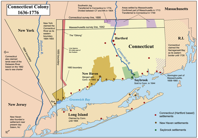
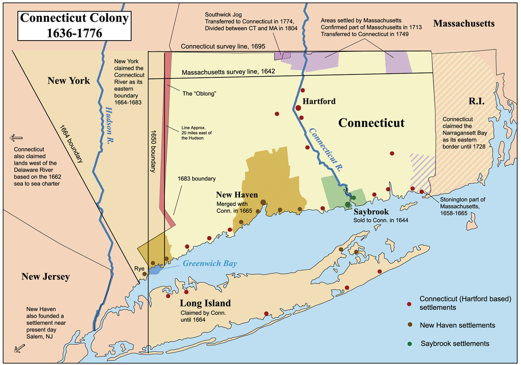
This is a map showing the Connecticut, New Haven, and Saybrook colonies from 1636-1776. It includes the territorial disputes between Connecticut and its neighbors during that time period. It does not show Connecticut's western land claims and dispute with Pennsylvania. Based primarily on descriptions from The Boundary Disputes of Connecticut by Clarence Winthrop Bowen. James R. Osgood and Company, Boston, 1882. |
| Date | 12 October 2006 (original upload date) |
| Source | No machine-readable source provided. Own work assumed (based on copyright claims). |
| Author | No machine-readable author provided. Kmusser assumed (based on copyright claims). |
Licensing
[edit]
I, the copyright holder of this work, hereby publish it under the following license:
This file is licensed under the Creative Commons Attribution-Share Alike 2.5 Generic license.
- You are free:
- to share – to copy, distribute and transmit the work
- to remix – to adapt the work
- Under the following conditions:
- attribution – You must give appropriate credit, provide a link to the license, and indicate if changes were made. You may do so in any reasonable manner, but not in any way that suggests the licensor endorses you or your use.
- share alike – If you remix, transform, or build upon the material, you must distribute your contributions under the same or compatible license as the original.
Format
[edit]

|
This historical map image could be re-created using vector graphics as an SVG file. This has several advantages; see Commons:Media for cleanup for more information. If an SVG form of this image is available, please upload it and afterwards replace this template with
{{vector version available|new image name}}.
It is recommended to name the SVG file “Ctcolony.svg”—then the template Vector version available (or Vva) does not need the new image name parameter. |
File history
Click on a date/time to view the file as it appeared at that time.
| Date/Time | Thumbnail | Dimensions | User | Comment | |
|---|---|---|---|---|---|
| current | 04:06, 2 June 2014 | | 1,428 × 1,000 (817 KB) | JeffyP (talk | contribs) | I'm here to make the world a little bit smaller ☺ |
| 19:19, 10 January 2008 |  | 1,428 × 1,000 (909 KB) | Kmusser (talk | contribs) | Major revision to include disputes with Massachusetts and Rhode Island. | |
| 16:54, 12 October 2006 |  | 800 × 680 (190 KB) | Kmusser (talk | contribs) | == Summary == This is a map showing the Connecticut, New Haven, and Saybrook colonies from 1636-1776. It includes the territorial dispute between Connecticut |
You cannot overwrite this file.
File usage on Commons
The following 7 pages use this file:
File usage on other wikis
The following other wikis use this file:
- Usage on bg.wikipedia.org
- Usage on bn.wikipedia.org
- Usage on ce.wikipedia.org
- Usage on da.wikipedia.org
- Usage on de.wikipedia.org
- Usage on en.wikipedia.org
- Connecticut
- Fishers Island, New York
- New Haven Colony
- History of Connecticut
- Connecticut Colony
- John Haynes (governor)
- Saybrook Colony
- User:Kmusser/Images
- List of colonial governors of Connecticut
- History of Long Island
- New England Colonies
- Portal:Connecticut
- Thomas Powell (American landowner)
- User:Falcaorib/Canada, United States and Mexico
- Usage on en.wikiversity.org
- Usage on es.wikipedia.org
- Usage on fr.wikipedia.org
- Usage on fy.wikipedia.org
- Usage on he.wikipedia.org
- Usage on hu.wikipedia.org
- Usage on hy.wikipedia.org
- Usage on id.wikipedia.org
- Usage on it.wikipedia.org
View more global usage of this file.