File:CuartaParticiónDePolonia1939.svg
Jump to navigation
Jump to search

Size of this PNG preview of this SVG file: 622 × 510 pixels. Other resolutions: 293 × 240 pixels | 586 × 480 pixels | 937 × 768 pixels | 1,249 × 1,024 pixels | 2,498 × 2,048 pixels.
Original file (SVG file, nominally 622 × 510 pixels, file size: 45 KB)
Captions
Captions
Add a one-line explanation of what this file represents
| Description |
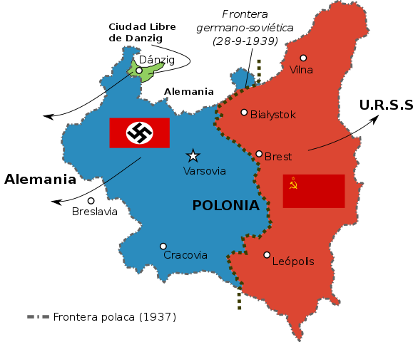
Español: Frontera germano-soviética del 29 de septiembre de 1939, con la repartición de territorios polacos entre los dos países invasores.
English: Line of demarcation between German and Soviet military forces after their joint invasion of Poland in September 1939
Polski: Linia spotkania wojsk radzieckich i niemieckich podczas inwazji na Polskę we wrześniu 1939 |
||
| Date | (UTC) | ||
| Source | |||
| Author |
|
||
| SVG development |
|
_corr.png)
.svg)
.svg)
Licensing
[edit]
This file is licensed under the Creative Commons Attribution-Share Alike 3.0 Unported license.
- You are free:
- to share – to copy, distribute and transmit the work
- to remix – to adapt the work
- Under the following conditions:
- attribution – You must give appropriate credit, provide a link to the license, and indicate if changes were made. You may do so in any reasonable manner, but not in any way that suggests the licensor endorses you or your use.
- share alike – If you remix, transform, or build upon the material, you must distribute your contributions under the same or compatible license as the original.
File history
Click on a date/time to view the file as it appeared at that time.
| Date/Time | Thumbnail | Dimensions | User | Comment | |
|---|---|---|---|---|---|
| current | 16:19, 12 September 2016 | | 622 × 510 (45 KB) | Rowanwindwhistler (talk | contribs) | Lvov->Leópolis Breslau->Breslavia Lighter colours Clearer border |
| 22:32, 27 August 2010 |  | 622 × 510 (40 KB) | Rowanwindwhistler (talk | contribs) | {{Information |Description={{es|1=Frontera germano-soviética del 29 de septiembre de 1939, con la repartición de territorios polacos entre los dos países invasores.}} {{en|1=Line of demarcation between German and Soviet military forces after their join |
You cannot overwrite this file.
File usage on Commons
The following 3 pages use this file:
File usage on other wikis
The following other wikis use this file:
- Usage on bs.wikipedia.org
- Usage on es.wikipedia.org
- Usage on es.wikibooks.org
- Usage on hr.wikipedia.org
- Usage on pt.wikipedia.org
- Usage on sh.wikipedia.org