File:Départements et régions de France vide.svg
From Wikimedia Commons, the free media repository
Jump to navigation
Jump to search

Size of this PNG preview of this SVG file: 530 × 550 pixels. Other resolutions: 231 × 240 pixels | 463 × 480 pixels | 740 × 768 pixels | 987 × 1,024 pixels | 1,974 × 2,048 pixels.
Original file (SVG file, nominally 530 × 550 pixels, file size: 210 KB)
File information
Structured data
Captions
Captions
Add a one-line explanation of what this file represents
Summary
[edit]| DescriptionDépartements et régions de France vide.svg |
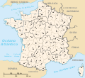
English: Frontiers of departements and regions of France.
Français : Limites des départements et régions de France, sans aucune légende. |
||
| Date | (UTC) | ||
| Source |
|
||
| Author |
|
||
| Other versions |
[edit]
|
Licensing
[edit]I, the copyright holder of this work, hereby publish it under the following license:
| Public domainPublic domainfalsefalse |
| I, the copyright holder of this work, release this work into the public domain. This applies worldwide. In some countries this may not be legally possible; if so: I grant anyone the right to use this work for any purpose, without any conditions, unless such conditions are required by law. |
Original upload log
[edit]This image is a derivative work of the following images:
- File:Départements et régions de France.svg licensed with PD-self
- 2009-05-16T02:55:39Z Archimatth 588x550 (477536 Bytes) Une seule préfecture varoise
- 2008-06-20T07:26:42Z Bayo 588x550 (478078 Bytes) patch region/departement id with ISO 3166-2:FR
- 2008-06-17T09:02:28Z Bayo 588x550 (485696 Bytes) {{Information |Description= |Source= |Date= |Author= |Permission= |other_versions= }}
- 2008-05-10T16:56:23Z Bayo 588x550 (470290 Bytes) region name bigger, patch typo of some names
- 2006-05-22T20:34:29Z Bayo 588x550 (470278 Bytes) patch : typo
- 2006-04-17T15:11:41Z Bayo 588x550 (470275 Bytes) ajout de l'échelle
- 2006-04-17T14:45:23Z Bayo 588x550 (465538 Bytes) *'''description''' : Départements et régions et de France avec leurs préfectures. *'''auteur''' : [[User:bayo|bayo]] [[Category:Maps of departements of France]] [[Category:Maps of régions of France]] == Licensing == {{P
Uploaded with derivativeFX
File history
Click on a date/time to view the file as it appeared at that time.
| Date/Time | Thumbnail | Dimensions | User | Comment | |
|---|---|---|---|---|---|
| current | 15:05, 15 May 2024 |  | 530 × 550 (210 KB) | Jack ma (talk | contribs) | Updated regions limits, improved visibility |
| 15:34, 27 April 2011 |  | 530 × 550 (215 KB) | Darkdadaah (talk | contribs) | {{Information |Description={{en|Frontiers of departements and regions of France.}} {{fr|Limites des départements et régions de France, sans aucune légende.}} |Source=*File:Départements_et_régions_de_France.svg |Date=2011-04-27 15:32 (UTC) |Auth |
You cannot overwrite this file.
File usage on Commons
The following 15 pages use this file:
- File:Departamantoù Frañs.svg
- File:Departamentos e rexións de Francia.svg
- File:Dipartimenti francesi.svg
- File:Départements de France.svg
- File:Départements de France English.svg
- File:Départements de France Korean.svg
- File:Départements de France Macedonian.svg
- File:Départements de France VI.svg
- File:Départements de France hr.svg
- File:Départements et régions de France.svg
- File:Départements et régions de France eo.svg
- File:Départements et régions de France es.svg
- File:Départements et régions de France vide.svg
- File:Regiones metropolitanas de Francia.svg
- Template:Other versions/Départements et régions de France
File usage on other wikis
The following other wikis use this file:
- Usage on fr.wiktionary.org
Metadata
This file contains additional information such as Exif metadata which may have been added by the digital camera, scanner, or software program used to create or digitize it. If the file has been modified from its original state, some details such as the timestamp may not fully reflect those of the original file. The timestamp is only as accurate as the clock in the camera, and it may be completely wrong.
| Width | 530 |
|---|---|
| Height | 550 |
![(français) Départements (numérotés) et régions de France avant 01/01/2016 (nommées, non colorisés) [source of all the following derivatives]](https://upload.wikimedia.org/wikipedia/commons/thumb/1/1e/D%C3%A9partements_et_r%C3%A9gions_de_France.svg/120px-D%C3%A9partements_et_r%C3%A9gions_de_France.svg.png)


![(français) Départements (numérotés) et régions de France avant 01/01/2016 (non nommées, non colorisées) [rendu amélioré] (version utilisée pour rendre la carte clicable par département)](https://upload.wikimedia.org/wikipedia/commons/thumb/7/7e/D%C3%A9partements_et_r%C3%A9gions_de_France_-_Noname-2016.svg/120px-D%C3%A9partements_et_r%C3%A9gions_de_France_-_Noname-2016.svg.png)


![(français) Départements (numérotés) et régions de France avant 01/01/2016 (nommées et colorisées) [regions named/colored]](https://upload.wikimedia.org/wikipedia/commons/thumb/e/e4/D%C3%A9partements%2Br%C3%A9gions_%28France%29.svg/120px-D%C3%A9partements%2Br%C3%A9gions_%28France%29.svg.png)
![(français) Départements (numérotés) et régions de France avant 01/01/2016 (nommées et colorisées) [15% magnified, rapid JPEG format 5x faster]](https://upload.wikimedia.org/wikipedia/commons/thumb/8/81/France_departements_regions_narrow.jpg/113px-France_departements_regions_narrow.jpg)
![(français) Départements de France (numérotés, non colorisés)[numeric labels, uncolorized]](https://upload.wikimedia.org/wikipedia/commons/thumb/f/f1/D%C3%A9partements_de_France.svg/120px-D%C3%A9partements_de_France.svg.png)


![(multilingue) Départements de France (sans aucun libellé) [No labels]](https://upload.wikimedia.org/wikipedia/commons/thumb/7/76/D%C3%A9partements_et_r%C3%A9gions_de_France_vide.svg/116px-D%C3%A9partements_et_r%C3%A9gions_de_France_vide.svg.png)