File:DZ-37.svg
From Wikimedia Commons, the free media repository
Jump to navigation
Jump to search

Size of this PNG preview of this SVG file: 478 × 500 pixels. Other resolutions: 229 × 240 pixels | 459 × 480 pixels | 734 × 768 pixels | 979 × 1,024 pixels | 1,958 × 2,048 pixels.
Original file (SVG file, nominally 478 × 500 pixels, file size: 68 KB)
File information
Structured data
Captions
Captions
Add a one-line explanation of what this file represents

|
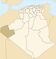
English: This map shows boundaries which are wrong or outdated. Consider using the following updated (as in 2009) map instead : File:Algeria_37_Wilaya_locator_map-2009.svg.
Français : Cette carte montre des frontières erronées ou qui ne sont plus à jour. Veuillez utiliser à la place la carte à jour (telle qu'en 2009) suivante : File:Algeria_37_Wilaya_locator_map-2009.svg.
|

|
| DescriptionDZ-37.svg |
فارسی: نقشه الجزایر که در آن استان تندوف پررنگتر شده است.
日本語: ティンドゥフ県の位置.
Norsk bokmål: Provinsen Tindoufs beliggenhet i Algerie.
Svenska: Tindoufs provins i Algeriet.
Kiswahili: Ramani ya Tindouf.
Winaray : Mapa han Alherya nga nakalutaw an lalawigan han Tindouf. |
||
| Date | |||
| Source | Image:Algeria Wilayas-blank.svg by Sémhur | ||
| Author | Escondites | ||
| Permission (Reusing this file) |
I, the copyright holder of this work, hereby publish it under the following licenses:
This file is licensed under the Creative Commons Attribution-Share Alike 3.0 Unported, 2.5 Generic, 2.0 Generic and 1.0 Generic license.
You may select the license of your choice. |
File history
Click on a date/time to view the file as it appeared at that time.
| Date/Time | Thumbnail | Dimensions | User | Comment | |
|---|---|---|---|---|---|
| current | 00:42, 14 June 2013 |  | 478 × 500 (68 KB) | Mouh2jijel (talk | contribs) | Reverted to version as of 12:07, 26 November 2007 |
| 17:56, 19 November 2009 |  | 478 × 500 (68 KB) | Sting (talk | contribs) | Reverted to version as of 12:07, 26 November 2007 | |
| 15:00, 18 November 2009 |  | 508 × 500 (70 KB) | Sting (talk | contribs) | Updated Wilayas boundaries | |
| 12:07, 26 November 2007 |  | 478 × 500 (68 KB) | Escondites (talk | contribs) | {{Information |Description= |Source=Image:Algeria Wilayas-blank.svg by {{u|Sémhur}} |Date=26 Nov 2007 |Author= Escondites |Permission={{self|GFDL|cc-by-sa-3.0,2.5,2.0,1.0}} |other_versions= }} Category:Provinces of Algeria |
You cannot overwrite this file.
File usage on Commons
There are no pages that use this file.
Metadata
This file contains additional information such as Exif metadata which may have been added by the digital camera, scanner, or software program used to create or digitize it. If the file has been modified from its original state, some details such as the timestamp may not fully reflect those of the original file. The timestamp is only as accurate as the clock in the camera, and it may be completely wrong.
| Image title | world98 |
|---|---|
| Width | 478 |
| Height | 500 |
