File:De facto cantons of Rojava.png
Jump to navigation
Jump to search
Size of this preview: 725 × 599 pixels. Other resolutions: 290 × 240 pixels | 581 × 480 pixels | 929 × 768 pixels | 1,239 × 1,024 pixels | 2,000 × 1,653 pixels.
Original file (2,000 × 1,653 pixels, file size: 268 KB, MIME type: image/png)
Captions
Captions
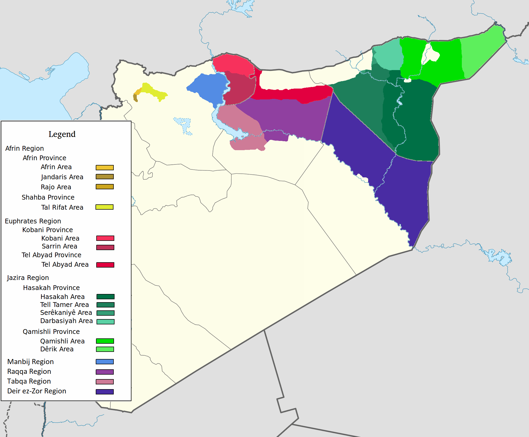
Map of de facto regions of the Autonomous Administration of North and East Syria

|
This map image could be re-created using vector graphics as an SVG file. This has several advantages; see Commons:Media for cleanup for more information. If an SVG form of this image is available, please upload it and afterwards replace this template with
{{vector version available|new image name}}.
It is recommended to name the SVG file “De facto cantons of Rojava.svg”—then the template Vector version available (or Vva) does not need the new image name parameter. |
Summary
[edit]
| Description |
العربية: اقليم عفرين اقليم الفرات اقليم الجزيرة English: Afrin Region Euphrates Region Jazeera Region No region 한국어: 아프린 주 유프라테스 주 자제라 주 없음 |
| Date | |
| Source | Own work |
| Author | Editor abcdef |
| Other versions |
This image includes elements that have been taken or adapted from this file:  |
Licensing
[edit]
I, the copyright holder of this work, hereby publish it under the following license:
This file is licensed under the Creative Commons Attribution-Share Alike 3.0 Unported license.
- You are free:
- to share – to copy, distribute and transmit the work
- to remix – to adapt the work
- Under the following conditions:
- attribution – You must give appropriate credit, provide a link to the license, and indicate if changes were made. You may do so in any reasonable manner, but not in any way that suggests the licensor endorses you or your use.
- share alike – If you remix, transform, or build upon the material, you must distribute your contributions under the same or compatible license as the original.
File history
Click on a date/time to view the file as it appeared at that time.
| Date/Time | Thumbnail | Dimensions | User | Comment | |
|---|---|---|---|---|---|
| current | 08:29, 27 May 2020 | | 2,000 × 1,653 (268 KB) | AntonSamuel (talk | contribs) | Reverted to version as of 09:02, 8 April 2020 (UTC) Restoring original map without stripes per COM:OW and discussion on the Rojava talk page on Wikipedia |
| 09:05, 8 April 2020 |  | 2,000 × 1,653 (224 KB) | Bill497 (talk | contribs) | Reverted to version as of 08:59, 8 April 2020 (UTC) Revert vandalism. | |
| 09:02, 8 April 2020 |  | 2,000 × 1,653 (268 KB) | AntonSamuel (talk | contribs) | Reverted to version as of 08:51, 8 April 2020 (UTC) Third, and last warning given on user talk page. | |
| 08:59, 8 April 2020 |  | 2,000 × 1,653 (224 KB) | Bill497 (talk | contribs) | Reverted to version as of 08:11, 8 April 2020 (UTC) Revert vandalism for a 3rd time. User is reverting a referenced map to an unreferenced version. | |
| 08:51, 8 April 2020 |  | 2,000 × 1,653 (268 KB) | AntonSamuel (talk | contribs) | Reverted to version as of 17:57, 7 April 2020 (UTC) Once again, use the Rojava talk page to discuss before making reverts and don't throw around unfounded vandalism claims. Second warning on talk page given. | |
| 08:11, 8 April 2020 |  | 2,000 × 1,653 (224 KB) | Bill497 (talk | contribs) | Reverted to version as of 11:10, 7 April 2020 (UTC) Revert vandalism. | |
| 17:57, 7 April 2020 |  | 2,000 × 1,653 (268 KB) | AntonSamuel (talk | contribs) | Reverted to version as of 00:50, 7 April 2020 (UTC) Restoring viewable version - Use Rojava talk page, warning left on user talk page | |
| 11:10, 7 April 2020 |  | 2,000 × 1,653 (224 KB) | Bill497 (talk | contribs) | Reverted to version as of 12:33, 2 April 2020 (UTC) Revert attempted vandalism into a factually incorrect version of the map. SDF has entirely no presence in some of the dashed zones. Due to fog of war these areas are all displaced as mixed with government control. Russia is the only reliable source displaying where the government is present. | |
| 00:50, 7 April 2020 |  | 2,000 × 1,653 (268 KB) | AntonSamuel (talk | contribs) | Continuation from below: ...manner. Further sources are needed apart from the Russian military maps - they cannot be considered to be neutral or factually accurate without additional verification. | |
| 00:46, 7 April 2020 |  | 2,000 × 1,653 (218 KB) | AntonSamuel (talk | contribs) | Clearing the 50/50 paint because of the visual difficulty and for deviation from the main purpose of this map - which is to display the various subregions of the civilian administration of the de facto autonomous region, not military control agreements such as SDF-SAA/Russia and SDF-US/US-led coalition which have no known civilian aspect as of date. Please discuss the issue first and foremost on the Rojava talk page if areas with an SAA/Russian or a US presence need to be highlighted in some... |
You cannot overwrite this file.
File usage on Commons
The following 4 pages use this file:
File usage on other wikis
The following other wikis use this file:
- Usage on ar.wikipedia.org
- Usage on arz.wikipedia.org
- Usage on azb.wikipedia.org
- Usage on ca.wikipedia.org
- Usage on diq.wikipedia.org
- Usage on fa.wikipedia.org
- Usage on glk.wikipedia.org
- Usage on id.wikipedia.org
- Usage on ku.wikipedia.org
- Usage on nl.wikipedia.org
- Usage on ru.wikipedia.org
- Usage on tr.wikipedia.org
- Usage on vi.wikipedia.org
- Usage on www.wikidata.org
- Usage on zh.wikipedia.org