File:Denver Public Library 1.jpg
Jump to navigation
Jump to search

Size of this preview: 800 × 516 pixels. Other resolutions: 320 × 206 pixels | 640 × 413 pixels | 1,024 × 660 pixels | 1,452 × 936 pixels.
Original file (1,452 × 936 pixels, file size: 1.25 MB, MIME type: image/jpeg)
Captions
Captions
Add a one-line explanation of what this file represents
|
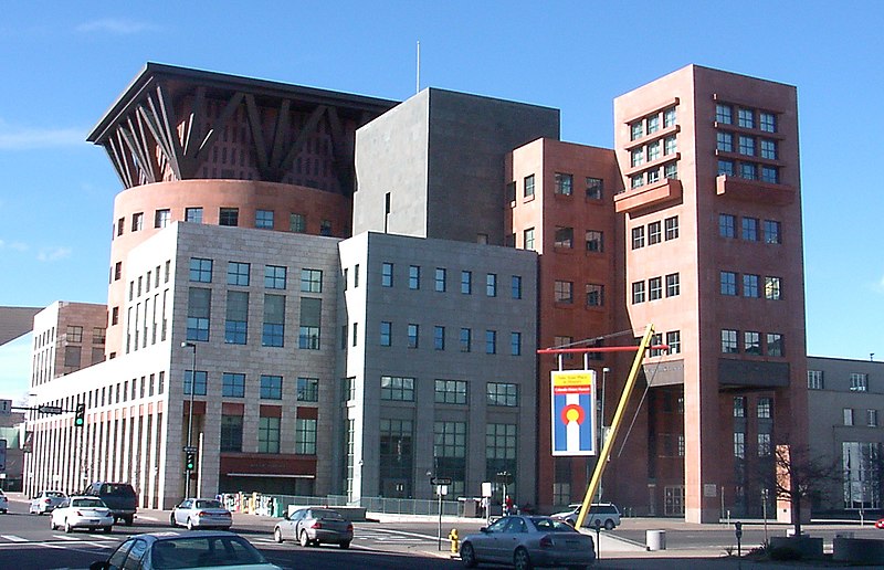
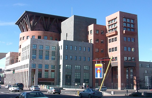
This is an image of a place or building that is listed on the National Register of Historic Places in the United States of America. Its reference number is 90001345. |
Summary
[edit]
| Description |
English: Central Library, Denver Public Library
Español: Biblioteca Central, Biblioteca Pública de Denver |
| Date | |
| Source | Own work |
| Author | KM Newnham |
| Object location | | View this and other nearby images on: OpenStreetMap |
|---|
Licensing
[edit]
This file is licensed under the Creative Commons Attribution-Share Alike 2.5 Generic license.
- You are free:
- to share – to copy, distribute and transmit the work
- to remix – to adapt the work
- Under the following conditions:
- attribution – You must give appropriate credit, provide a link to the license, and indicate if changes were made. You may do so in any reasonable manner, but not in any way that suggests the licensor endorses you or your use.
- share alike – If you remix, transform, or build upon the material, you must distribute your contributions under the same or compatible license as the original.
File history
Click on a date/time to view the file as it appeared at that time.
| Date/Time | Thumbnail | Dimensions | User | Comment | |
|---|---|---|---|---|---|
| current | 21:39, 2 January 2006 | | 1,452 × 936 (1.25 MB) | Mnewnham (talk | contribs) | Category:ArchitectureCategory:Denver, Colorado {{Information |Description = Denver Public Library |Source = Own Work |Date = 01-02-2006 |Author = KM Newnham |Permission = |other_versions = <i>none</i> |}} |
You cannot overwrite this file.
File usage on Commons
More than 100 pages use this file. The following list shows the first 100 pages that use this file only. A full list is available.
- File:'Denver from the Highlands' by Paul Frenzeny and Jules Tavernier, 1874.jpg
- File:1937 official road map, North Dakota, South Dakota - DPLA - 2d275d0cd6800bf9790cd56b7d2f03ad (page 1).jpg
- File:1937 official road map, North Dakota, South Dakota - DPLA - 2d275d0cd6800bf9790cd56b7d2f03ad (page 2).jpg
- File:A leisure time map of Denver, for members of the Armed Services - DPLA - 6229e5e5ef59dd2a002e40b1e317b2fa.jpg
- File:A tornado in the Rocky Mountains - DPLA - 55d244f77efab4affaf246a09d9ca29f.jpg
- File:Baist's real estate atlas of surveys of Denver, Col. (Plate 03) - DPLA - bb9038a474183e0992dfbed4228acb7a.jpg
- File:Baist's real estate atlas of surveys of Denver, Col. (Plate 12) - DPLA - 2cf25813c60f8e2f7dbdb82d2e117cbd.jpg
- File:Baist's real estate atlas of surveys of Denver, Col. (Plate 13) - DPLA - 13aa9e6151f93ec761d8d5d29baa6284.jpg
- File:Baist's real estate atlas of surveys of Denver, Col. (Plate 22) - DPLA - 91ee7372647cbcb1db90d3e9cb1547ae.jpg
- File:Baist's real estate atlas of surveys of Denver, Col. (Plate 29) - DPLA - e676ae8aea3e4a855bce073ba419bb4e.jpg
- File:Breckenridge, Colo., county seat, Summit County - DPLA - beb1fc98bd0304ebff81233e7cddede7.jpg
- File:City of Denver - DPLA - 99350370c0276b6e7f40eee870f5a523.jpg
- File:Clason's guide map of Denver, Colorado - DPLA - 642f5a2726c5185c3f9b48f5f90cfa29.jpg
- File:Clason's guide map of Denver, Colorado - DPLA - 9e1feda48997f51549b3cf4ae2d80fc0.jpg
- File:Colorado, Denver quadrangle - DPLA - 1097c532bc3f267b62426641ea086a16.jpg
- File:Colorado Springs map - DPLA - 2a76ec160777a662cc8c3eb01752d3b9.jpg
- File:Colton's new sectional map of the state of Colorado - DPLA - 4acb82fdff9783fc1244ca577e359614.jpg
- File:Commercial map of the city of Denver - DPLA - 4fd510b27ccf93198ccf418c121668c4.jpg
- File:Denver, Colorado, 1874 - DPLA - 036fc2a301fcc8d65bc4a1b14c74f264.jpg
- File:Denver, Colorado - DPLA - 32d265dfb7e80ae1129ca8d45bdcb725.jpg
- File:Denver, Colorado - DPLA - af0960215c2f4b3f723b26ee90def205.jpg
- File:Denver, Colorado - DPLA - f3741ef4773d302b9619c43bda7aac1b.jpg
- File:Denver City Park. - DPLA - 1ddf8e8d6285e916a5fd7a22490f9852.jpg
- File:Denver public housing site study, 1949, Tract-D vicinity south of Jefferson Park, Denver, Colorado. - DPLA - 10e7a2565fb562b137c8c8d749bff1a7.jpg
- File:Denver public housing site study, 1949, Tract-D vicinity south of Jefferson Park, Denver, Colorado. - DPLA - 633edcf3777068381b5bd44c1c19aa56.jpg
- File:Description and map of Denver Tramway's new routes and Denver's one-way street program - DPLA - fa23e6cc86b1f27eb097f0cd8fb2be75 (page 1).jpg
- File:Description and map of Denver Tramway's new routes and Denver's one-way street program - DPLA - fa23e6cc86b1f27eb097f0cd8fb2be75 (page 2).jpg
- File:Diagram of the Situation at the Battle of Wounded Knee at the time the Indians opened fire - DPLA - 43f9752f56c04c0480b9a09c22e5e6a0.jpg
- File:Distribution and concentration of persons with Spanish surnames - Denver metropolitan study area, 1960 - DPLA - 9106f49f27d9bbb13edfcb7ff234ad03.jpg
- File:District and precinct boundaries of the city and county of Denver, Colorado - as established by resolution of the election commission of the city and county of Denver, Colorado, pas - DPLA - 71d89d3f2d444144c28236df248858bc.jpg
- File:District and precinct boundaries of the city and county of Denver - as established by resolution of the Election Commission of the city and county of Denver, passed Sept 11,1937 - DPLA - 9caea4d1846ac2a3238319914886e6c5.jpg
- File:District and precinct boundaries of the city and county of Denver - as established by resolution of the Election Commission of the city and county of Denver, passed Sept 26, 1941 - DPLA - f9efb92000d14206c56ff2a1e557adf8.jpg
- File:Future service areas metropolitan Denver, Boulder and Longmont - DPLA - aaedffc79f62d2e0df9c17b2dd498be0.jpg
- File:General locality map (northern Colorado) - DPLA - d7bfa2bac80a6218027abac06e4bbea2.jpg
- File:General plan for the village of Bow-Mar, Colorado - DPLA - 61eb523663d76dcd05e5ae57902e4f4f.jpg
- File:General plan for the village of Bow-Mar, Colorado - DPLA - d23bf83b3cf9e9936b48bb23abcc971b.jpg
- File:Geological sections, sheet XVIII - DPLA - b5ca4593e8131fbb6a34202e4eae9b11.jpg
- File:Guide map to the city of Denver, Colorado - DPLA - 1490955b0dd3ce67d0c14c89c527ac67.jpg
- File:Hay Field Fight - DPLA - 8f736cb6ea2dfbdba3c19f9716286bb3.jpg
- File:Mamie Eisenhower Park Development Plan Image 1 - DPLA - 96b6a2bbf3a589d10b4694961d1ee546.jpg
- File:Map of Brown, Sherman, Republican and Leavenworth Mountains Colorado - DPLA - 58d0496b441a84af38c53422fd52dc67.jpg
- File:Map of Colorado Territory, United States - DPLA - 6f1933128ed8b5cb38084a2e7ae991d7.jpg
- File:Map of Colorado Territory - DPLA - 932ef8c896be1de660571df98784ed2f.jpg
- File:Map of Denver's business center - from Union Depot to State Capitol... - DPLA - d2c8314c12726735199d930592f120ac.jpg
- File:Map of Denver, the capital of Colorado - compiled from the official records - DPLA - 3bffa4c87278a977062feb1ccee34640.jpg
- File:Map of Denver & surroundings, from Sloan's Lake and Berkerly Park in west, to Boston Heights in east. - DPLA - 7e8657db1b47f7c20a1eaf2403e6b647.jpg
- File:Map of Gilpin Co., Colo. - DPLA - 337f0de111963c22003de78799daa7a3.jpg
- File:Map of University Park Denver, Colorado - DPLA - 91c0c7cb8040612ad571f4eda7a644b7.jpg
- File:Map of northwestern Colorado - DPLA - 794486fb3a6b406d6cc9cda2ae1089a0.jpg
- File:Map of the Trenchara and Costilla Estates forming the Sangre De Christo Grant - situate in San Luis Valley, Colorado Territory - DPLA - b08256355eba9b1fee4809b7004ca274.jpg
- File:Map of the United States - DPLA - 5f03bf3bb6db46ed511f436337daebff.jpg
- File:Map of the United States and Territories together with Canada &c. - DPLA - 3794f8c299cb54eb01585176cc80b444.jpg
- File:Map of the central portion of the city of Denver - DPLA - d1e5b0b283cfcccc6e0e266134137356 (page 1).jpg
- File:Map of the central portion of the city of Denver - DPLA - d1e5b0b283cfcccc6e0e266134137356 (page 2).jpg
- File:Map of the town of Basalt - DPLA - 69be30b89d139962c104dc852f8bc878.jpg
- File:Ninth Street Historic District Planting Plan - DPLA - c7b7fa23ee278e0c353d6a781a56e2ad.jpg
- File:Official map of Denver. - DPLA - d88e666beea983130f74b6702644f280.jpg
- File:Official route map of the Denver Tramway Corp. - DPLA - c6505b825ae42e53f5aee419973bb24a.jpg
- File:Old Town Mine plat with map - DPLA - ffc206aae71ba3c96eb014283650f56d.jpg
- File:Photograph of an illustrated relief map of Colorado Springs & Cripple Creek District Railway line - DPLA - 1de20d444b96d6d697731fe8ff53b16d.jpg
- File:Plan of rustic shelter for Congress park - DPLA - 5dfd4ff15b97e534fcc9920e6f2b7850.jpg
- File:Plat of portion of Water District no. 8, in South Platte Division (no. 1), State of Colorado - DPLA - 210d89fc1421df72bb5eb11a780abacd.jpg
- File:Plate 13 of King's 1933 aerial coverage of Denver, Colorado - DPLA - a27d147c6fc034afa7cb10ebfc8dc1c7.jpg
- File:Plate 31 of King's 1933 aerial coverage of Denver, Colorado - DPLA - 167880c9dce06cf9f5974c15770753f1.jpg
- File:Plate 38 of King's 1933 aerial coverage of Denver, Colorado - DPLA - 1ac19f7057b796c865b26c9bd75c7bcb.jpg
- File:Plate 42 of King's 1933 aerial coverage of Denver, Colorado - DPLA - 1a3d78bafbef39dca37d6f72a74d6e3f.jpg
- File:Plate 43 of King's 1933 aerial coverage of Denver, Colorado - DPLA - 68967f9c9f229e78ce184bd75c3b6471.jpg
- File:Plate 49 of King's 1933 aerial coverage of Denver, Colorado - DPLA - 4c3f5ad9bfac4097b95c9f8deb8e1a21.jpg
- File:Plate 50 of King's 1933 aerial coverage of Denver, Colorado - DPLA - 05c4b5c382655810cdafd1f5128e43e3.jpg
- File:Plate 57 of King's 1933 aerial coverage of Denver, Colorado - DPLA - bfdaadb977dfc9ce9871b43bd5bb2c1a.jpg
- File:Plate 65 of King's 1933 aerial coverage of Denver, Colorado - DPLA - ccc04a627f3e73dff0b320d5d62f65c5.jpg
- File:Plate 70 of King's 1933 aerial coverage of Denver, Colorado - DPLA - 83623d78b711f920d8ec1ea198660202.jpg
- File:Plate 83 of King's 1933 aerial coverage of Denver, Colorado - DPLA - 30044d978fcb666402842aa40062c0e3.jpg
- File:Plate 89 of King's 1933 aerial coverage of Denver, Colorado - DPLA - 308fed8d9d38cab16e0a4fae3e98c2bf.jpg
- File:Population distribution - Denver metropolitan study area, 1960 - DPLA - 75a5956ae6e5fff6933eb213484b73d1.jpg
- File:Post route map of the State of Colorado - DPLA - dead92060869f2e6e65b7b43947a542b.jpg
- File:Potter Highlands, Denver, Colorado Territory - being the N.E. 1-4 Sec 29 T3S R68W. - DPLA - 2567f81de51a43045f231b7a58b01200.jpg
- File:Prather's aerial view of Denver mountain parks and Mt. Evans region - DPLA - 25dc2ea40d9e72f82b98c6afa0a73871.jpg
- File:Proposed land use - Skyline - DPLA - ee0b811bea0d67d66c0af28cda36d719.jpg
- File:Relief map of Colorado showing territory served by Public Service Company of Colorado and subsidiaries - DPLA - 0df6fbee771d46f96c57b6cb5de89280.jpg
- File:Robinson Atlas of the City of Denver (Plate 05) - DPLA - b756820abb2783b015f04fd5ddf06b38.jpg
- File:Robinson Atlas of the City of Denver (Plate 14) - DPLA - 3c103921ff453c17b045a549968899b1.jpg
- File:Robinson Atlas of the City of Denver (Plate 16) - DPLA - c418c36c09cc1184ebf49130972684b5.jpg
- File:Robinson Atlas of the City of Denver (Plate 17) - DPLA - e9c86199438cc86d1b2b2e82f59f88cb.jpg
- File:Robinson Atlas of the City of Denver (Plate 29) - DPLA - 5520c95129b67db61e6c58452bcb10b7.jpg
- File:Rollandet's map of the city of Denver, Colorado - DPLA - 0b5962f313aefa67ad7170956a39b8ba.jpg
- File:Rollandet's map of the city of Denver, pocket edition - DPLA - e656a435288f78e1fc7793161fdeae81.jpg
- File:Skyline Project area land use map - DPLA - e6d686a6f308b63078ed794c5c5ebc37.jpg
- File:Thayer's map of Denver, Colorado - DPLA - 72e68334e32d4e1fe4b8d98b5975e448.jpg
- File:The City of Denver - DPLA - 3e1ff7b751a106e963750715f46429cc.jpg
- File:The Denver & Rio Grande system - DPLA - 5d9bb8fa0e514245339053304175ba87.jpg
- File:The English Westerners' Brand Book - DPLA - 7d1a0e9bda9eeee77f25b73f7a3174c3.jpg
- File:The Leadville mining district - DPLA - 9b91a1e983d70d0c26da37439af088cc.jpg
- File:Township 3 south, range 69 west - DPLA - 534805ae7336435e7d489f5b991d7764.jpg
- File:Villa Park Map - DPLA - 649bc9aa2905dd36fa5e0401f4902479.jpg
- File:Willits farm map - DPLA - 901fb1578eecf96488f7ae17f68efd5e (page 1).jpg
- File:Willits farm map - DPLA - 901fb1578eecf96488f7ae17f68efd5e (page 2).jpg
- File:Willits farm map - DPLA - 901fb1578eecf96488f7ae17f68efd5e (page 3).jpg
- File:Willits farm map - DPLA - 901fb1578eecf96488f7ae17f68efd5e (page 4).jpg
- File:Willits farm map - DPLA - 901fb1578eecf96488f7ae17f68efd5e (page 5).jpg
.jpg)
.jpg)
_-_DPLA_-_bb9038a474183e0992dfbed4228acb7a.jpg)
_-_DPLA_-_2cf25813c60f8e2f7dbdb82d2e117cbd.jpg)
_-_DPLA_-_13aa9e6151f93ec761d8d5d29baa6284.jpg)
_-_DPLA_-_91ee7372647cbcb1db90d3e9cb1547ae.jpg)
_-_DPLA_-_e676ae8aea3e4a855bce073ba419bb4e.jpg)
.jpg)
.jpg)
_-_DPLA_-_d7bfa2bac80a6218027abac06e4bbea2.jpg)
.jpg)
.jpg)
,_State_of_Colorado_-_DPLA_-_210d89fc1421df72bb5eb11a780abacd.jpg)
_-_DPLA_-_b756820abb2783b015f04fd5ddf06b38.jpg)
_-_DPLA_-_3c103921ff453c17b045a549968899b1.jpg)
_-_DPLA_-_c418c36c09cc1184ebf49130972684b5.jpg)
_-_DPLA_-_e9c86199438cc86d1b2b2e82f59f88cb.jpg)
_-_DPLA_-_5520c95129b67db61e6c58452bcb10b7.jpg)
.jpg)
.jpg)
.jpg)
.jpg)
.jpg)
View more links to this file.
File usage on other wikis
The following other wikis use this file:
- Usage on br.wikipedia.org
- Usage on bs.wikipedia.org
- Usage on ca.wikipedia.org
- Usage on de.wikivoyage.org
- Usage on en.wikipedia.org
- Usage on es.wikipedia.org
- Usage on fa.wikipedia.org
- Usage on fr.wikipedia.org
- Usage on he.wikipedia.org
- Usage on mk.wikipedia.org
- Usage on nn.wikipedia.org
- Usage on pt.wikipedia.org
- Usage on sv.wikipedia.org
- Usage on th.wikipedia.org
- Usage on uk.wikipedia.org
- Usage on www.wikidata.org