File:Deutscher Orden 1260.png
Jump to navigation
Jump to search
Size of this preview: 690 × 600 pixels. Other resolutions: 276 × 240 pixels | 552 × 480 pixels | 884 × 768 pixels | 1,200 × 1,043 pixels.
Original file (1,200 × 1,043 pixels, file size: 857 KB, MIME type: image/png)
Captions
Captions
Add a one-line explanation of what this file represents
Summary
[edit]| Description |
[]
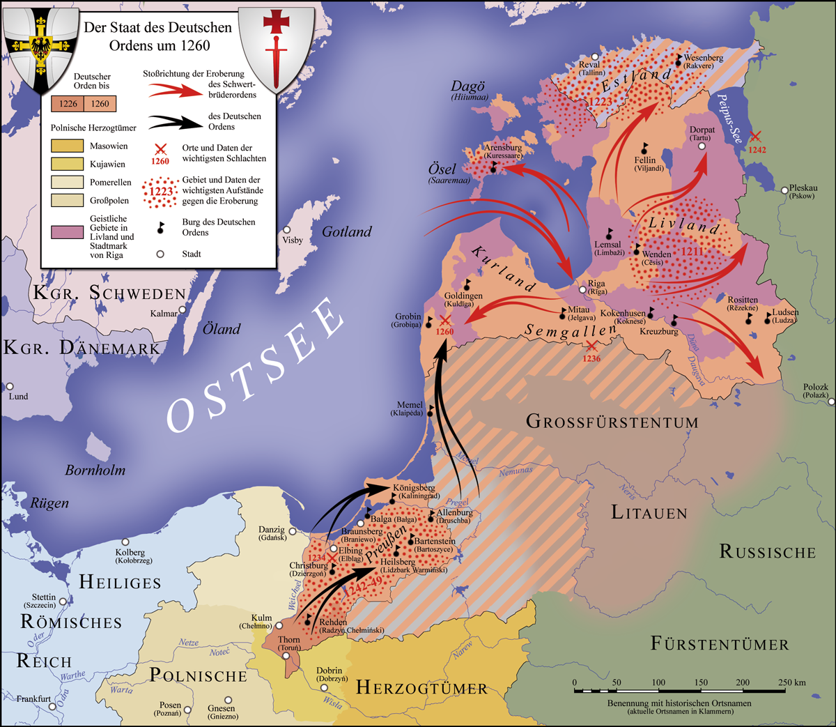
Deutsch: Der Staat des Deutschen Ordens, 1260 English: Map of the monastic state of the Teutonic Knights, 1260 Español: Mapa del Estado monástico de los Caballeros Teutónicos, 1260 Italiano: Mappa dello stato monastico dei Cavalieri Teutonici, 1260 Português: Mapa do estado eclesiástico dos Cavaleiros Teutónicos, 1260 |
||
| Date | |||
| Source |
|
||
| Author | S. Bollmann | ||
| Other versions |
Derivative works of this file: Carte croisades baltes.png []
|


Licensing
[edit]
I, the copyright holder of this work, hereby publish it under the following licenses:

|
Permission is granted to copy, distribute and/or modify this document under the terms of the GNU Free Documentation License, Version 1.2 or any later version published by the Free Software Foundation; with no Invariant Sections, no Front-Cover Texts, and no Back-Cover Texts. A copy of the license is included in the section entitled GNU Free Documentation License. |
This file is licensed under the Creative Commons Attribution-Share Alike 3.0 Unported, 2.5 Generic, 2.0 Generic and 1.0 Generic license.
- You are free:
- to share – to copy, distribute and transmit the work
- to remix – to adapt the work
- Under the following conditions:
- attribution – You must give appropriate credit, provide a link to the license, and indicate if changes were made. You may do so in any reasonable manner, but not in any way that suggests the licensor endorses you or your use.
- share alike – If you remix, transform, or build upon the material, you must distribute your contributions under the same or compatible license as the original.
You may select the license of your choice.

|
This map has been made or improved in the German Kartenwerkstatt (Map Lab). You can propose maps to improve as well.
|
File history
Click on a date/time to view the file as it appeared at that time.
| Date/Time | Thumbnail | Dimensions | User | Comment | |
|---|---|---|---|---|---|
| current | 18:19, 2 July 2017 | | 1,200 × 1,043 (857 KB) | S. Bollmann (talk | contribs) | Reverted to version as of 12:49, 9 January 2010 (UTC) the new version is - to say it careful - not really an improvement, sorry |
| 23:33, 5 November 2016 |  | 1,200 × 1,043 (436 KB) | Ulamm (talk | contribs) | recoloured in order to give a better illustration of antagonisms and alliances, see User talk:S. Bollmann | |
| 12:49, 9 January 2010 |  | 1,200 × 1,043 (857 KB) | S. Bollmann (talk | contribs) | Namenskorrektur | |
| 21:57, 18 January 2009 |  | 1,200 × 1,043 (845 KB) | S. Bollmann (talk | contribs) | {{Information |Description= |Source= |Date= |Author= |Permission= |other_versions= }} | |
| 18:39, 16 January 2009 |  | 1,200 × 1,043 (844 KB) | S. Bollmann (talk | contribs) | {{Information |Description= |Source= |Date= |Author= |Permission= |other_versions= }} | |
| 00:24, 13 January 2009 |  | 1,200 × 1,043 (779 KB) | S. Bollmann (talk | contribs) | {{Information |Description={{en|1=Map of the monastic state of the Teutonic Knights 1260}} {{de|1=Der Staat des Deutschen Ordens um 1260}} |Source=Eigenes Werk (own work) |Author=S. Bollmann |Date=13.01.2009 |Permission= |other_versio |
You cannot overwrite this file.
File usage on Commons
The following 19 pages use this file:
- File:Carte croisades baltes.png
- File:Deutscher Orden 1260+Farb.png
- File:Deutscher Orden 1260.png
- File:Deutscher Orden 1410+Farb.png
- File:Deutscher Orden 1410.png
- File:Deutscher Orden 1466+Farb.png
- File:Deutscher Orden 1466.png
- File:Mappa dello Stato dei Cavalieri Teutonici 1410.jpg
- File:Ordine Teutonico 1260.png
- File:Teutonic Order 1260-es.svg
- File:Teutonic Order 1260-fr.svg
- File:Teutonic Order 1260.png
- File:Teutonic Order 1410-es.svg
- File:Teutonic Order 1410-fr.svg
- File:Teutonic Order 1410.png
- File:Teutonic Order 1466-es.svg
- File:Teutonic Order 1466-fr.svg
- File:Teutonic Order 1466.png
- Template:Other versions/Teutonic Order maps
File usage on other wikis
The following other wikis use this file:
- Usage on ar.wikipedia.org
- Usage on ba.wikipedia.org
- Usage on be-tarask.wikipedia.org
- Usage on be.wikipedia.org
- Usage on bn.wikipedia.org
- Usage on da.wikipedia.org
- Usage on de.wikipedia.org
- Usage on de.wikiversity.org
- Usage on en.wikipedia.org
- Usage on et.wikipedia.org
- Usage on fi.wikipedia.org
- Usage on fr.wikipedia.org
- Usage on hi.wikipedia.org
- Usage on hu.wikipedia.org
- Usage on lt.wikibooks.org
- Usage on lv.wikipedia.org
- Zobenbrāļu ordenis
- Durbes kauja
- Livonijas krusta kari
- Hermans Balke
- Dītrihs fon Grīningens
- Anno fon Zangerhauzens
- Burhards fon Hornhūzens
- Ziemeļu krusta kari
- 1203. gada Kauja pie Visbijas
- Zviedru karagājiens uz Viruzemi (1196)
- Karagājiens uz Kursu un Klaipēdas dibināšana (1252)
- Kauja pie Klaipēdas (1256)
- Daugavas un Gaujas lejteces zemju pakļaušana (1193—1215)
- Igaunijas zemju pakļaušana (1208—1227)
- Daugavas kreisā krasta zemju pakļaušana (1207—1271)
- Lotigolas un Zemgales pakļaušana
- Prūsijas krusta kari
- Attēls:Livonijas ordeņa valsts 1237-1410.png
- Attēls:Livonijas ordeņa valsts dienvidu robežas izmaiņas pēc 1422. gada.png
- Usage on nl.wikipedia.org
- Usage on pl.wikipedia.org
- Usage on pt.wikipedia.org
View more global usage of this file.