File:Duchy of Prussia.svg
Jump to navigation
Jump to search

Size of this PNG preview of this SVG file: 610 × 588 pixels. Other resolutions: 249 × 240 pixels | 498 × 480 pixels | 797 × 768 pixels | 1,062 × 1,024 pixels | 2,125 × 2,048 pixels.
Original file (SVG file, nominally 610 × 588 pixels, file size: 55 KB)
Captions
Captions
Add a one-line explanation of what this file represents
Summary
[edit]| Description |
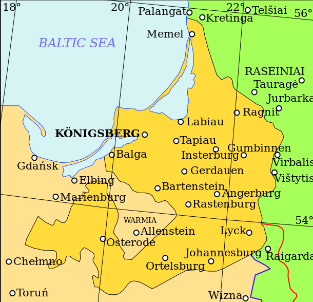
English: Map showing the Duchy of Prussia, at an indeterminable date. Place names inside the Duchy are given in German, as are Elbing and Marienburg. Other names are modern.
Territory of the Duchy of Prussia Territory of the Kingdom of Poland before the Union of Lublin Territory of the Grand Duchy of Lithuania before the Union of Lublin Polish-Lithuanian border before the Union of Lublin Polish-Lithuanian border after the Union of Lublin |
| Date | |
| Source | Own work based on: (in Lithuanian) (2001) Lietuvos istorijos atlasas, Vilnius: Vaga, pp. 16—17 |
| Author | Grandiose |
| Other versions |
|
| SVG development |

| File | Type | Details |
|---|---|---|
| File:Polish-Lithuania map (1450-1600).svg | Large SVG | Map showing conflicts and territorial changes on the Polish-Lithuanian—Russian border, 1450–1600 |
| File:Duchy of Prussia.svg | Small SVG | Map of the Duchy of Prussia |
| File:Livonian war map (1558-1560).svg | Small SVG | Map showing campaigns in Livonia, 1558–1560. |
| File:Map of Poland and Lithuania after the Union of Lublin (1569).svg | Large SVG | Map of the w:Polish-Lithuanian Commonwealth after the Union of Lublin in 1569. |
| File:Livonian war map (1570-1577).svg | Small SVG | Map showing areas of Russian and Polish-Lithuanian forces, 1570–1577. |
| File:Campaigns of Stefan Batory.svg | Small SVG | Map of the campaign of Stefan Batory in Livonia (1575–1580). |
| File:Map of Poland and Lithuania in 1600.svg | Small SVG | Map of Livonia in 1600 |
| See also: User:Halibutt/maps, by Halibutt (talk · contribs). | ||
.svg)
.svg)
.svg)
.svg)
Licensing
[edit]
I, the copyright holder of this work, hereby publish it under the following license:
This file is licensed under the Creative Commons Attribution-Share Alike 3.0 Unported license.
- You are free:
- to share – to copy, distribute and transmit the work
- to remix – to adapt the work
- Under the following conditions:
- attribution – You must give appropriate credit, provide a link to the license, and indicate if changes were made. You may do so in any reasonable manner, but not in any way that suggests the licensor endorses you or your use.
- share alike – If you remix, transform, or build upon the material, you must distribute your contributions under the same or compatible license as the original.
File history
Click on a date/time to view the file as it appeared at that time.
| Date/Time | Thumbnail | Dimensions | User | Comment | |
|---|---|---|---|---|---|
| current | 10:07, 20 April 2011 | | 610 × 588 (55 KB) | Grandiose (talk | contribs) | Correct spelling |
| 12:44, 19 April 2011 |  | 610 × 588 (54 KB) | Grandiose (talk | contribs) | Lines on longitude and latitude; other important fixes. | |
| 12:36, 19 April 2011 |  | 610 × 588 (1.1 MB) | Grandiose (talk | contribs) | Fix text locations | |
| 12:33, 19 April 2011 |  | 610 × 588 (1.1 MB) | Grandiose (talk | contribs) |
You cannot overwrite this file.
File usage on Commons
The following 2 pages use this file:
File usage on other wikis
The following other wikis use this file:
- Usage on ar.wikipedia.org
- Usage on ast.wikipedia.org
- Usage on br.wikipedia.org
- Usage on ca.wikipedia.org
- Usage on cs.wikipedia.org
- Usage on de.wikipedia.org
- Usage on el.wikipedia.org
- Usage on en.wikipedia.org
- Usage on eu.wikipedia.org
- Usage on fa.wikipedia.org
- Usage on fi.wikipedia.org
- Usage on gl.wikipedia.org
- Usage on he.wikipedia.org
- Usage on hr.wikipedia.org
- Usage on hu.wikipedia.org
- Usage on is.wikipedia.org
- Usage on it.wikipedia.org
- Usage on ja.wikipedia.org
- Usage on ko.wikipedia.org
- Usage on lt.wikipedia.org
- Usage on mk.wikipedia.org
- Usage on rue.wikipedia.org
- Usage on ru.wikipedia.org
- Usage on sc.wikipedia.org
- Usage on sh.wikipedia.org
- Usage on sv.wikipedia.org
- Usage on th.wikipedia.org
- Usage on tr.wikipedia.org
- Usage on uk.wikipedia.org
- Usage on vi.wikipedia.org
- Usage on www.wikidata.org
- Usage on zh.wikipedia.org